
Richmond, California facts for kids
Quick facts for kids
Richmond
|
|||
|---|---|---|---|
|
Aerial view of Richmond
Hotel Carquinez
Richmond Ferry Terminal
|
|||
|
|||
| Motto(s):
The City of Pride and Purpose
|
|||

Location in Contra Costa County
|
|||

Richmond, California
Location in San Francisco Bay Area

Richmond, California
Location in California

Richmond, California
Location in the United States
|
|||
| Country | United States | ||
| State | California | ||
| County | Contra Costa | ||
| Incorporated | August 3, 1905 | ||
| Named for | Richmond, Virginia, U.S. | ||
| Government | |||
| • Type | Council-Manager | ||
| • Body | City council:, Doria Robinson, Claudia Jimenez, Soheila Bana, Eduardo Martinez, Gayle McLaughlin, and Melvin Willis |
||
| Area | |||
| • City | 52.51 sq mi (136.00 km2) | ||
| • Land | 30.05 sq mi (77.84 km2) | ||
| • Water | 22.46 sq mi (58.16 km2) 42.71% | ||
| Elevation | 46 ft (14 m) | ||
| Population
(2010)
|
|||
| • City | 103,701 | ||
| • Estimate
(2019)
|
110,567 | ||
| • Rank | 2nd in Contra Costa County 54th in California |
||
| • Density | 3,678.94/sq mi (1,420.43/km2) | ||
| • Urban | 28,038 | ||
| • Metro | 4,335,391 | ||
| Time zone | UTC−8 (Pacific) | ||
| • Summer (DST) | UTC−7 (PDT) | ||
| ZIP codes |
94801, 94802, 94804, 94805, 94807, 94808, 94850
|
||
| Area code | 510, 341 | ||
| FIPS code | 06-60620 | ||
| GNIS IDs | 1659507, 2410939 | ||
.jpg)
.jpg)
.JPG)


Richmond is a city in western Contra Costa County, California, United States. It became an official city on August 3, 1905. Richmond is part of the San Francisco Bay Area's East Bay region. It shares borders with several other cities and communities.
Richmond is special because it touches both San Francisco Bay and San Pablo Bay. In 2020, its population was 116,448 people. This makes it the second-largest city named Richmond in the U.S., after Richmond, Virginia.
Contents
- Why is it Called Richmond?
- Richmond's Past: A Quick Look
- Richmond's Location and Surroundings
- Animals and Nature in Richmond
- Major Incidents in Richmond
- Who Lives in Richmond?
- Richmond's Economy
- Education in Richmond
- Fun Places and Landmarks
- Fun and Culture in Richmond
- City Events and Gatherings
- News and Media
- City Services and Transportation
- Famous People from Richmond
- Richmond's Neighborhoods
- Richmond in Books and Movies
- Sister Cities
- See also
Why is it Called Richmond?
The name "Richmond" was used long before the city was officially formed. In 1849, Edmund Randolph from Richmond, Virginia, helped survey the San Francisco Bay. He loved his hometown so much that he convinced surveyors to name "Point Richmond" and "Richmond" on their 1854 maps.
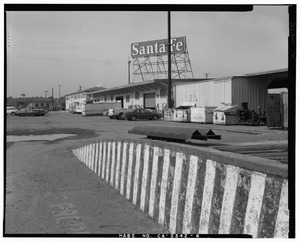
Later, the Atchison, Topeka and Santa Fe Railroad used this area as a train stop. By 1899, railroad maps showed "Point Richmond Avenue." This road later became Barrett Avenue, a main street in Richmond. The first post office opened in 1900, and the city officially became Richmond in 1905.
Richmond's Past: A Quick Look

The Ohlone people were the first to live in the Richmond area. They settled here about 5,000 years ago. They spoke the Chochenyo language and found food by hunting and gathering.
How Richmond Began
The land where Richmond now stands was once part of a large ranch called Rancho San Pablo. The Point Richmond area was first known as The Potrero. Then it was called Point Stevens on early maps of San Francisco Bay. Point Richmond used to be an island, but it was connected to the mainland by the early 1900s. This happened through industrial building and filling in land.
On July 4, 1900, the Santa Fe Railroad set up its western end at Point Richmond. Trains connected to San Francisco by ferry from Ferry Point. The Santa Fe railroad also built a big train yard nearby. They dug a tunnel through a ridge to move freight cars to a ferry landing. Two old "wigwag" railroad crossing signals still stand where the track crosses the main street in Point Richmond. These are very rare signals.
Standard Oil started its operations in 1901. This included what is now the Chevron Richmond Refinery. Chevron still runs this refinery today. There is also a pier for oil tankers in San Francisco Bay.
Early Days of the City
Richmond became an official city in 1905. Before 1919, when Prohibition started, the city had the world's largest winery. The old village of Winehaven can still be seen today. Richmond was a small town then, with some factories near the waterfront because of the railroad and oil refineries.
The Pullman Company also built a large facility in Richmond in the early 1900s. It serviced passenger trains. Pullman hired many African American men as porters. Many of them moved to the East Bay before World War II.

In 1930, the Ford Motor Company opened the Richmond Assembly Plant. This plant later moved in 1956. The old Ford plant in Richmond is now a historic site. In 2004, it was bought and turned into an events center called Ford Point Building–The Craneway.
Wartime Growth and Changes
When World War II began, four Richmond Shipyards were built. They hired thousands of workers. Many people moved to Richmond from other parts of the country for these jobs. These new workers often lived in special housing built for the war boom. Many were Black Americans from the South. Women also joined the workforce as many men went to war. Richmond's population grew from 23,000 in 1940 to about 120,000 by 1945.
A special train line, the Shipyard Railway, took workers to the shipyards. Kaiser's Richmond shipyards built 747 Victory and Liberty ships for the war. This was more than any other place in the U.S. They even built one Liberty ship in just five days! On average, a new ship was built in 30 days.
The medical system for shipyard workers became today's Kaiser Permanente HMO. The original hospital closed in 1993. It was replaced by the Richmond Medical Center hospital.
Point Richmond was the first main shopping area. But a new downtown grew in the city center along Macdonald Avenue during the war. It had big department stores like Macy's and Sears.
-
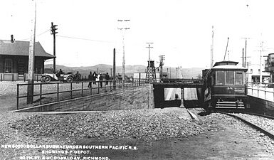
An old streetcar in downtown Richmond, 1906.
-
A large housing project built in Richmond during 1943.
-

USS General A. W. Greely, a ship built in Richmond.
-
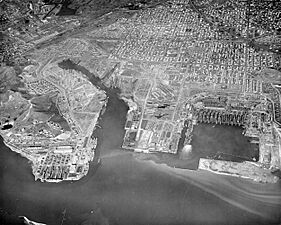
An aerial photo of Richmond Shipyards in 1944.
-
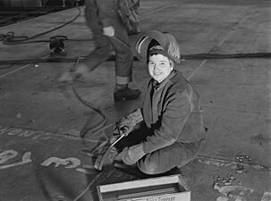
A "Wendy the Welder" helping with the war effort at Kaiser Richmond Shipyards.
-
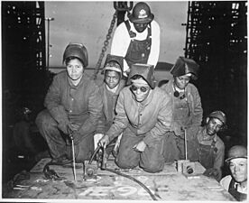
Welders at Richmond Shipyards getting ready for a test.

_at_Thule,_Greenland,_on_19_July_1951_(NH_97108).jpg)


After the War: Changes and Growth
After the war, many shipyard workers left. Richmond's population went down. By 1960, much of the temporary housing was gone. The population dropped to about 71,800.
.jpg)
In the 1970s, the Hilltop area was built in northern Richmond. This new area had the large indoor Hilltop Mall, which opened in 1976. The mall drew shoppers away from downtown. The mall, now called Hilltop Horizon, is planned to be closed and torn down. The land will be used for new homes, shops, and storage buildings.
The Richmond Parkway was built between 1990 and 1996. It connects major highways and runs along the western side of the city.
In 2006, Richmond celebrated its 100th birthday. Macdonald Avenue, the city's "Main Street," was improved with new paving and landscaping. This helped to refresh the city's old shopping area.
Richmond's Location and Surroundings
.jpg)
Richmond is located at 37°56′09″N 122°20′52″W / 37.93583°N 122.34778°W. The city covers about 52.5 square miles. About 30.1 square miles are land, and 22.4 square miles are water. Richmond has 32 miles of waterfront, more than any other city in the Bay Area. It borders San Francisco Bay and San Pablo Bay. It also includes Brooks Island and the Brother Islands. Half of Red Rock Island is also part of Richmond.
Richmond is surrounded by other cities and communities. To the south are Albany and El Cerrito. To the east are East Richmond Heights and El Sobrante. North Richmond and San Pablo are almost completely surrounded by Richmond. To the north, Richmond borders Pinole.

Richmond's Weather
Richmond has a mild Mediterranean climate all year. It's a bit warmer than San Francisco but cooler than places further inland. Average high temperatures are between 57 and 73 degrees Fahrenheit. Lows are between 43 and 56 degrees Fahrenheit. September is usually the warmest month, and January is the coldest.
The highest temperature ever recorded in Richmond was 107 degrees Fahrenheit in September 1971. The coldest was 24 degrees Fahrenheit in December 1990.
The rainy season is from late October to April. Most rain falls between November and March. January and February are the wettest months. Richmond rarely gets snow.
| Climate data for Richmond, California (1991–2020 normals, extremes 1950–present) | |||||||||||||
|---|---|---|---|---|---|---|---|---|---|---|---|---|---|
| Month | Jan | Feb | Mar | Apr | May | Jun | Jul | Aug | Sep | Oct | Nov | Dec | Year |
| Record high °F (°C) | 78 (26) |
81 (27) |
87 (31) |
94 (34) |
100 (38) |
106 (41) |
98 (37) |
103 (39) |
107 (42) |
100 (38) |
89 (32) |
76 (24) |
107 (42) |
| Mean daily maximum °F (°C) | 58.2 (14.6) |
61.3 (16.3) |
64.1 (17.8) |
67.2 (19.6) |
69.0 (20.6) |
70.1 (21.2) |
70.8 (21.6) |
72.2 (22.3) |
74.7 (23.7) |
72.8 (22.7) |
64.8 (18.2) |
58.2 (14.6) |
67.1 (19.5) |
| Daily mean °F (°C) | 51.1 (10.6) |
53.6 (12.0) |
55.8 (13.2) |
58.2 (14.6) |
60.5 (15.8) |
63.0 (17.2) |
63.0 (17.2) |
64.0 (17.8) |
65.4 (18.6) |
63.3 (17.4) |
56.7 (13.7) |
51.3 (10.7) |
58.8 (14.9) |
| Mean daily minimum °F (°C) | 44.1 (6.7) |
45.9 (7.7) |
47.4 (8.6) |
49.3 (9.6) |
52.0 (11.1) |
54.1 (12.3) |
55.2 (12.9) |
55.9 (13.3) |
56.2 (13.4) |
53.7 (12.1) |
48.7 (9.3) |
44.4 (6.9) |
50.6 (10.3) |
| Record low °F (°C) | 27 (−3) |
28 (−2) |
33 (1) |
35 (2) |
38 (3) |
43 (6) |
44 (7) |
44 (7) |
43 (6) |
41 (5) |
34 (1) |
24 (−4) |
24 (−4) |
| Average precipitation inches (mm) | 4.83 (123) |
4.76 (121) |
3.17 (81) |
1.57 (40) |
0.72 (18) |
0.27 (6.9) |
0.00 (0.00) |
0.07 (1.8) |
0.03 (0.76) |
1.42 (36) |
2.67 (68) |
4.90 (124) |
24.41 (620) |
| Average precipitation days (≥ 0.01 in) | 10.0 | 9.2 | 9.3 | 5.5 | 3.3 | 1.2 | 0.0 | 0.1 | 0.4 | 2.7 | 6.3 | 9.8 | 57.8 |
| Source: NOAA | |||||||||||||
Animals and Nature in Richmond
.jpg)
Richmond is home to many different animals. Canada geese visit during their yearly travels. Harbor seals live on Castro Rocks. You can see pigeons and gulls on sidewalks. Tadpoles and frogs live in local creeks. Field mice and lizards are also common. Herons and egrets build nests on Brooks Island. Deer, falcons, raccoons, ducks, foxes, owls, and even mountain lions live in Wildcat Canyon and Point Pinole Regional Shoreline.
You need a license to fish in city waters, but not on piers. You can catch sturgeon and bat rays. Other fish include striped bass, leopard sharks, and flounders. Richmond is one of the few places on the West Coast where you can find the rare Olympia oyster. Rainbow trout have recently returned to San Pablo and Wildcat creeks.
Red-tailed hawks fly overhead. Monarch butterflies pass through Richmond on their long trip between Mexico and Canada. Wildcat Marsh has ponds where Canada geese rest. It is also home to the endangered salt marsh harvest mouse and California clapper rail. Another endangered plant, the Santa Cruz tarweed, grows near Interstate 80. Wildcat Canyon also has falcons and vultures.

Richmond also has some environmental challenges. Because of the refineries, air quality can be low. This puts residents at higher risk for health issues from air pollution. In 2006, an environmental group sued the city for dumping raw sewage into the Bay.
In 2018, a large 60-acre solar farm opened in the city. It sits on an old landfill owned by Chevron.
Major Incidents in Richmond

Richmond is in California, a place known for earthquakes. Many buildings were damaged in the 1989 Loma Prieta earthquake. The city also has a siren system with 17 emergency warning sirens. They are tested monthly and warn of chemical releases from the Chevron Richmond Refinery.
On July 26, 1993, a chemical rail car exploded. This released poisonous gas over a 17-mile area. About 25,000 people went to the hospital.

2007 San Francisco Bay Oil Spill
Richmond's shoreline and wildlife were badly affected by the 2007 San Francisco Bay oil spill. Beaches were closed but later reopened.
2012 Chevron Refinery Fire
On August 6, 2012, a large fire started at the Chevron refinery. It sent toxic smoke into the air. Nearly 15,000 people sought medical help after the fire. Residents were told to "shelter in place" (stay indoors). The fire was put out after about four hours.
Who Lives in Richmond?
| Historical population | |||
|---|---|---|---|
| Census | Pop. | %± | |
| 1910 | 6,802 | — | |
| 1920 | 16,843 | 147.6% | |
| 1930 | 20,093 | 19.3% | |
| 1940 | 23,642 | 17.7% | |
| 1950 | 99,545 | 321.1% | |
| 1960 | 71,854 | −27.8% | |
| 1970 | 79,043 | 10.0% | |
| 1980 | 74,676 | −5.5% | |
| 1990 | 87,425 | 17.1% | |
| 2000 | 99,216 | 13.5% | |
| 2010 | 103,701 | 4.5% | |
| 2020 | 116,448 | 12.3% | |
| U.S. Decennial Census 2010 2020 |
|||
Population in 2020
In 2020, Richmond had 116,448 people. The city is very diverse.
| Race / Ethnicity (NH = Non-Hispanic) | Pop 2000 | Pop 2010 | Pop 2020 | % 2000 | % 2010 | % 2020 |
|---|---|---|---|---|---|---|
| White alone (NH) | 21,081 | 17,769 | 18,985 | 21.25% | 17.13% | 16.30% |
| Black or African American alone (NH) | 35,279 | 26,872 | 21,753 | 35.56% | 25.91% | 18.68% |
| Native American or Alaska Native alone (NH) | 351 | 250 | 266 | 0.35% | 0.24% | 0.23% |
| Asian alone (NH) | 12,077 | 13,783 | 16,460 | 12.17% | 13.29% | 14.14% |
| Pacific Islander alone (NH) | 476 | 462 | 609 | 0.48% | 0.45% | 0.52% |
| Other race alone (NH) | 400 | 585 | 1,243 | 0.40% | 0.56% | 1.07% |
| Mixed race or Multiracial (NH) | 3,233 | 3,059 | 5,220 | 3.26% | 2.95% | 4.48% |
| Hispanic or Latino (any race) | 26,319 | 40,921 | 51,912 | 26.53% | 39.46% | 44.58% |
| Total | 99,216 | 103,701 | 116,448 | 100.00% | 100.00% | 100.00% |
The median age in Richmond was 34.8 years in 2010. About 24.9% of the population was under 18.

In 2015, about 22% of Richmond's population was African-American. This was a decrease from 44% in 1990. Many people in Richmond speak a language other than English at home.
Richmond's Economy

Richmond has always been an industrial city. It once had a dynamite factory and the country's last active whaling station. It also had one of the world's largest wineries.
During World War II, Richmond grew quickly as a shipbuilding town. Today, it is a busy seaport. About 26 million tons of goods pass through Port Richmond each year. Most of these are oil and petroleum products. The oil refinery is a major part of the port.
| Largest employers in Richmond 2021 |
||
| Rank | Name | Industry |
| 1. | Chevron Corporation | Petrochemical |
| 2. | West Contra Costa Unified School District | Education |
| 3. | Kaiser Foundation Hospitals | Healthcare |
| 4. | United Parcel Service | Shipping |
| 5. | Social Security Administration | Government |
| 6. | Amazon.com services | E-Commerce |
| 7. | Permanente Medical Group | Healthcare |
| 8. | United States Postal Service (including San Francisco NDC) | Government |
| 9. | Contra Costa County | Government |
| 10. | City of Richmond | Government |
The Social Security Administration has a large office in Downtown Richmond. Kaiser Permanente's Richmond Medical Center hospital is also one of the city's biggest employers.
Shopping in Richmond

The Hilltop District has the Prologis Hilltop Center and a movie theater. The 23rd Street business district has become a mostly Latino neighborhood with many shops.
In Downtown Richmond, the Richmond Shopping Center was built to help bring life back to the city's "main street." The Macdonald 80 Shopping Center was also rebuilt in 2006.
New Developments

Starting in the late 1980s, the old Richmond Shipyard No. 2 became a new housing area called Marina Bay. Since the early 2000s, Richmond has worked to build new homes, condos, and townhomes. The city also created the Richmond Greenway, a trail and urban farming project. New homes have increased in price by 32% since 1996.
Education in Richmond

Public schools in Richmond are managed by the West Contra Costa Unified School District. There are also many private schools, mostly Catholic.
Richmond has four high schools: De Anza High School, Salesian College Preparatory, Richmond High School, and Kennedy High School. There are also charter high schools and middle schools. Richmond also has adult education schools.
Most Richmond students who go to community college attend Contra Costa College in nearby San Pablo. About 79.8% of Richmond residents over 25 have a high school diploma.
Healthy Eating in Schools
All Richmond schools have banned junk food like candy and soda. This is to help reduce childhood obesity and encourage healthier eating habits.
Fun Places and Landmarks
Richmond has many parks and historic sites. Ten sites are listed on the National Register of Historic Places.
Exploring Point Richmond

Point Richmond is a neighborhood known for its small-town feel. It has local shops and coffee places. The Masquers Playhouse offers shows all year. Hotel Mac is one of the oldest buildings, with classic early 1900s architecture. The Plunge is a public swimming pool that reopened in 2010 after repairs.
The Richmond–San Rafael Bridge stretches 5.5 miles across San Pablo Bay. It connects Richmond to Marin County. This bridge is sometimes called the "rollercoaster bridge" because of its curves.
The Richmond Chevron Refinery is north of Point Richmond. Some parts of this area are protected parks. Point Molate Beach Park is a park on the western coast. It was once a Chinese shrimp camp in the 1870s.
Discovering Brickyard Cove
The Ferry Point Tunnel is one of California's oldest tunnels, built in 1899. It connects Point Richmond to Brickyard Cove. This tunnel leads to the Golden State Railroad Museum and the USS Red Oak Victory. It also leads to beaches and parks.
The Santa Fe Railroad had ferry service to San Francisco starting in 1900. Their old station is now a museum. The Golden State Railroad Museum has many model train layouts. You can operate miniature trains and see detailed town scenes from the 1950s.
Keller Beach is one of Richmond's beaches. It's located at Miller/Knox Regional Shoreline. It's a great spot for picnics, sunbathing, and swimming. The beach offers amazing views of the Bay, bridges, and the San Francisco skyline.
Southern Waterfront and Shipyards

Further east, the USS Red Oak Victory is a restored World War II ship. It was the 558th ship built in Richmond. Liberty and Victory ships built here carried troops and supplies during the war.
The Rosie the Riveter/World War II Home Front National Historical Park is in Richmond. It honors the women who worked in factories during the 1940s. The visitor center is next to the old Ford Assembly Plant. You can take a ferry from the Richmond Ferry Terminal to San Francisco.
This area has several city parks along the waterfront. These include Lucretia Edwards Shoreline Park and Marina Bay Park. The San Francisco Bay Trail connects these parks.

Richmond Civic Center
After World War II, Richmond grew a lot. City leaders built the Richmond Civic Center between 1949 and 1957. This center has the city hall, a convention center, a library, and police headquarters.
The Richmond Public Library is in the civic center. It has over 200,000 books and many other materials.
Islands Near Richmond
East Brother Light Station is on East Brother Island. It's a special bed and breakfast that you can only reach by private boat.
The Brooks Island Regional Preserve is an island park south of the Shipyards.
Other Attractions
Richmond also has a radio-controlled model airplane airport called Breuner Airfield. It's located near Point Pinole Regional Park.
Fun and Culture in Richmond
Several regional parks are in Richmond. These include the Miller/Knox Regional Shoreline and the Point Pinole Regional Shoreline. They are connected by the San Francisco Bay Trail. Part of the old shipyard is now a marina.
The Richmond Art Center started in 1936. It's one of the oldest non-profit art centers on the West Coast. It has art shows, classes for kids and adults, and community programs.
The East Bay Center for the Performing Arts has been in Richmond since 1968. It helps young people learn about different performance traditions.
The Hyphy subculture and a type of rap music started in Richmond and nearby cities.
Religion in Richmond
Richmond has many places of worship for different religions. There are Christian churches, a large Laotian Buddhist temple, and a synagogue.
Parks and Outdoor Fun

The city has about 292.6 acres of parkland. The Rosie the Riveter World War II Home Front National Historical Park was created in 2000. It honors the women who worked during World War II. Richmond was chosen because it has many buildings from that time. The shipyards here built 747 large ships.
Wildcat Canyon Regional Park is Richmond's largest park, covering 2,428 acres. It has trails, forests, and picnic areas. You can go horseback riding or mountain biking. High school students use the park for cross-country practice.
Point Isabel Regional Shoreline is the largest off-leash dog park in the United States.
The Richmond Greenway is a project turning an old rail line into a walking, jogging, and biking trail. It will connect to other trails.
Richmond has four marinas for boats. It also has "The Richmond Plunge," a public swimming pool built in 1926.

City Events and Gatherings
Richmond has yearly Juneteenth and Cinco de Mayo celebrations. The Cinco de Mayo events on 23rd Street attract thousands of people. There are also fireworks for July 4 at Marina Bay. The city hosts an annual health and nutrition forum. Since 2010, Richmond has also celebrated the Native American Pow-Wow in Nicholl Park.
News and Media
Newspapers
Richmond has two African American weekly newspapers: the Richmond Post and Richmond Globe. RichmondConfidential.org is an online news source run by UC Berkeley. Richmond Pulse is a youth-led publication focusing on community health.
Television and Radio
KCRT-TV is a local cable TV station. It shows historical videos, city council meetings, and music videos. KKSF (AM) is a radio station that broadcasts from Point Isabel.
City Services and Transportation

The Richmond Parks & Recreation Department manages many parks. The Richmond Civic Center is being updated and renovated.

Richmond is home to the West County Detention Facility, a county jail.
RichmondWorks and Richmond Summer YouthWorks are city programs. They help reduce unemployment by finding jobs for young people.
Richmond Sanitary Service handles waste and recycling. Water comes from the East Bay Municipal Utility District (EBMUD). The city government manages sewers. Pacific Gas & Electric Company (PG&E) provides electricity and gas.
Fire Department
| Operational area | |
|---|---|
| Country | United States |
| State | California |
| City | Richmond |
| Agency overview | |
| Employees | 95+(2014) |
| Staffing | Career |
| Fire chief | Adrian Sheppard |
| EMS level | BLS |
| IAFF | 188 |
| Facilities and equipment | |
| Battalions | 1 |
| Stations | 7 |
| Engines | 7 |
| Trucks | 1 |
| Rescues | 2 |
| HAZMAT | 1 |
| Fireboats | 1 |
The Richmond Fire Department provides fire and rescue services. They also serve East Richmond Heights and North Richmond. The department has seven fire stations.

Police Department
The Richmond Police Department started in 1909. Its headquarters are at the Richmond Civic Center.
Richmond's Port
The Port of Richmond is on the city's southern coast. It handles the third-largest amount of shipping in California each year. It is the top port in the San Francisco Bay for vehicles and liquid goods. The port has 7 city-owned terminals and 11 privately owned ones. Four major rail companies serve the port.
Roads and Highways
- Interstate 80 goes through eastern Richmond. It connects to other cities like Pinole and Vallejo. It also goes through Berkeley and Oakland to San Francisco.
- Interstate 580 runs along Richmond's southern waterfront. It connects to the Richmond–San Rafael Bridge, leading to Marin County.
- The Richmond Parkway connects I-580 to I-80. It runs along the city's industrial western side.
- San Pablo Avenue (State Route 123) goes through Richmond and other cities to the north and south.
Main Streets
- Macdonald Avenue is Richmond's "Main Street." It runs east-west through downtown.
- Cutting Boulevard runs parallel to Macdonald Avenue. It's a busy route for shopping and commuting.
- 23rd Street runs north-south through the city's Latino business district.
Public Transportation
Richmond's main transportation hub is Richmond station. You can catch Bay Area Rapid Transit (BART) trains here. Amtrak trains also serve this station.

AC Transit operates 14 bus lines in Richmond. These include local routes and express buses to San Francisco. WestCAT also provides local bus service.
Train Lines for Goods
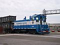
The Union Pacific Railroad (UP) has a main line through Richmond. The BNSF Railway (BNSF) has a train yard here. It's the northern end of their line that goes to Southern California. The Richmond Pacific Railroad (RPRC) is a smaller railroad that helps move goods at Richmond's wharves.
Ferry Service

The San Francisco Bay Ferry started ferry service to the San Francisco Ferry Building in January 2019. The trip takes about 35 minutes. The ferry runs from the Craneway Pavilion in Marina Bay.
Walking and Biking Paths
Richmond has built many miles of the San Francisco Bay Trail. It has more miles than any other city right now. The Richmond Greenway is a project turning an old rail line into a path for walking, jogging, and biking. There are also many trails in parks like Wildcat Canyon, Miller/Knox, and Point Pinole.
-
The Richmond–San Rafael Bridge (Interstate 580) next to Red Rock Island.
-
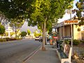
Tree-lined San Pablo Avenue with a bus stop and businesses in eastern Richmond.
-
A freight train of the Richmond Short Railroad.


Famous People from Richmond
Sports Stars
- C. J. Anderson, NFL running back.
- Ken Carter (born 1959), a high school basketball coach. The movie Coach Carter was based on his story.
- Willie McGee (born 1958), MLB player, won two batting titles.
- Percy Robert Miller (Master P), also played basketball for NBA teams.
Musicians
- Billie Joe Armstrong (born 1972), lead singer of the band Green Day.
- Peter Buck (born 1956), guitarist for the rock band R.E.M..
- Les Claypool (born 1963), bassist and singer of Primus.
- Master P (born Percy Robert Miller), a famous rapper and businessman.
- Dorothy Morrison (born 1944), lead singer for "Oh Happy Day."
Other Notable People
- Peter S. Beagle (born 1939), author of the fantasy novel The Last Unicorn.
- Carl Franklin (born 1949), director of films like Devil in a Blue Dress.
- Betty Reid Soskin (born 1921), park ranger and activist.
Richmond's Neighborhoods

Richmond has many different neighborhoods. The city can be divided into northern (Hilltop/El Sobrante), eastern (Central/East Richmond), downtown (Iron Triangle), and southern (Point Richmond/Marina Bay) areas.
Richmond in Books and Movies
Books
- In Contempt by Christopher A. Darden (Christopher Darden, a lawyer in the O.J. Simpson case, grew up in Richmond).
- The Color of Law: A Forgotten History of How Our Government Segregated America by Richard Rothstein (2017).
Movies and TV Shows
- The movie Tucker: The Man and His Dream was filmed at the old Ford Assembly Building.
- Parts of the movie Patch Adams with Robin Williams were filmed in Point Richmond.
- The basketball movie Coach Carter was based on the Richmond High School team's story.
- In the TV show The Game, the character Latasha "Tasha" Mack grew up in Richmond.
- Many scenes from the movie Forever Young with Mel Gibson were filmed in Point Richmond.
Sister Cities
Richmond, California, has three sister cities:
|
See also
 In Spanish: Richmond (California) para niños
