
Wildcat Canyon Regional Park facts for kids
Quick facts for kids Wildcat Canyon Regional Park |
|
|---|---|

Wildcat Canyon vistas 2019
|
|
| Lua error in Module:Location_map at line 420: attempt to index field 'wikibase' (a nil value). | |
| Location | Contra Costa County |
| Area | 2,429-acre (983 ha) |
| Operated by | East Bay Regional Park District |
Wildcat Canyon Regional Park is a huge park covering 2,429-acre (983 ha) in Richmond, Contra Costa County. It's part of the East Bay Regional Park District and is located in the beautiful San Francisco Bay Area of California. This park includes parts of Wildcat Canyon and San Pablo Ridge. It's also connected to Tilden Regional Park, which is another popular park nearby.
Contents
Park History: How Wildcat Canyon Park Began
The land where Wildcat Canyon Regional Park now stands was once home to Native American communities. In 1772, a group of Spanish explorers and missionaries, led by Pedro Fagas and Fray Juan Crespi, arrived while looking for new trade routes.
Later, around 1840, the Spanish began dividing the land. They used it for missions and raising cattle. This was different from how Native Americans traditionally shared and used the land. Juan Jose and Victor Castro were given rights to much of the empty land. They kept some valuable parts and gave other areas to local authorities for water use.
In 1935, the East Bay Regional Park District started buying land to create Tilden Park. They kept buying more land north of Tilden. By 1976, they had enough land to officially create Wildcat Canyon Regional Park.
Recent Park Expansion
On February 17, 2014, the East Bay Regional Park District announced exciting news! They bought 362 acres (146 ha) of new woodland. This land is on the east side of Wildcat Canyon Regional Park and has been added to the park. This expansion makes it easier for visitors from El Sobrante and Richmond to get into the park. The land was once planned for houses, but the park district was able to buy it.
Flora: Plants and Trees in the Park
Wildcat Canyon Regional Park is full of different plants and trees. You can find many types of trees here, like Coast Live Oak, California Bay Laurel, Big Leaf Maple, Madrone, alder, willow, Dogwood, and eucalyptus.
The park also has areas with thick shrubs, called chaparral. These areas include plants like coyote brush, poison oak, elderberry, snowberry, bracken fern, and blackberry bushes.
While some native grasses grow here, you'll mostly see non-native grasses like rye, barley, and oat. But don't worry, many kinds of beautiful native flowers also bloom in the park!
Fauna: Animals Living in the Park
Wildcat Canyon Regional Park is home to many different animals. You might spot coyotes, foxes, raccoons, skunks, opossums, and deer. There are also California ground squirrels, which some people mistake for gophers, along with voles.
Reptiles and Birds
If you're lucky, you might see some reptiles like gopher snakes, king snakes, western racers, garter snakes, rubber boas, and ringneck snakes.
Look up into the sky to see many birds! You can often spot red-tailed hawks, American kestrels, sharp-shinned hawks, Cooper's hawks, crows, and turkey vultures. Great horned owls and many different songbirds also live in the park.
Major Trails: Exploring Wildcat Canyon
The park has several great trails for hiking, biking, and exploring.
Wildcat Creek Trail
This trail follows Wildcat Creek. It starts at the Alvarado Park entrance in Richmond and goes into Tilden Park's Nature Area. The part of the trail within Wildcat Park is 3.5 miles long. It then continues for another 1 mile into Tilden Park. This trail is wide and mostly flat, so it's easy to walk. You can also get to the middle of this trail from Rifle Range Road in El Cerrito, California.
Nimitz Way
Nimitz Way is named after Admiral Chester W. Nimitz. It starts at Inspiration Point in Tilden Park. This trail is mostly paved and connects to Wildcat Canyon Park after 1.5 miles. The section within Wildcat Park is 2.51 miles long and connects to the San Pablo Ridge Trail. Nimitz Way is a popular and fairly easy trail. It offers amazing views of the San Francisco Bay to the west. You can also see EBMUD's San Pablo Reservoir and Briones Reservoir, plus Mount Diablo.
Belgum Trail
The Belgum Trail is named after Dr. Belgum, who used to run a health center near here. You can get to this trail from the Wildcat Creek Trail, about 0.5 miles from the Alvarado Park entrance. It climbs quickly over a short 0.85 miles to reach Wildcat Canyon's open meadows. This trail gives you excellent views of the San Francisco Bay.
San Pablo Ridge Trail
You can reach the San Pablo Ridge Trail from the Belgum Trail or the Clark-Boas Trail. The Clark-Boas Trail starts from the Clark Road park entrance in Richmond. The San Pablo Ridge Trail is 1.43 miles long and goes over three small peaks. At its southern end, it connects with Nimitz Way.
Other Interesting Park Features
Alvarado Park
Alvarado Park is the northernmost part of Wildcat Canyon. It's also a National Historic Place, meaning it's an important historical site.
Former Nike Missile Base
A 2-mile section of Wildcat Canyon Regional Park was once a Nike missile base. This was a military site that was closed down in the 1970s. Today, you'll find very few signs of the missile silos or military buildings that used to be on these hills.
Cattle Grazing Program
You might see cows grazing on the hills of Wildcat Canyon Regional Park. The East Bay Regional Park District manages a program where cattle help keep the grass short. This helps reduce fire risk and manage the plant life in the park.
Accessing the Park: How to Visit
You can enter Wildcat Canyon Regional Park from several different spots:
- The main entrance and park office are in the Alvarado Park area on Park Avenue in Richmond. You can get there from McBryde Avenue.
- The Clark Road entrance is in the northern part of the park, off of San Pablo Dam Road.
- You can also enter from Rifle Range Road in El Cerrito.
- Another entry point is Leisure Lane, which is also off of San Pablo Dam Road.
Images for kids
-
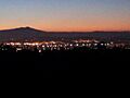
Richmond as seen from Wildcat Canyon Regional Park at dusk looking West on 14 November 2013
-
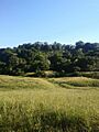
A field and woods in the park
-
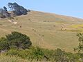
Cows and hikers on a hillside in Wildcat Canyon Regional Park


