
San Francisco Bay facts for kids
Quick facts for kids San Francisco Bay |
|
|---|---|
.jpg) |
|

San Francisco Bay
Location in California
|
|
| Coordinates | 37°40′N 122°16′W / 37.67°N 122.27°W |
| Type | Bay |
| River sources | Sacramento River San Joaquin River Petaluma River Napa River Guadalupe River |
| Ocean/sea sources | Pacific Ocean |
| Basin countries | United States |
| Max. length | 97 km (60 mi) |
| Max. width | 19 km (12 mi) |
| Surface area | 400–1,600 sq mi (1,000–4,100 km2) |
| Average depth | 12–15 ft (3.7–4.6 m) |
| Max. depth | 372 ft (113 m) |
| Settlements | San Francisco San Jose Oakland |
| Official name: San Francisco Bay/Estuary (SFBE) | |
| Designated: | February 2, 2013 |
| Reference #: | 2097 |

San Francisco Bay is a very large body of water in California, United States. It is a type of estuary, which means it's where fresh water from rivers mixes with salt water from the ocean. The bay gives its name to the San Francisco Bay Area, a region that includes big cities like San Francisco, San Jose, and Oakland.
The San Francisco Bay collects water from about 40 percent of California. Rivers like the Sacramento River and San Joaquin River, along with water from the Sierra Nevada mountains, flow into Suisun Bay. This water then travels through the Carquinez Strait to meet the Napa River at the entrance to San Pablo Bay. San Pablo Bay then connects to San Francisco Bay, which finally opens up to the Pacific Ocean through the Golden Gate strait. Even though there are several connected bays, people often call the whole system "San Francisco Bay." On February 2, 2013, the bay was named a Ramsar Wetland of International Importance, which means it's a very important wetland globally. The Port of Oakland on the bay is one of the busiest shipping ports on the west coast of the U.S.
Contents
How Big is San Francisco Bay?
The size of San Francisco Bay can be measured in different ways, but it covers between 400 and 1,600 square miles (1,000–4,000 km2). This depends on whether smaller bays, wetlands, and other areas are included. The main part of the bay is about three to twelve miles (5–19 km) wide from east to west. It stretches between 48 miles (77 km) and 60 miles (97 km) from north to south. It is the largest Pacific estuary in North and South America.
Long ago, the bay was deep enough for ships to sail as far south as San Jose. But in the 1850s, a type of mining called hydraulic mining washed a lot of dirt and rocks from rivers into the bay. This sediment settled in the shallower parts of the bay, making them less deep. Over time, people also filled in wetlands and other parts of the bay, reducing its size by about one-third since the mid-1800s. Recently, some of these wetlands have been restored, which helps the environment but also changes the bay's exact size.
For many years, the marshy wetlands around the bay were seen as empty space. So, dirt from building projects or from digging deeper channels was often dumped into these wetlands and other parts of the bay to create new land. From the mid-1800s to the late 1900s, more than a third of the bay was filled in and built upon. The soft, wet soil in these filled-in areas can act like liquid during earthquakes. This is called soil liquefaction. Much of the damage near the bay during the 1989 Loma Prieta earthquake happened to buildings on these filled-in areas.
For example, the Marina District in San Francisco, which was badly hit by the 1989 earthquake, was built on land filled in for the 1915 Panama-Pacific International Exposition.
Islands in the Bay
There are five large islands in San Francisco Bay:
- Alameda is the biggest island. It was created in 1901 when a shipping channel was dug to form the Port of Oakland. It's now a community where many people live.
- Angel Island was once called "Ellis Island West." This is because it was a main entry point for immigrants coming from East Asia. Today, it's a state park that you can visit by ferry.
- Yerba Buena Island is a hilly island with a tunnel that connects the two parts of the San Francisco–Oakland Bay Bridge.
- Next to Yerba Buena Island is Treasure Island, which is flat and man-made. It was built for the 1939 Golden Gate International Exposition. Both Yerba Buena and Treasure Island were military bases until the 1990s and are now being developed for other uses.
- Alcatraz is in the middle of the bay. It's famous for being a federal prison, but it's no longer used as one. It's now a very popular place for tourists to visit.
- Even though it's called Mare Island, it's actually a peninsula (land surrounded by water on three sides) in the northern part of the bay, not a true island.

How San Francisco Bay Was Formed
.jpg)
Scientists believe San Francisco Bay was formed by the Earth's crust bending downwards between two major fault lines: the San Andreas Fault to the west and the Hayward Fault to the east. About 560,000 years ago, a shift in the Earth's plates caused a large inland lake, Lake Corcoran, to overflow. This water carved its way through the central valley and the Carquinez Strait, creating canyons in what is now the northern part of San Francisco Bay and the Golden Gate strait.
Over thousands of years, during the Ice Ages (called the Pleistocene epoch), the area that is now San Francisco Bay was sometimes a dry river valley and sometimes filled with seawater. During the Wisconsin Glaciation, about 15,000 to 10,000 years ago, the bay basin was a river valley with small hills. The Sacramento River flowed through the Golden Gate Strait directly into the ocean.
Around 11,000 years ago, the giant ice sheets began to melt, causing the sea level to rise quickly, about one inch each year. Melting glaciers in the Sierra Nevada mountains sent huge amounts of sediment down the Sacramento and San Joaquin rivers. This sediment built up on the shores of the bay, forming large mudflats and marshes that were perfect homes for local wildlife. By 5000 BC, the sea level had risen 300 feet (90 m), filling the valley with water from the Pacific Ocean. The Farallon Islands are actually what used to be hills along the old coastline.
History of San Francisco Bay
The first people to live around San Francisco Bay were the Ohlone Native Americans.
European Discovery
The first European to likely see San Francisco Bay was N. de Morena in 1579. He was left behind by Sir Francis Drake at Drakes Bay and then walked to Mexico.
The first official European discovery of San Francisco Bay happened on November 4, 1769. Spanish explorer Gaspar de Portolá was looking for the Port of Monterey but went too far north. He reached the top of Sweeney Ridge, a 1,200-foot-high (370 m) hill, where he first saw the bay. Portolá and his group didn't realize how important their discovery was. They thought it was just a large arm of what is now called Drakes Bay. At that time, Drakes Bay was known as Bahia de San Francisco, so both bodies of water were linked to that name. Eventually, the larger, more important San Francisco Bay took the name completely.
The first European to actually sail into the bay was the Spanish explorer Juan de Ayala. He sailed through the Golden Gate on August 5, 1775, in his ship, the San Carlos. He anchored in a bay near Angel Island, which is now called Ayala Cove. Ayala explored the San Francisco Bay Area, and his mapmaker, José de Cañizares, created the first map of the area. Many place names we use today come from that first map, like Point Reyes, Angel Island, Farallon Islands, and Alcatraz Island.
American Control and Growth
The United States took control of the region from Mexico during the Mexican–American War (1846–1848). On February 2, 1848, the Mexican area of Alta California became part of the United States. A year and a half later, California asked to join the United States and became the 31st state on September 9, 1850.

In 1921, a special tablet was placed in downtown San Francisco to mark where the original shoreline of the bay was. It shows how much the land has changed over time.
The bay became a very important center for American settlement and trade in the western U.S. throughout the 1800s. During the California Gold Rush (1848–1855), San Francisco Bay suddenly became one of the world's biggest seaports. It was the main shipping hub in the American West until the late 1800s. The bay's importance grew even more when the first transcontinental railroad reached its western end in Alameda on September 6, 1869.

In 1910, the Southern Pacific railroad built the Dumbarton Rail Bridge, the first bridge to cross San Francisco Bay. The first bridge for cars, the Dumbarton Bridge, was finished in January 1927. More bridges were built later, including the famous San Francisco–Oakland Bay Bridge in 1936 and the Golden Gate Bridge in 1937.
Protecting the Bay


In the 20th century, there were plans, like the 1940s Reber Plan, to fill in parts of the bay to create more industrial areas. In 1959, a report warned that if filling continued, the bay would become as small as a shipping channel by 2020. This led to the start of the Save the Bay movement in 1960. This group worked to stop the filling of wetlands and the bay, which had already shrunk to two-thirds of its original size.
Today, San Francisco Bay is still a very busy area with many industries and cities. The San Francisco Bay Area is the second-largest urban area in the American West, with about seven million people living there.
Wildlife and Nature in San Francisco Bay


Even with all the cities and industries, San Francisco Bay and the Sacramento–San Joaquin River Delta are incredibly important natural areas in California. Many fish, like California's Dungeness crab, California halibut, and Pacific salmon, use the bay as a "nursery" where their young grow up. The remaining salt marshes are vital. They are home to many endangered species and help clean the water by filtering out pollution and dirt from rivers. San Francisco Bay is protected by the California Bays and Estuaries Policy.
The bay is a key stop along the Pacific Flyway, which is like a highway for birds. Millions of waterfowl (birds that live near water) use the shallow parts of the bay as a safe place to rest and feed each year. Two endangered bird species, the California least tern and the Ridgway's Rail, live here. The muddy areas of the bay are important feeding grounds for shorebirds.
San Francisco Bay was home to America's first wildlife refuge, Oakland's Lake Merritt, built in the 1860s. It also has America's first urban National Wildlife Refuge, the Don Edwards San Francisco Bay National Wildlife Refuge (SFBNWR), created in 1972.
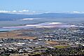
Salt Ponds
Salt is produced from San Francisco Bay in large, shallow areas called salt evaporation ponds. This salt is sent all over the Western United States for use in bakeries, canneries, and other food industries. It's also used to melt ice on winter roads, clean medical equipment, and for animal nutrition. The Leslie Salt Company was once the largest private landowner in the Bay Area because of its salt ponds.
These salt ponds create different ecosystems depending on how salty the water is. Ponds with low salt levels are like the bay itself, full of fish and birds that eat fish. Ponds with medium salt levels have lots of tiny brine shrimp, which are a rich food source for millions of shorebirds. Only special salt-loving algae can survive in the very salty ponds, and they make these ponds look deep red. The salt marsh harvest mouse, an endangered species, lives only in the wetlands of San Francisco Bay and can handle high salt levels.
Marine Mammals
For the first time in 65 years, Pacific Harbor Porpoise started returning to the bay in 2009. Scientists are studying them to see if a healthier bay is bringing them back. These porpoises usually live along the coast from California to Alaska.
Common bottlenose dolphins have also been seen more often in the bay since 2001. Evidence shows that bottlenose dolphins lived in San Francisco Bay long ago, even before recorded history.
Pollution in San Francisco Bay
Over the years, pollution has been a problem in the bay. Things like mercury from industries and mining have spread throughout the bay, affecting tiny plants (phytoplankton) and the fish that people catch.
In January 1971, two oil tankers crashed in the bay, spilling 800,000-U.S.-gallon (3,000,000-liter) of oil. This oil spill disaster helped push for more environmental protection for the bay. In November 2007, another ship hit the San Francisco–Oakland Bay Bridge and spilled over 58,000 U.S. gallons (220,000 liters) of fuel, causing a large oil spill.
The bay also has high levels of certain nutrients from treated wastewater. In other places, these nutrients can cause harmful algae blooms, but the bay has historically had fewer problems. However, in 2022, there was a very large and harmful algae bloom that caused many fish to die. This suggests that the bay's natural ways of controlling algae growth might be changing.
Chemicals called polybrominated diphenyl ether (PBDE) flame retardants, once used in furniture, were found in high levels in the bay. These have mostly been replaced, but newer flame retardants are now being found in the bay's water, mussels, and even harbor seals.

Bay Depth and Changes Over Time

The shape and depth of San Francisco Bay have changed a lot over time. Before about 1860, most of the bay's edges had large wetlands that blended into salt marshes and then muddy areas. A deep channel ran through the middle of the bay, following an old river valley that was now underwater.
In the late 1800s and early 1900s, miners dumped huge amounts of mud and gravel from hydraulic mining into the Sacramento and San Joaquin Rivers. This material flowed down the rivers and settled in the bay, especially in Suisun Bay, San Pablo Bay, and San Francisco Bay. This "slickens" (mining waste) filled in many shallow parts of the bay, making it less deep overall.

Around 1900, the U.S. Army Corps of Engineers began digging out the Sacramento and San Joaquin Rivers and the deep channels of San Francisco Bay. This process, called dredging, has continued ever since. Some of the dredged material was dumped in shallow parts of the bay, helping to create islands like Treasure Island. The dredging has kept a narrow, deep channel for ships, even though the rest of the bay has become much shallower.
Large ships need to follow these deep underwater channels, which are kept clear by frequent dredging. The average depth of the bay is only about 12 to 15 ft (4–5 m), which is about as deep as a swimming pool. Between Hayward and San Mateo to San Jose, it's even shallower, only 12 to 36 in (30–90 cm). The deepest part of the bay is under the Golden Gate Bridge, at 372 ft (113 m).
In the late 1990s, a 12-year project deepened the harbor for the Port of Oakland. This allowed larger ships to enter the bay. About six million cubic yards (160 million cubic feet; 4.6 million cubic meters) of mud from this dredging was used to create a 188-acre (0.294 sq mi; 0.76 km2) shallow-water wetland habitat for marine life. This dredging made it possible for the largest container ship to ever enter San Francisco Bay, the MSC Fabiola, to arrive.
Getting Around San Francisco Bay

| 1. | Richmond-San Rafael Bridge |
|---|---|
| 2. | Golden Gate Bridge |
| 3. | San Francisco-Oakland Bay Bridge |
| 4. | San Mateo-Hayward Bridge |
| 5. | Dumbarton Bridge |
| 6. | Carquinez Bridge |
| 7. | Benicia-Martinez Bridge |
| 8. | Antioch Bridge |
Before Europeans arrived, Native Americans used canoes to travel and fish on the bay. Later, sailing ships carried people and goods across the bay and to other parts of the world. These were slowly replaced by steam-powered boats. Many shipyards were built around the bay, especially during wartime, like the Kaiser Shipyards in Richmond during World War II.
San Francisco Bay is crossed by nine bridges, and eight of them carry cars:
- The Richmond–San Rafael Bridge connects Marin and Contra Costa counties.
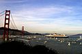
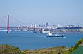
- The Golden Gate Bridge was the largest single-span suspension bridge when it was built in 1937. It crosses the Golden Gate, the strait between San Francisco and Marin County.
- The San Francisco–Oakland Bay Bridge connects Alameda and San Francisco counties.
- The San Mateo–Hayward Bridge connects Alameda and San Mateo counties.
- The Dumbarton Bridge connects Alameda and San Mateo counties.
- The Carquinez Bridge connects Contra Costa and Solano counties.
- The Benicia Bridge also connects Contra Costa and Solano counties.
- The Antioch Bridge connects Contra Costa and Sacramento counties.
- The Dumbarton Rail Bridge is an old bridge that used to carry trains but is now abandoned.
An underwater rail tunnel, the Transbay Tube, carries BART trains between Oakland and San Francisco. Before the bridges and the Transbay Tube, many ferryboats carried people across the bay. In recent years, ferries have become popular again, especially for commuters from Marin County, helping to reduce traffic on the Golden Gate Bridge.

The bay is still a major seaport. The Port of Oakland is one of the largest cargo ports in the United States. The Port of Richmond and the Port of San Francisco also handle shipping.
Fun Things to Do in San Francisco Bay
San Francisco Bay is a great place for sailing, windsurfing, and kitesurfing. The winds are usually strong and steady, and the bay is protected from big ocean waves. Yachting and boat races are popular, and many top sailors live in the San Francisco Bay Area.
There's a special path for bikes and walkers called the San Francisco Bay Trail that goes all around the edge of the bay. The San Francisco Bay Area Water Trail is also being developed. It's a growing network of places where people can launch small boats like kayaks.
Many parks and protected areas are located around the bay, including Eden Landing Ecological Reserve, Hayward Regional Shoreline, Don Edwards San Francisco Bay National Wildlife Refuge, and César Chávez Park.
The California Office of Environmental Health Hazard Assessment (OEHHA) has advice for safely eating fish caught in San Francisco Bay. This is based on levels of mercury or PCBs found in local fish.

Images for kids
-
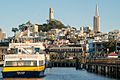
San Francisco from Forbes Island, Pier 39
-
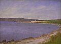
"San Francisco Bay", painting by Albert Bierstadt, 1871–73
-
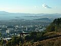
The City of Berkeley, the San Francisco Bay, and Marin County in the background as seen from the Claremont Canyon reserve
-
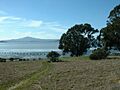
Mount Tamalpais view across San Pablo Bay at Point Pinole Regional Shoreline in Richmond
-
Looking north into San Pablo Bay at the Richmond-San Rafael Bridge, 2010
-
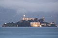
Alcatraz at dawn on San Francisco Bay
-
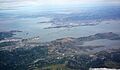
Aerial view of Golden Gate and the northern Bay, looking east from the Pacific
-
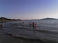
People also swim recreationally, at Kellar Beach in Richmond's Miller/Knox Regional Shoreline.
-
Oil Spill in the bay
-
RMS Queen Mary 2 in San Francisco Bay
-
Fort Baker on San Francisco Bay, just east of the Golden Gate
-
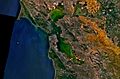
NASA satellite image, showing water flow
-
Salt ponds at the southern tip of the bay
-
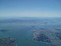
The bay seen in July 2010
-
Ships at anchor in the bay


More to Explore
 In Spanish: Bahía de San Francisco para niños
