
Guadalupe River (California) facts for kids
Quick facts for kids Guadalupe River |
|
|---|---|

Chinook salmon spawning on the Los Gatos Creek tributary of Guadalupe River by California Highway 17 in 1996
|
|

Location of the mouth of Guadalupe River in California
|
|
| Native name | Thámien Rúmmey |
| Other name(s) | Río de Nuestra Señora de Guadalupe Río de San José |
| Country | United States |
| State | California |
| Region | Santa Clara County |
| City | San Jose, California |
| Physical characteristics | |
| Main source | Lake Almaden, at confluence of Los Alamitos Creek and Guadalupe Creek San Jose, California 194 ft (59 m) 37°14′48″N 121°52′16″W / 37.24667°N 121.87111°W |
| River mouth | Alviso Slough, San Francisco Bay Alviso, San Jose, California 0 ft (0 m) 37°25′33″N 121°58′46″W / 37.42583°N 121.97944°W |
| Basin features | |
| Tributaries |
|
The Guadalupe River is a river in California. It flows north for about 14 miles (23 km). Its longer headwater creeks start in the Santa Cruz Mountains. The river begins in San Jose where Los Alamitos Creek and Guadalupe Creek meet.
It flows through San Jose and into the San Francisco Bay at the Alviso Slough. The Guadalupe River is special because it's the southernmost major U.S. river where Chinook salmon still swim to lay their eggs. Many parks are found along the river. Smaller streams from the Santa Cruz Mountains, including areas with old mercury mines, feed into the river's main branches like Los Gatos Creek and Guadalupe Creek.
Contents
History of the Guadalupe River
The Guadalupe River got its name from the Juan Bautista de Anza Expedition on March 30, 1776. They named it Río de Nuestra Señora de Guadalupe to honor the Virgin of Guadalupe. The expedition camped near the river in 1776.
In 1777, the first Mission Santa Clara and the town of San José were built near the river. Both had to be moved because of mosquitoes and winter floods. Today, Mission Santa Clara is about 2 miles (3 km) from its first spot.
Long ago, the Guadalupe River was even shorter. It started further north in a large swamp, which is now Willow Glen.
Discovery of "Lupe" the Mammoth
On July 9, 2005, the fossilized bones of a young Columbian mammoth were found in the lower Guadalupe River. A San Jose resident named Roger Castillo discovered them. Roger helped start a group to protect salmon and steelhead fish. The mammoth was nicknamed "Lupe" by local people. Lupe's fossils are now shown at the Children's Discovery Museum of San Jose.
Guadalupe River Watershed

A watershed is an area of land where all the water drains into a single river or body of water. The Guadalupe River watershed covers about 171 square miles (443 km2).
Historically, the Guadalupe River flowed into Guadalupe Slough. But in the 1870s, the river was moved to flow into Alviso Slough. This made it easier for sailboats to reach the port of Alviso. This change also disconnected some smaller streams from the river.
The Santa Clara Valley Water District (SCVWD) helps manage the river's water flow and prevent floods. There are six major reservoirs in the watershed. These include Calero Reservoir, Guadalupe Reservoir, Almaden Reservoir, Vasona Reservoir, Lexington Reservoir, and Lake Elsman.
Restoring the River Mouth

In 2009, a big project began to clear the Guadalupe River near Alviso. This area had become blocked with plants and mud. The project aims to restore 15,100 acres (61 km2) of old salt ponds back into tidal wetlands. This is part of the South Bay Salt Pond Restoration Project, which is the largest wetland restoration project on the West Coast.
River Animals and Plants


Chinook salmon have lived in the Guadalupe River watershed for a long time. Scientists found salmon DNA from the mid-1800s near Mission Santa Clara. Old records from the 1700s also mention salmon in the river. In 1904, a newspaper reported that large salmon were caught even within San Jose city limits.
Today, both steelhead trout and Chinook salmon still lay their eggs and grow in the Guadalupe River. This makes San Jose the southernmost major U.S. city with known salmon runs. Other cities with salmon include Anchorage, Seattle, Portland, and Sacramento.
Beavers in the River
California Golden beavers have returned to the Los Gatos Creek tributary. They were seen near Lake Elsman and Lexington Reservoir before 1997. In 2013, a video showed beavers in the main Guadalupe River in downtown San Jose. These are the first beavers recorded in the Santa Clara Valley since 1855.
Historically, beavers were common in the Bay Area. In 1840, John Sutter recorded that 1,500 beaver pelts were sold by Native Americans. Beaver pelts were shipped from the port of Alviso. Fur trappers hunted beavers in the area until they were almost gone.
Birds and Mercury
Caspian terns, which are large birds, come to the Bay every spring to nest. They fly all the way from Colombia. Scientists have found high levels of mercury in their eggs. The highest mercury levels were found in tern eggs near the old Cargill salt ponds at the mouth of the Guadalupe River.
A study also found that almost three-quarters of black-crowned night heron eggs in the Guadalupe watershed had too much mercury. This amount of mercury can harm bird embryos.
Flooding and Drought
The Guadalupe River sometimes floods in downtown San Jose and in Alviso. In 1995 and 1997, President Clinton declared the area a National Disaster Area due to flooding. In March 1995, a flood caused a San Jose Sharks hockey game to be canceled. This was the only time a National Hockey League game was canceled due to rain. This flood happened because the Julian Street Bridge was too small.
The river has flooded 15 times since World War II. To prevent future floods, the Santa Clara Valley Water District has started flood protection projects. A big project to control floods along the lower Guadalupe River was finished in 2008. The biggest flood on record happened in 1955, covering 8,300 acres (34 km2).
Drought Conditions
After four years of severe drought in California, the river ran dry for an 8-mile (13 km) stretch through San Jose in July 2015. This happened because there wasn't enough water stored in the upstream reservoirs to keep the river flowing until winter rains returned.
Mercury Contamination
The Guadalupe watershed was very active during the California Gold Rush. Mercury mines in Santa Clara County helped process gold. Because of this, mercury contamination is a big concern for the area. Miners used mercury to collect gold, and a lot of it was lost in the rivers and creeks.
An estimated 6,500 tons of mercury were lost between 1850 and 1920. This mercury is still found in local streams, animals, and riverbeds today. Mercury moves around during big storms. Animals at the top of the food chain, like predatory fish, birds, and mammals, are most at risk. This is because mercury builds up in their bodies through a process called biomagnification. Humans who eat contaminated fish are also at risk.
Recreation

The Guadalupe River Trail runs along 11 miles (18 km) of the river bank. It's a great place for walking, running, and biking.
Images for kids
-
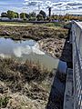
A "strainer" (a dam-like accumulation of debris) on the Guadalupe River at Alviso; such accumulations can slow the flow and contribute to upstream flooding.

See also
 In Spanish: Río Guadalupe (California) para niños
