
Los Gatos Creek (Santa Clara County) facts for kids
Quick facts for kids Los Gatos Creek |
|
|---|---|

Chinook salmon leaping passage barrier on Los Gatos Creek in December 2018
|
|

Location of the mouth of Los Gatos Creek in California
|
|
| Other name(s) | Arroyo de Los Gatos, Jones Creek |
| Country | United States |
| State | California |
| Region | Santa Clara County |
| Cities | Los Gatos, Campbell, San Jose, Holy City, Chemeketa Park |
| Physical characteristics | |
| Main source | Loma Prieta Mountain in the Santa Cruz Mountains 3,250 ft (990 m) 37°06′36″N 121°50′48″W / 37.11000°N 121.84667°W |
| River mouth | Guadalupe River San Jose, California 69 ft (21 m) 37°00′02″N 121°53′57″W / 37.00056°N 121.89917°W |
| Basin features | |
| Tributaries |
|
The Los Gatos Creek is a creek in California that flows for about 24 miles (39 km). It starts in the Santa Cruz Mountains and flows north through the Santa Clara Valley. The creek eventually meets the Guadalupe River in downtown San Jose. From there, the Guadalupe River continues into San Francisco Bay.
The creek begins in the Santa Cruz Mountains near the peak called Loma Prieta. It then flows north to Lake Elsman, which is a reservoir. After that, it passes through Holy City and Chemeketa Park. The creek then enters the Lexington Reservoir. It continues through the Los Gatos Canyon and the town of Los Gatos. It also flows into Vasona Reservoir. Finally, it goes through Campbell and San Jose before joining the Guadalupe River.
Contents
History of Los Gatos Creek
Naming the Creek
The creek was named after an old Spanish land grant called Rancho Rinconada de Los Gatos. "Los Gatos" means "The Cats" in Spanish. This name came from the cougars and bobcats that lived in the mountains nearby.
In 1839, a Spanish family was looking for a place to build a home. They heard mountain lions roaring and fighting. This sound led them to the creek, which was a good sign for water. They built their home in what is now Vasona Lake County Park.
On an 1872 map, the creek was called Arroyo de Los Gatos. Another early name was Jones Creek, given by Zachariah Jones. He founded a town called Jones Mill, which is now underwater in Lexington Reservoir.
Changes to the Creek
In 1866, a big flood caused Los Gatos Creek to change its path. It cut a new channel in the Willow Glen area of San Jose. This left behind a dry creek bed, which is now known as Dry Creek. Today, Dry Creek Road runs next to this old creek bed.
In the 1950s, State Route 17 was built. This highway project forced much of the creek in Los Gatos into a concrete channel. This was a big change to the creek's natural flow.
Also in the 1950s, the James J. Lenihan Dam was built. This dam created Lexington Reservoir. The reservoir flooded a small valley, covering the old towns of Lexington and Alma. When the water level in the reservoir is low, you can still see parts of the old highway and building foundations. Even with these changes, much of the creek still looks natural and beautiful.
Protecting Groundwater
Below Vasona Park, Los Gatos Creek helps refill underground water. This is part of a system built by the Santa Clara Valley Water District. Water from other reservoirs is also added to the creek to help recharge the groundwater.
In the 1920s, people found that the Santa Clara Valley was sinking. This was because too much groundwater was being pumped out. San Jose's elevation dropped by 13 feet between 1910 and the 1970s. The underground water table also dropped a lot. Local reservoirs like Vasona and Lexington were built to help fix this problem. They provided water for a big groundwater recharge program. By the 1980s, this program helped stop the valley from sinking further.
Wildlife and Habitat
Los Gatos Creek has always been home to many fish. In the 1880s, people reported catching 100 to 200 trout a day. Early settlers said they could even catch trout with their hands because there were so many.
Fish Species
Los Gatos Creek likely had many steelhead trout (a type of rainbow trout). These fish are known as Oncorhynchus mykiss irideus. By 1937, fewer steelhead trout were seen. This was because farm pumps lowered the water level in the creek.
However, some rainbow trout still live in parts of the creek that always have water. These are found just below and above Lexington Reservoir. The Santa Clara Valley Water District's reservoirs have helped raise the water levels again. Now, the lower part of Los Gatos Creek once again supports steelhead trout.
Chinook salmon (Oncorhynchus tshawytscha) also swim up the Guadalupe River and Los Gatos Creek from San Francisco Bay. Both Chinook salmon and steelhead trout have been seen as far up the creek as Hamilton Avenue. Scientists have studied these salmon. Some of them have unique genetic markers not found in other local salmon. This suggests they are part of a special group of California Coast Chinook salmon.
Other Animals
The part of the creek between Lake Elsman and Lexington Reservoir is very natural. It is closed to the public. Here, you can find rainbow trout, beaver, bobcats (Lynx rufus), wild boar (Sus scrofa), and puma (Puma concolor).
Beavers were brought back to the creek near Lexington Reservoir before 1992. They build dams that create pools of water. These pools are important for other animals, like birds. A beaver was even seen as a meal for a local mountain lion recently.
Historically, beavers were common here. Around 1840, Captain John Sutter wrote that 1,500 beaver pelts were sold by Native Americans to Mission San José. A beaver skull found in 1855 also proves they lived in the area.
Osprey (Pandion haliaetus), which are large fishing birds, have also returned to the area. They started nesting here again in 2004, after being absent for at least 150 years.
Los Gatos Creek Watershed
The Los Gatos Creek watershed covers about 55.1 square miles (142.7 km²). A watershed is an area of land where all the water drains into a single river or creek.
Los Gatos Creek starts on Loma Prieta Mountain in the Santa Cruz Mountains. It flows west to Williams Reservoir and then to Lake Elsman. Along the way, other smaller creeks join it. These include Austrian Gulch, Hooker Gulch Creek, Moody Gulch, and Hendrys Creek.
The creek then flows into Lexington Reservoir. Inside the reservoir, it is joined by Aldercroft Creek, Briggs Creek, Soda Springs Creek, Black Creek, Lyndon Creek, and Limekiln Creek.
Below Lexington Dam, Los Gatos Creek flows northeast. It is joined by Trout Creek. Then, it flows into Vasona Reservoir in Los Gatos. In Willow Glen, Dry Creek joins Los Gatos Creek. Finally, after crossing several roads, it joins the Guadalupe River in the Guadalupe River Park.
Recreation Along the Creek
The Los Gatos Creek Trail runs along the creek. It goes from Lexington Reservoir all the way to the Guadalupe River in downtown San Jose. This trail is very popular for hiking and bicycling.
In Los Gatos, Vasona Reservoir is located within Vasona Lake County Park. This park is one of the most popular parks in the Santa Clara County park system. The Los Gatos Creek Park is another park located in Campbell, a city that the creek flows through.
Images for kids
-
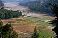
Upper Los Gatos Creek meets Lexington Reservoir
-
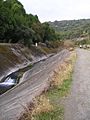
Between Lexington Reservoir and downtown Los Gatos, the creek runs next to the Los Gatos Creek Trail
-

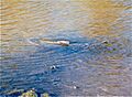
Great blue heron reflected in Los Gatos Creek
-

California golden beaver family on upper Los Gatos Creek
-
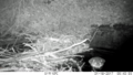
Chinook salmon spawning on Los Gatos Creek in 1996
-

Beaver dams on upper Los Gatos Creek
-
Beaver and dam on lower Los Gatos Creek


See also
 In Spanish: Arroyo Los Gatos para niños
