Los Gatos Creek Trail facts for kids
The Los Gatos Creek Trail is a super cool path for walking and biking! It's about 9.7 miles (15.6 km) long. This trail winds through Santa Clara County in California. It starts at Lexington Reservoir in Los Gatos, California and goes all the way to Meridian Avenue in San Jose, California. You'll follow the beautiful Los Gatos Creek as you explore. Lots of people love to use this trail!
Contents
Exploring the Los Gatos Creek Trail
This trail takes you on an adventure through different parts of the area. Let's explore the different sections!
From Lexington Reservoir to Los Gatos
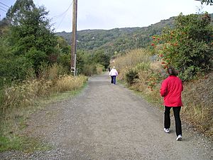
There are two paths you can take between Lexington Reservoir and downtown Los Gatos. The main Los Gatos Creek Trail is on the west side of the creek. It's a smooth, wide, unpaved path. It used to be an old railway line!
On the east side, you'll find the Jones Trail near the reservoir. This trail connects to the Flume Trail. The northern part of this trail is only for people walking. It's a bit windy and goes down close to the creek in some spots. If you're on a bike, Jones Road is a good alternative.
Both the Jones and Flume trails connect to Novitiate Park and the St. Joseph's Hill Open Space Preserve. You can find some parking at Novitiate Park and at the end of Jones Road.
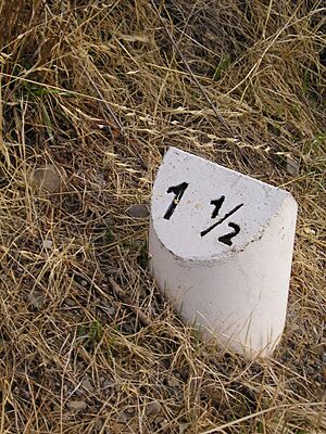
You'll see mile markers along the Los Gatos Creek Trail. Mile zero is about 100 feet (30 meters) north of the start at Alma Bridge Road. The first half-mile of the trail goes downhill quite a bit.
Downtown Los Gatos Fun
When the trail reaches downtown Los Gatos, you can get on it at the Main Street bridge. The trail then passes by the old Forbes Mill, which was built in 1854. This mill now has a history museum inside!
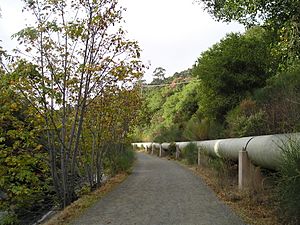
The trail then crosses Highway 17 using a special bridge just for the trail. From this point north, the trail is paved. You can get on the trail right behind the Old Town shopping area. A little further north, there's another access point and a small parking lot. This lot is next to a small park north of Old Town. You can reach it from Miles Avenue.
Vasona Lake County Park Adventure
The trail continues through Oak Meadow Park and Vasona Park. These parks have some cool attractions! You can ride the Billy Jones Wildcat Railroad. There's also a T33 airplane that kids can climb on and explore. The trail follows the east side of the lake and goes up and over the dam.
Los Gatos Creek County Park Fun
After going under Highway 85, the trail enters Los Gatos Creek County Park. In this park, you can go fishing! There's also a special casting pond for practicing your fishing skills. Plus, there's a dog park for your furry friends. A bridge for bikes and walkers crosses Highway 17 here. It connects to the trail at this spot.
Campbell Park and Downtown Campbell
The trail goes right through Campbell Park. Downtown Campbell is super close! It's just a three-block walk to the west from the trail, via Campbell Avenue. The trail is on both sides of the creek from Campbell Park south to the bridge just north of San Tomas Expressway. There's even a separate mountain bike trail east of the main trail in this area.
The Pruneyard Shopping Center
Next, the trail passes behind The Pruneyard Shopping Center in Campbell. You can get to the Pruneyard from the northwest corner of the complex. It's behind the parking garage. The Pruneyard has offices, shops, restaurants, and a movie theater.
Willow Glen Endpoint
The trail then heads through San Jose's Willow Glen neighborhood. The trail officially ends at Meridian Avenue.
Northern Trail Section to Downtown San Jose
There's a section of the trail that connects Lonus Street and Dupont Avenue. It goes under I-280. This part is important because it connects Willow Glen to Downtown San Jose. It means you don't have to cross busy streets to get between these areas. This section ends at Dupont Avenue. There are stairs right there that make it easy to get to the bridge over West San Carlos Street. This bridge crosses the creek and the Caltrain lines. It connects the trail right into central downtown San Jose.
Connecting to Other Trails
The Los Gatos Creek Trail connects to other cool trails, letting you explore even more!
Guadalupe River Trail Connection
You can reach the Guadalupe River Trail by going east on the nice bike trail on Willow Avenue. Then, turn left onto Delmas Avenue and right onto Virginia Avenue. Keep going east on West Virginia Avenue until you reach the end of the Guadalupe River Trail. It's on the north side of West Virginia Avenue, just east of the bridge over Highway 87.
Three Creeks Trail Connection
The city of San Jose has been building the Three Creeks Trail. Most of this trail is already finished. The northern end of this trail crosses Lonus Avenue. A new bridge over the creek just south of Lonus Avenue will open soon. This bridge will connect to the northern part of the Los Gatos Creek Trail. This means you won't have to travel on busy Lincoln Avenue to connect!
White Oaks Avenue Neighborhood Connection
A bridge across Highway 17 connects to the trail. This connection is at the south end of Los Gatos Creek County Park.
Los Gatos-Saratoga Road Bike Lanes Connection
You can connect to the Los Gatos-Saratoga Road bike lanes. This connection is through University Avenue and Miles Avenue. These streets are south of Los Gatos-Saratoga Road. The Town of Los Gatos is working to make this access even better.
Trail Facts: Length and Height
Here are some points along the trail and their approximate heights above sea level:
- 0.0 miles – Alma Bridge Road (660 feet)
- 1.5 miles – Main Street (400 feet)
- 2.1 miles – Miles Road
- 2.3 miles – Saratoga-Los Gatos Road (Highway 9)
- 2.9 miles – Roberts Road
- 4.3 miles – Vasona Dam (300 feet)
- 4.7 miles – Lark Avenue
- 6.3 miles – Los Gatos Creek County Park (200 feet)
- 6.5 miles – Camden Avenue / San Tomas Expressway
- 7.7 miles – Campbell Avenue (170 feet)
- 8.0 miles – Highway 17
- 8.4 miles – Hamilton Avenue
- 8.6 miles – Bascom Avenue
- 9.2 miles – Leigh Avenue
- 10.0 miles – Meridian Avenue (120 feet)
- You can find more nearby Hiking Trails in Santa Clara County on the San Jose Wiki.
 | Sharif Bey |
 | Hale Woodruff |
 | Richmond Barthé |
 | Purvis Young |


