
San Jose, California facts for kids
Quick facts for kids
San Jose
|
|||||
|---|---|---|---|---|---|
| City of San José | |||||
|
Downtown skyline
|
|||||
|
|||||
| Motto(s):
Capital of Silicon Valley
|
|||||
| Country | United States | ||||
| State | California | ||||
| County | Santa Clara | ||||
| Region | San Francisco Bay Area | ||||
| Metro | San Jose-Sunnyvale-Santa Clara | ||||
| CSA | San Jose-San Francisco-Oakland | ||||
| Pueblo founded | November 29, 1777 | ||||
| Founded as | Pueblo de San José de Guadalupe | ||||
| Incorporated | March 27, 1850 | ||||
| Named for | Saint Joseph | ||||
| Government | |||||
| • Type | Council–manager | ||||
| • Body | San Jose City Council | ||||
| Area | |||||
| • City | 181.36 sq mi (469.72 km2) | ||||
| • Land | 178.24 sq mi (461.63 km2) | ||||
| • Water | 3.12 sq mi (8.09 km2) 1.91% | ||||
| • Urban | 285.48 sq mi (739.4 km2) | ||||
| • Metro | 2,694.61 sq mi (6,979 km2) | ||||
| Elevation | 82 ft (25 m) | ||||
| Lowest elevation | 0 ft (0 m) | ||||
| Population
(2020)
|
|||||
| • City | 1,013,240 | ||||
| • Estimate
(2022)
|
971,233 | ||||
| • Rank | 32nd in North America 13th in the United States 3rd in California |
||||
| • Density | 5,684.69/sq mi (2,194.92/km2) | ||||
| • Urban | 1,837,446 (US: 28th) | ||||
| • Urban density | 6,436.4/sq mi (2,485.1/km2) | ||||
| • Metro | 2,000,468 (US: 35th) | ||||
| Demonym(s) | San Josean(s) San Joséan(s) Josefino/a(s) |
||||
| Time zone | UTC−08:00 (PST) | ||||
| • Summer (DST) | UTC−07:00 (PDT) | ||||
| ZIP Codes |
List
95002
95008 95101 95103 95106 95108–95113 95115–95141 95148 95150–95161 95164, 95170 95172 95173 95129 95190–95194 95196 |
||||
| Area code(s) | 408/669 | ||||
| FIPS code | 06-68000 | ||||
| GNIS feature IDs | 1654952, 2411790 | ||||


.jpg)
.jpg)
.jpg)
.jpg)
_(cropped).jpeg)

.svg)
San Jose, also known as the City of San José, is the largest city in Northern California. It is the most populated city in the Bay Area. San Jose is also the third-largest city in California, after Los Angeles and San Diego. In 2022, about 971,233 people lived there.
The city is located in the middle of the Santa Clara Valley, on the southern edge of San Francisco Bay. San Jose is the main city of the San Jose–Sunnyvale–Santa Clara Metropolitan Area. This area had about two million residents in 2018.
San Jose is famous for its new ideas, many different cultures, and sunny weather. It is a big part of the high tech industry, which is why it's called the "Capital of Silicon Valley". Many big tech companies like Cisco Systems, eBay, Adobe Inc., PayPal, and Zoom have their main offices here.
San Jose is one of the richest major cities in the world. It has a very expensive housing market. The city is home to many people from Vietnam and a large Hispanic community. It also has historic areas like Japantown and Little Portugal.
Before the Spanish arrived, the Tamien nation of the Ohlone people lived in the San Jose area. The city was founded on November 29, 1777. It was called Pueblo de San José de Guadalupe. This made it the first city founded in the Californias. It became part of Mexico in 1821 after Mexico won its independence from Spain.
After the Mexican–American War, the United States took control of California in 1848. When California became a state in 1850, San Jose was its first capital. After World War II, San Jose grew very quickly. It added many nearby towns and communities. The growth of high-tech and electronics companies changed the city from a farming area to a busy metropolitan center. By 1990, San Jose had more people than San Francisco. It became a global center for tech and internet companies.
Contents
What's in a Name?
San Jose is named after its original Spanish name, Pueblo de San José de Guadalupe. This means "the Town of Saint Joseph of Guadalupe". The original town was near what is now Plaza de César Chávez.
Why the Spelling Changed
In the 1800s, people often spelled the city's name "San José" with an accent mark. But in 1943, the United States Board on Geographic Names decided it should be spelled "San Jose." This was because most local people used that spelling.
Bringing Back the Accent
In the 1960s and 1970s, some people wanted to use the accent mark again. They felt it honored the city's Mexican roots. In 1969, the city's flag was designed with "SAN JOSÉ, CALIFORNIA" on it. In 1979, the city council decided to use "San José" on official city items.
Today, the city's official rules say to use the accent mark most of the time. But there are exceptions, like in website addresses or when the name is all in capital letters.
San Jose's History
![]() Spanish Empire 1777–1821
Spanish Empire 1777–1821
![]() First Mexican Empire 1821–1823
First Mexican Empire 1821–1823
![]() United Mexican States 1823–1848
United Mexican States 1823–1848
![]() California Republic 1846
California Republic 1846
![]() United States 1848–present
United States 1848–present
Early Beginnings
Before Europeans arrived, different groups of Ohlone Native Americans lived here. The first lasting European presence was started by Franciscan missionaries. They built missions starting in 1769.
On November 29, 1777, San Jose was founded by Lieutenant José Joaquín Moraga. It was named Pueblo de San José de Guadalupe. The goal was to create a farming community. This was the first non-religious settlement in Alta California.
In 1797, the town moved to its current downtown area. In 1821, San Jose became part of Mexico. Then, in 1846, it became part of the United States.
Modern Times


On March 27, 1850, San Jose became the second official city in California. Josiah Belden was its first mayor. San Jose was also California's first state capital. The Circle of Palms Plaza downtown marks this historic spot.
In the early 1900s, San Jose became a center for new inventions. People like John Joseph Montgomery worked on flying machines. The city also became known for making farm equipment.
The 1906 San Francisco earthquake caused damage in San Jose too. Over 100 people died at the Agnews Asylum. After World War II, the city's economy changed. It moved from farming to making industrial goods. Companies like Food Machinery Corporation (FMC) built military vehicles.
IBM opened a research center in San Jose in 1952. Here, the hard disk drive was invented. This helped San Jose's economy grow in technology.
During the 1950s and 1960s, City Manager A. P. "Dutch" Hamann helped the city grow a lot. San Jose added many nearby areas, like Alviso. This created large suburban areas.
Later, people worried about too much growth. Mayors Norman Mineta and Janet Gray Hayes tried to slow it down. But development continued, especially in already built-up areas.
San Jose's location in Silicon Valley led to more growth. By 1990, San Jose had more people than San Francisco. This growth also made housing very expensive. The city has focused on building more apartments and townhouses.
San Jose's Geography
San Jose is located at 37°20′07″N 121°53′31″W / 37.335278°N 121.891944°W. The city covers about 180 square miles (466 square kilometers). About 1.91% of this area is water.
San Jose is between two major fault lines, the San Andreas Fault and the Calaveras Fault. This means the city experiences small earthquakes often. The 1906 San Francisco earthquake caused a lot of damage here. The 1989 Loma Prieta Earthquake also affected parts of the city.
City Areas

The city is split into different areas. These include Downtown San Jose, Central, West San Jose, North San Jose, East San Jose, and South San Jose. Many of these areas used to be separate towns.

Other well-known communities in San Jose are Japantown, Rose Garden, Willow Glen, and Almaden Valley.
How San Jose Grew
San Jose's large size is partly due to City Manager "Dutch" Hamann. From 1950 to 1969, he led the city to annex (add) land 1,389 times. The city grew from 17 to 149 square miles (44 to 386 square kilometers). This turned many smaller communities into San Jose neighborhoods.
Hamann's plan was to bring in more sales tax money. He would identify areas for big shopping centers. Then, he would annex narrow strips of land leading to them. This created "tentacles" of the city across the valley.
Eventually, people pushed back against this fast growth. New leaders were elected, and Hamann resigned. Even though his plan wasn't fully finished, it shaped San Jose's huge size.
Famous Places in San Jose
San Jose has many interesting landmarks. These include the Children's Discovery Museum of San Jose, History Park at Kelley Park, and the Cathedral Basilica of St. Joseph.
Other popular spots are the Rosicrucian Egyptian Museum, Lick Observatory, and the Winchester Mystery House. The SAP Center at San Jose hosts many events. The San Jose City Hall is also a notable building.
-
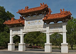
The Chinese Cultural Garden
-
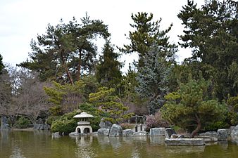
Japanese Friendship Garden

.jpg)


.JPG)


Land Features

The Guadalupe River flows through San Jose. It starts in the Santa Cruz Mountains and ends in the San Francisco Bay. The Almaden Valley area was once known for mercury mines.
The lowest point in San Jose is 13 feet (4 meters) below sea level. The highest point is 2,125 feet (648 meters). San Jose tries to reduce light pollution because of the nearby Lick Observatory. All streetlights use special lamps to help astronomers. An asteroid was even named 6216 San Jose to honor these efforts.
San Jose is near the Pacific Ocean and San Francisco Bay. The Santa Clara Valley is a major population center. This has led to a lot of suburban growth around the valley.
The city has four main valleys:
- Almaden Valley (southwest)
- Evergreen Valley (southeast, hilly)
- Santa Clara Valley (flat, main urban area)
- Coyote Valley (rural, far south)
San Jose's Climate
San Jose has a Mediterranean climate. This means it has warm, dry summers and mild, wet winters. The city gets about 301 sunny days a year. The average temperature is around 60.5°F (15.8°C).
San Jose is inland and surrounded by mountains. This protects it from some rain. It gets about 15.82 inches (40.2 cm) of rain each year. Other parts of the Bay Area can get much more.
The temperature usually ranges from around 50°F (10°C) in winter to 70°F (21°C) in summer. The highest temperature ever recorded was 114°F (46°C) in 1961. The lowest was 19°F (-7°C) in 1990.
| Climate data for San Jose, California (1981–2010 normals, extremes 1893–present) | |||||||||||||
|---|---|---|---|---|---|---|---|---|---|---|---|---|---|
| Month | Jan | Feb | Mar | Apr | May | Jun | Jul | Aug | Sep | Oct | Nov | Dec | Year |
| Record high °F (°C) | 79 (26) |
81 (27) |
89 (32) |
95 (35) |
102 (39) |
109 (43) |
108 (42) |
105 (41) |
106 (41) |
101 (38) |
85 (29) |
79 (26) |
109 (43) |
| Mean daily maximum °F (°C) | 58.1 (14.5) |
61.9 (16.6) |
65.7 (18.7) |
69.3 (20.7) |
74.3 (23.5) |
79.1 (26.2) |
81.9 (27.7) |
81.9 (27.7) |
80.1 (26.7) |
74.0 (23.3) |
64.3 (17.9) |
58.0 (14.4) |
70.7 (21.5) |
| Daily mean °F (°C) | 50.1 (10.1) |
53.3 (11.8) |
56.2 (13.4) |
58.9 (14.9) |
63.4 (17.4) |
67.5 (19.7) |
70.0 (21.1) |
70.1 (21.2) |
68.5 (20.3) |
63.2 (17.3) |
55.1 (12.8) |
50.0 (10.0) |
60.5 (15.8) |
| Mean daily minimum °F (°C) | 42.0 (5.6) |
44.7 (7.1) |
46.6 (8.1) |
48.6 (9.2) |
52.4 (11.3) |
56.0 (13.3) |
58.1 (14.5) |
58.3 (14.6) |
56.8 (13.8) |
52.5 (11.4) |
46.0 (7.8) |
41.9 (5.5) |
50.3 (10.2) |
| Record low °F (°C) | 18 (−8) |
24 (−4) |
25 (−4) |
26 (−3) |
32 (0) |
33 (1) |
40 (4) |
39 (4) |
35 (2) |
30 (−1) |
21 (−6) |
19 (−7) |
18 (−8) |
| Average rainfall inches (mm) | 3.07 (78) |
3.11 (79) |
2.54 (65) |
1.18 (30) |
0.51 (13) |
0.10 (2.5) |
0.02 (0.51) |
0.02 (0.51) |
0.18 (4.6) |
0.80 (20) |
1.68 (43) |
2.61 (66) |
15.82 (402.12) |
| Average rainy days (≥ 0.01 in) | 10.2 | 10.3 | 9.4 | 5.6 | 3.2 | 0.8 | 0.2 | 0.3 | 1.3 | 3.2 | 7.2 | 10.2 | 61.9 |
| Source: NOAA | |||||||||||||
Rain mainly falls from November to May. During winter and spring, the hills turn green. In summer, the plants dry out, which can lead to grass fires. Snow rarely falls in San Jose. The last time snow stayed on the ground was in 1976.
San Jose's People
| Historical population | |||
|---|---|---|---|
| Census | Pop. | %± | |
| 1870 | 9,089 | — | |
| 1880 | 12,567 | 38.3% | |
| 1890 | 18,060 | 43.7% | |
| 1900 | 21,500 | 19.0% | |
| 1910 | 28,946 | 34.6% | |
| 1920 | 39,642 | 37.0% | |
| 1930 | 57,651 | 45.4% | |
| 1940 | 68,457 | 18.7% | |
| 1950 | 95,280 | 39.2% | |
| 1960 | 204,196 | 114.3% | |
| 1970 | 459,913 | 125.2% | |
| 1980 | 629,400 | 36.9% | |
| 1990 | 782,248 | 24.3% | |
| 2000 | 894,943 | 14.4% | |
| 2010 | 945,942 | 5.7% | |
| 2020 | 1,013,240 | 7.1% | |
| 2023 (est.) | 969,655 | 2.5% | |
| U.S. Decennial Census 2010–2020 |
|||
In 2022, San Jose's population was 971,233. This was a small decrease since 2020. Some people are moving to more affordable cities. More people are also working from home.
| Historical racial composition | 2020 | 2010 | 1990 | 1970 | 1940 |
|---|---|---|---|---|---|
| Asian | 37.2% | 31.7% | 19.5% | 2.7% | 1.1% |
| Hispanic or Latino (of any race) | 31.0% | 33.2% | 26.6% | 19.1% | n/a |
| White (non-Hispanic) | 25.1% | 28.7% | 49.6% | 75.7% | 98.5% |
| Mixed | 7.9% | 2.7% | n/a | n/a | n/a |
| Black or African American | 2.9% | 2.9% | 4.7% | 2.5% | 0.4% |
Population in 2020
| Race / Ethnicity (NH = Non-Hispanic) | Pop 2000 | Pop 2010 | Pop 2020 | % 2000 | % 2010 | % 2020 |
|---|---|---|---|---|---|---|
| White alone (NH) | 322,534 | 271,382 | 236,095 | 36.04% | 28.69% | 23.30% |
| Black or African American alone (NH) | 29,495 | 27,508 | 27,422 | 3.30% | 2.91% | 2.71% |
| Native American or Alaska Native alone (NH) | 2,959 | 2,255 | 1,921 | 0.33% | 0.24% | 0.19% |
| Asian alone (NH) | 238,378 | 300,022 | 386,993 | 26.64% | 31.72% | 38.19% |
| Pacific Islander alone (NH) | 3,093 | 3,492 | 3,460 | 0.35% | 0.37% | 0.34% |
| Other race alone (NH) | 1,699 | 1,820 | 4,808 | 0.19% | 0.19% | 0.47% |
| Mixed race or Multiracial (NH) | 26,796 | 25,827 | 36,275 | 2.99% | 2.73% | 3.58% |
| Hispanic or Latino (any race) | 269,989 | 313,636 | 316,266 | 30.17% | 33.16% | 31.21% |
| Total | 894,943 | 945,942 | 1,013,240 | 100.00% | 100.00% | 100.00% |
Population in 2010


In 2010, San Jose had 945,942 people. The population was 42.8% White, 32.0% Asian, and 3.2% African American. About 33.2% of residents were Hispanic or Latino. Many people were of Mexican descent.
Most people (98.6%) lived in homes. The average household had 3.09 people. The average family had 3.54 people. The median age was 35.2 years old.
Population in 2000


.jpg)

In 2000, San Jose had 894,943 people. There were 276,598 households. About 38.3% of households had children under 18. Most households (56.0%) were married couples.
The median income for a household in 2007 was $76,963 per year. This was the highest for any U.S. city with over 250,000 people. About 8.8% of the population lived below the poverty line.
San Jose's Economy
.jpg)

_(cropped).jpg)
.jpg)


San Jose is part of one of the largest urban economies in the U.S. In 2018, the San Jose-San Francisco-Oakland area had a GDP of $1.03 trillion. This means it produces a lot of goods and services.
San Jose is a Foreign-Trade Zone. This allows it to manage foreign trade in the area. Many companies with over 1,000 employees have their headquarters in San Jose. These include:
- Adobe
- Cisco Systems
- eBay
- PayPal
- Western Digital
- Zoom Video Communications
Large companies like IBM and Kaiser Permanente also have major facilities here. The North American headquarters for Samsung Semiconductor is in San Jose. In 2015, Apple Inc. bought land in San Jose for a new office campus.
Wealth in San Jose
San Jose is in one of the richest counties in the United States. Housing prices are very high here. The median home price is $1,085,000. This makes San Jose's housing market the most expensive in the U.S. It is the fifth most expensive in the world.
The cost of living in San Jose is high. Housing costs are the main reason. However, households in San Jose have a high amount of money left over after expenses.
Silicon Valley's Impact

San Jose is known as Silicon Valley. This is because many high-tech companies are located here. Universities like San Jose State University train many engineers and computer scientists. These graduates then work in the local tech industry.
San Jose residents create more U.S. patents than any other city. A U.S. Patent office opened in San Jose in 2015. This helps serve the tech companies in the area.
During the late 1990s tech boom, San Jose saw huge economic growth. This led to more jobs and higher housing prices. While the economy slowed down later, it improved again. San Jose has a high median income for a city its size.
In 2013, San Jose launched free public Wi-Fi in its downtown area.
Media in San Jose
San Jose has many media outlets. Local newspapers include The Mercury News and Metro Silicon Valley. The NBC TV station, KNTV 11, is based in San Jose.
In 1909, Charles David Herrold started a radio station in San Jose. It was the first radio station to broadcast regularly to the public. It also became the first to play music in 1910. Herrold's wife, Sybil, was the first female "disk jockey." This station later became KCBS in San Francisco.
Top Employers in San Jose
As of June 30, 2024, these are the top employers in San Jose:
| No. | San Jose's top employers | Employees |
|---|---|---|
| 1 | County of Santa Clara | 22,732 |
| 2 | City of San Jose | 8,262 |
| 3 | Cisco Systems | 7,500 |
| 4 | Adobe Systems, Inc. | 4,100 |
| 5 | San Jose State University | 4,086 |
| 6 | Kaiser Permanente | 3,969 |
| 7 | San Jose Unified School District | 3,609 |
| 8 | eBay | 3,088 |
| 9 | PayPal | 2,808 |
| 10 | Broadcom | 2,736 |
| 11 | Tik Tok | 2,601 |
| 12 | Target Stores | 2,437 |
| 13 | Super Micro Computer, Inc. | 2,422 |
| 14 | IBM | 2,300 |
| 15 | Western Digital | 2,159 |
San Jose's Culture
City Architecture

Buildings in downtown San Jose have a height limit. This is because the area is under the flight path for Mineta San Jose International Airport. Buildings can only be about 300 feet (91 meters) tall.
Some people have criticized San Jose's architecture. They feel it lacks beautiful styles. This is partly because many old buildings were torn down in the 1950s. However, some historic buildings remain. These include the Hotel De Anza and the Hotel Sainte Claire.
.jpg)
New city buildings have tried more unique designs. The Children's Discovery Museum and Tech Museum of Innovation have bold colors. The new San Jose City Hall, opened in 2005, is also a modern design.
San Jose also has many beautiful old homes. You can find them in neighborhoods like Hanchett Park and Willow Glen. These homes show styles like Mediterranean Revival and Queen Anne.
Public Art and Murals
San Jose has a growing collection of public art. The city uses a portion of its building budgets for art projects. You can find art downtown and in neighborhoods. The Mineta Airport also features art and technology.
One famous piece is a statue of Quetzalcoatl, a feathered serpent. Another statue of Thomas Fallon caused some debate. It was moved to a less noticeable spot.
In 2001, the city had an exhibit called SharkByte. Local artists decorated large shark models. These were displayed around the city and then auctioned for charity.
In 2006, Adobe Systems added an art piece called San Jose Semaphore. It uses LED lights to send a secret message.
San Jose also has many murals that tell stories. These murals often show Chicano history. Some famous ones include Nuestra Senora de Guadelupe and La Medicina y la Comunidad.
Performing Arts


San Jose is home to many performing arts groups. These include Opera San Jose, Symphony Silicon Valley, and Ballet San Jose Silicon Valley. There are also theater companies like the San Jose Repertory Theatre.
The SAP Center at San Jose is a very busy venue. It hosts many concerts and events. The annual Cinequest Film Festival shows independent films. The San Jose Jazz Festival is another popular event.
The Ira F. Brilliant Center for Beethoven Studies has the largest collection of Ludwig van Beethoven items outside of Europe.
Sports in San Jose


| Club | Sport | Founded | League | Venue (capacity) |
|---|---|---|---|---|
| San Jose Sharks | Hockey | 1991 | National Hockey League | SAP Center (17,562) |
| San Jose Earthquakes | Soccer | 1995 | Major League Soccer | PayPal Park (18,000) |
| San Jose Barracuda | Hockey | 2015 | American Hockey League | Tech CU Arena (4,200) |
| San Jose Giants | Baseball | 1988 | California League | Excite Ballpark (4,200) |
| San Jose State Spartans | NCAA Football | 1893 | Mountain West Conference | CEFCU Stadium (21,520) |
San Jose is home to several professional sports teams. These include the San Jose Sharks (hockey) and the San Jose Earthquakes (soccer). The Sharks play at the SAP Center at San Jose. The Earthquakes play at PayPal Park. San Jose also has a minor league baseball team, the San Jose Giants.
The city has hosted several U.S. Olympic team trials. These include gymnastics and figure skating events.
From 2005 to 2007, San Jose hosted the San Jose Grand Prix. This was a car race held on the downtown streets.
Museums and Institutions


- The Tech Museum of Innovation
- Ira F. Brilliant Center for Beethoven Studies: Has the largest collection of Ludwig van Beethoven items outside of Europe.
- Dr. Martin Luther King, Jr. Library: The largest public library building west of the Mississippi River.
- San Jose Museum of Art: A modern art museum.
- Children's Discovery Museum of San Jose
- History Park at Kelley Park
- Mexican Heritage Plaza: A museum and cultural center for Chicano culture.
- Movimiento de Arte y Cultura Latino Americana: An arts museum focused on Chicano/Latino experiences.
- Portuguese Historical Museum
- Rosicrucian Egyptian Museum: Has the largest collection of Egyptian artifacts in the western U.S.
- San Jose East Carnegie Branch Library: The last Carnegie library still open in San Jose.
- Japanese American Museum of San Jose: A museum about Japanese-American history.
- San Jose Museum of Quilts & Textiles: The first museum in America for quilts and textiles as art.
- Viet Museum: A museum about Vietnamese-American history.
Education in San Jose
Colleges and Universities


San Jose has several colleges and universities. The biggest is San Jose State University. It was founded in 1862 and is the first campus of the California State University system. About 35,000 students attend San José State. They study in over 250 different programs.
The university is known for its engineering, business, and computer science programs. San José State also has a Football Bowl Subdivision (FBS) college football team.
Other schools in the area include:
- California University of Management and Technology (CALMAT)
- University of Silicon Valley
- Lincoln Law School of San Jose
- National University (San Jose campus)
- Golden Gate University (San Jose campus)
Nearby universities include Stanford University in Stanford and Santa Clara University in Santa Clara. The University of California also operates Lick Observatory on Mount Hamilton.
San Jose also has community colleges like San Jose City College and Evergreen Valley College. They offer associate degrees and programs for transferring to four-year universities.
K-12 Schools
San Jose has many elementary, middle, and high schools. Before 1943, students only attended San Jose High School.
Public education is managed by different school districts. Some districts cover both elementary and high schools. Others are just for high schools or just for elementary schools.
Private schools in San Jose are often run by religious groups. The Catholic Diocese of San Jose runs several schools. Other private schools are Baptist or Protestant.
Libraries

The San José Public Library system is special. Its main building, the Dr. Martin Luther King Jr. Library, combines the city's library with the San Jose State University library. It opened in 2003. It has over 1.6 million items and is very large.
The city has 23 neighborhood library branches. One is the Biblioteca Latinoamericana, which has many Spanish language books. The East San Jose Carnegie Branch Library is a historic building. It is the last Carnegie library in the county still used as a public library.
In 2004, the San Jose library system was named "Library of the Year."
Transportation in San Jose
San Jose relies heavily on cars. In 2017, 76% of residents drove alone to work. The city wants more people to walk, bike, or use public transit.
Public Transportation


San Jose has several train services:
- Amtrak: For longer trips to Sacramento, Seattle, and Los Angeles.
- Caltrain: Commuter trains between San Francisco and Gilroy.
- ACE: Commuter trains to Pleasanton and Stockton.
- VTA light rail: Connects downtown to nearby cities like Mountain View and Campbell.
The BART system is expanding to San Jose. The first phase opened in 2020. San Jose will also be a major stop for the future California High-Speed Rail. Diridon Station is a central hub for all these train services.
The VTA also runs many bus routes. These serve San Jose and nearby communities.
Airports
_(2).jpg)
San Jose is served by Norman Y. Mineta San Jose International Airport. It is about 2 miles (3 km) northwest of downtown. There is also Reid-Hillview Airport, a smaller airport. Many San Jose residents also use San Francisco International Airport and Oakland International Airport.
Highways
The San Jose area has a system of freeways. These include three Interstate freeways and one U.S. Route. San Jose is the largest U.S. city not served by a main (one or two-digit) Interstate.
US 101 goes south to Los Angeles and north to San Francisco. I-280 also goes to San Francisco. I-880 heads north to Oakland. I-680 goes northeast to other Bay Area cities.
.jpg)
Several state highways also serve San Jose. These include SR 17, SR 85, and SR 87. The city also has county expressways.
Major highways:
Bicycling
Downtown San Jose has more bike lanes now. These include lanes separated from car traffic. San Jose Bike Party is a monthly event where people ride bikes together. It helps build community. However, only a small number of residents bike to work.
Sister Cities
San Jose has one of the oldest Sister City programs in the U.S. It started in 1957 with Okayama, Japan. As of 2014, San Jose has eight sister cities:
- Okayama, Japan (1957)
- San José, Costa Rica (1961)
- Veracruz, Mexico (1975)
- Tainan, Taiwan (1977)
- Dublin, Ireland (1986)
- Yekaterinburg, Russia (1992)
- Pune, India (1992)
- Guadalajara, Mexico (2014)
See also
 In Spanish: San José (California) para niños
