Pleasanton, California facts for kids
Quick facts for kids
Pleasanton
|
||
|---|---|---|
|
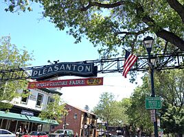
Main Street sign
Downtown panorama
Houses along First Street in historic downtown area
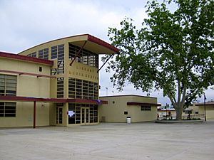
Veterans Memorial Building
Farmers' Market
Ruby Hill Winery
Quarter horse racing at the Alameda County Fair
|
||
|
||
| Motto(s):
The City of Planned Progress
|
||
| Country | United States | |
| State | California | |
| County | Alameda | |
| Mexican land grant | 1839 | |
| Established | 1869 | |
| Incorporated | June 18, 1894 | |
| Named for | General Alfred Pleasonton | |
| Government | ||
| • Type | Council–manager | |
| Area | ||
| • Total | 24.27 sq mi (62.85 km2) | |
| • Land | 24.12 sq mi (62.47 km2) | |
| • Water | 0.15 sq mi (0.38 km2) 0.63% | |
| Elevation | 351 ft (107 m) | |
| Population
(2020)
|
||
| • Total | 79,871 | |
| • Density | 3,290.9/sq mi (1,270.82/km2) | |
| Time zone | UTC−8 (PST) | |
| • Summer (DST) | UTC−7 (PDT) | |
| ZIP Codes |
94566, 94568, 94588
|
|
| Area code(s) | 925 | |
| FIPS code | 06-57792 | |
| GNIS feature IDs | 277578, 2411441 | |
Pleasanton is a city in Alameda County, California, United States. It's located in the Amador Valley, which is part of the San Francisco Bay Area. The city had a population of 79,871 people in 2020. In 2005 and 2007, Pleasanton was even named one of the wealthiest mid-sized cities in the U.S.
Many big companies have their main offices in Pleasanton. These include Safeway, Workday, Ellie Mae, and Veeva Systems. Other large employers are Kaiser Permanente and Oracle. Even though Oakland is the main county seat, some county offices are in Pleasanton. The Alameda County Fairgrounds are also here, where the county fair happens every summer. You can also find Pleasanton Ridge Regional Park on the west side of town.
Contents
History of Pleasanton
Early Valley Life
The Amador Valley, where Pleasanton is located, was once home to Native American tribes. These tribes were part of the Ohlone language group and mostly spoke Chochenyo. Around the 1770s, about seven different tribes lived in the valley. Each tribe had its own area, living in villages of 60 to 90 people. The total population of the valley was around 2000 to 2500 people.
Spanish and Mexican Times
The first Spanish explorers arrived in the Amador Valley in 1772. Native people from the valley started joining Mission Santa Clara in the 1790s. More joined after Mission San Jose was founded in 1797.
After Mexico became independent from Spain in 1821, the missions were closed down. The Native people were freed, and the land was given out as large farms called ranchos to Spanish and Mexican settlers. Pleasanton is built on land that was once part of the Rancho Valle de San José and Rancho Santa Rita ranchos.
Alisal Settlement
Before Pleasanton was officially founded in the 1850s, there was a settlement called Alisal. It was located on the Rancho Santa Rita land, near an old Native American village. The Francisco Solano Alviso Adobe was built there in 1844 and is one of the oldest houses in the valley. It's still standing today in the Alviso Adobe Community Park.
Alisal was known as "The Most Desperate Town in the West." It was a place where bandits and outlaws would hide after the California Gold Rush began. Shootouts on Main Street were common. Famous bandits like Claudio Feliz and Joaquin Murrieta would rob gold prospectors and then seek safety in Alisal. Today, Alisal Elementary School is named after this early settlement.
How Pleasanton Got Its Name
The Rancho Valle de San José land was given to the Bernal family and their relatives. To protect their land from people trying to settle on it during the California gold rush, the Bernal family moved to their ranch. John Kottinger, an Austrian immigrant and lawyer who married into the family, also lived there.
Pleasanton got its name in the 1860s. John W. Kottinger, a local judge, named it after his friend, Major General Alfred Pleasonton from the Union army. A small mistake by a clerk in Washington, D.C., led to the spelling we use today.
20th Century Changes
In 1917, the movie Rebecca of Sunnybrook Farm, starring Mary Pickford, was filmed in Pleasanton. The town was also home to Phoebe Hearst, who lived in a huge 50-room mansion on a 2,000-acre estate. This estate is now the Castlewood Country Club.
After World War II, Pleasanton changed a lot. It went from being a farming and ranching town to a place where people lived and worked in offices. Many companies built their main offices here as the Bay Area grew.
Geography and Climate
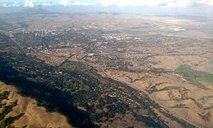
Pleasanton is next to the cities of Hayward, Livermore, and Dublin. The city covers about 24.3 square miles, with most of it being land.
On the east side of town, you'll find Shadow Cliffs Regional Park. It has a lake where you can swim, fish, and go boating. On the west side are the Pleasanton Ridge and Augustin Bernal Park, which are great for outdoor activities. Pleasanton is also located along the path of the historic First transcontinental railroad.
Pleasanton's Weather
Pleasanton has a Mediterranean climate. This means it has hot, dry summers and mild, cool winters with some rain. The highest temperature ever recorded was 115°F (46°C) in 1950. The lowest was 17°F (-8°C) in 1990.
| Climate data for Pleasanton, California | |||||||||||||
|---|---|---|---|---|---|---|---|---|---|---|---|---|---|
| Month | Jan | Feb | Mar | Apr | May | Jun | Jul | Aug | Sep | Oct | Nov | Dec | Year |
| Record high °F (°C) | 75 (24) |
80 (27) |
88 (31) |
96 (36) |
104 (40) |
113 (45) |
112 (44) |
112 (44) |
115 (46) |
106 (41) |
90 (32) |
79 (26) |
115 (46) |
| Mean daily maximum °F (°C) | 58 (14) |
62 (17) |
65 (18) |
71 (22) |
77 (25) |
84 (29) |
89 (32) |
89 (32) |
86 (30) |
78 (26) |
65 (18) |
57 (14) |
73 (23) |
| Mean daily minimum °F (°C) | 37 (3) |
40 (4) |
42 (6) |
44 (7) |
48 (9) |
53 (12) |
55 (13) |
55 (13) |
53 (12) |
48 (9) |
42 (6) |
37 (3) |
46 (8) |
| Record low °F (°C) | 17 (−8) |
23 (−5) |
22 (−6) |
29 (−2) |
32 (0) |
30 (−1) |
36 (2) |
40 (4) |
35 (2) |
29 (−2) |
23 (−5) |
18 (−8) |
17 (−8) |
| Average precipitation inches (mm) | 2.99 (76) |
2.77 (70) |
2.47 (63) |
0.96 (24) |
0.43 (11) |
0.09 (2.3) |
0.03 (0.76) |
0.08 (2.0) |
0.24 (6.1) |
0.84 (21) |
1.88 (48) |
2.04 (52) |
14.48 (368) |
| Source 1: The Weather Channel | |||||||||||||
| Source 2: Weather Atlas | |||||||||||||
People of Pleasanton
| Historical population | |||
|---|---|---|---|
| Census | Pop. | %± | |
| 1870 | 350 | — | |
| 1880 | 600 | 71.4% | |
| 1890 | 984 | 64.0% | |
| 1900 | 1,100 | 11.8% | |
| 1910 | 1,254 | 14.0% | |
| 1920 | 991 | −21.0% | |
| 1930 | 1,237 | 24.8% | |
| 1940 | 1,278 | 3.3% | |
| 1950 | 2,244 | 75.6% | |
| 1960 | 4,203 | 87.3% | |
| 1970 | 18,328 | 336.1% | |
| 1980 | 35,160 | 91.8% | |
| 1990 | 50,533 | 43.7% | |
| 2000 | 63,654 | 26.0% | |
| 2010 | 70,285 | 10.4% | |
| 2020 | 79,871 | 13.6% | |
| 2023 (est.) | 76,459 | 8.8% | |
| U.S. Decennial Census | |||
In 2020, the population of Pleasanton was 79,871 people. There were about 25,245 households in the city. About 42.7% of these households had children under 18 living in them. The average household size was 2.77 people.
Pleasanton's Economy
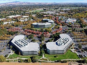
Pleasanton saw a big economic growth starting in the early 1980s. This was mainly due to the creation of many business parks, like the large Hacienda Business Park. These parks have many office buildings. Pleasanton has been very good at attracting major company headquarters.
Some of the companies with their main offices here include Safeway, Blackhawk Network Holdings, Workday, and Simpson Manufacturing. Even when office space was less busy in the early 2000s, Pleasanton's economy stayed strong.
Many other companies also have large offices in Pleasanton, such as Hitachi High Technologies America, Inc., Cisco Systems, and Clorox.
For shopping, Pleasanton has a big regional mall called Stoneridge Shopping Center and many other shopping areas. Pleasanton is also famous for its downtown area. It has many great restaurants, unique shops, and service businesses. Main Street was redesigned in the 1990s to make it more friendly for people walking and eating outdoors.
In 2005, the average household income in Pleasanton was $101,022. This was the highest income for any city of its size. By 2013, the average income had grown to $121,622.
Top Employers in Pleasanton
As of July 2024, these are some of the biggest employers in Pleasanton:
| # | Employer | Employees |
|---|---|---|
| 1 | Workday | 5,399 |
| 2 | Kaiser Permanente | 3,019 |
| 3 | Pleasanton Unified School District | 1,373 |
| 4 | Safeway | 1,348 |
| 5 | Stanford Health Care Tri-Valley | 1,124 |
| 6 | Veeva Systems | 945 |
| 7 | Roche Molecular Diagnostics | 927 |
| 8 | Oracle Corporation | 882 |
| 9 | 10x Genomics | 600 |
| 10 | Life Technologies | 579 |
| 11 | ICE Mortgage Technology | 548 |
| 12 | SMM Facilities Inc | 442 |
| 13 | Blackhawk Network Holdings | 383 |
| 14 | Clorox Services Company | 369 |
| 15 | Sensiba San Filippo, LLP | 331 |
Arts and Culture
Pleasanton has many regular events for its community. Every Saturday morning, a farmers' market is held on Angela Street, just off Main Street. There are also several parades throughout the year, celebrating holidays like Christmas, Memorial Day, and Veterans Day.
Fun Events and Festivals
Friday Concerts in the Park
The Pleasanton Downtown Association hosts Friday Concerts in the Park. Every Friday from June to September, different local bands play music in the evenings at Lions' Wayside Park. These concerts are free and attract many people.
Alameda County Fairgrounds
The Alameda County Fairgrounds is a large 270-acre area in Pleasanton. It's where the yearly Alameda County Fair has been held since 1912. Many other trade shows and community events also take place here, including the Scottish Games every Labor Day weekend.
The Pleasanton Fairgrounds Racetrack was built in 1858, making it the oldest 1-mile horse racing track in the United States. There's also a 3,000-seat outdoor theater and a nine-hole golf course inside the track. The Alameda County Central Railroad Society has a model train exhibit at the fairgrounds that has been there since 1959.
Historic Buildings
Pleasanton's downtown area has been well-preserved, so you can see many examples of old buildings. These buildings show different styles from the mid-19th century, like Gothic Revival, Pioneer, Italianate, and Queen Anne.
One famous building downtown is the Kolln Hardware building at 600 Main Street. It was built in 1890 and always housed a hardware store until 2004. Now, a bank is located there.
Firehouse Arts Center
The Firehouse Arts Center opened in 2010 and is a hub for culture and art in Pleasanton. It has a 221-seat theater, the Harrington art gallery, and classrooms for art and drama.
Hacienda del Pozo de Verona
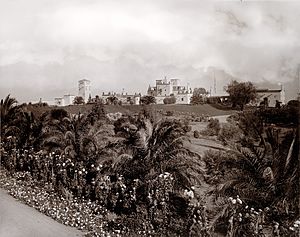
The Hacienda del Pozo de Verona (The House of the Wellhead of Verona) was a beautiful estate that burned down in 1969. It was built in 1898 for Phoebe Hearst by architect A. C. Schweinfurth. Phoebe Hearst later had it remodeled and expanded by architect Julia Morgan to be her main home. The estate was named after a round, carved marble wellhead that Phoebe and her husband bought in Verona, Italy.
Education in Pleasanton
Most public schools in Pleasanton are part of the Pleasanton Unified School District. This district was formed in 1988 when the school districts of Pleasanton and Dublin joined together.
Pleasanton has two main high schools: Amador Valley and Foothill. Both are ranked among the top public high schools in the country. There is also Village High School, which is a continuation high school. The district also includes three middle schools (Thomas S. Hart, Pleasanton, and Harvest Park) and nine elementary schools.
Media and News
The Pleasanton Weekly is the local newspaper for the city. Tri-Valley Community Television also has its main station in Pleasanton.
Getting Around Pleasanton
Pleasanton is located where two major highways meet: I-580 and I-680. These highways follow old paths used by Native American tribes for trading long ago. When the Hacienda Business Park was being built, workers found many old tribal tools and remains, showing how important these paths were.
Public Transportation
The city has two stations for the Bay Area Rapid Transit (BART) train system:
- Dublin/Pleasanton station, which is the end of the line.
- West Dublin/Pleasanton station, located near the Stoneridge Shopping Center.
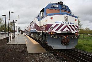
The Altamont Corridor Express (ACE) train also stops near downtown Pleasanton at Pleasanton Station.
The Wheels (LAVTA) bus system provides most of the bus service in Pleasanton. It connects the city to Livermore and Dublin, as well as to the train stations.
Airports Near Pleasanton
The closest airport to Pleasanton is Livermore Municipal Airport. It's mainly used for private and charter flights, not regular passenger flights. For commercial flights, the closest airports are San Jose International Airport (reachable by the ACE train) and Oakland International Airport (reachable by BART). Most international flights for the region fly out of San Francisco International Airport, which you can also get to using BART.
Famous People from Pleasanton
Many notable people have lived in Pleasanton, including:
- Scott Adams, who created the Dilbert comic strip.
- Brandon Crawford, a professional baseball player for the San Francisco Giants.
- Paula Creamer, a professional golfer.
- John Madden, a famous football coach and sportscaster.
- William E. Moerner, who won the Nobel Prize in Chemistry in 2014.
- Jim Perry, a well-known game show host.
- Stephen Piscotty, a professional baseball player for the Oakland Athletics.
- Gabrielle Union, a film and television actress.
- David Yost, an actor from Mighty Morphin Power Rangers.
Sister Cities
Pleasanton has sister cities around the world:
 Blairgowrie and Rattray, Scotland, UK
 Fergus, Ontario, Canada
 Tulancingo, Mexico
See also
 In Spanish: Pleasanton para niños
 | Audre Lorde |
 | John Berry Meachum |
 | Ferdinand Lee Barnett |


