Guadalupe River Trail facts for kids
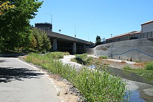
The Guadalupe River Trail is a cool path for walking and biking in San Jose, California. It's about 11-mile (18 km) long and follows the Guadalupe River. The trail has two separate parts right now: a shorter one and a longer one. Lots of people use this paved trail for fun, like riding bikes or going for a run. It's also great for getting around, as it connects many neighborhoods directly to Downtown San Jose.
In 2009, the Guadalupe River Trail was named a special National Recreation Trail.
Contents
Explore the Guadalupe River Trail!
The Guadalupe River Trail is split into two main sections. Let's explore where they go!
Two Parts of the Trail
The Southern Part
The southern end of the trail starts near Almaden Lake Park in the Almaden Valley neighborhood. This part is about 1.4 miles (2.3 km) long.
From Almaden Lake Park, the trail goes north along the river. It goes under Blossom Hill Road and then under the big highway bridges of State Route 85. This section ends at Chynoweth Avenue, close to William H. Cilker Park. It also passes very near the Westfield Oakridge Mall, which is a popular shopping spot! This southern part is not connected to the rest of the trail yet.
The Northern Part
The longer northern part of the trail begins just south of Interstate 280 at West Virginia Street. From there, it follows the river north. You'll go under several streets in Downtown San Jose, like Woz Way, West San Carlos Street, Park Avenue, San Fernando Street, and Santa Clara Street.
As you continue north, you'll cross St. John Street and Julian Avenue. This part of the trail goes through fun city parks like Children's Discovery Park and McEnry Park. It also runs right next to the SAP Center, where you might catch a hockey game or a concert!
The trail keeps going north, crossing Coleman Avenue, Taylor Street, and Hedding Street. It also goes under Interstate 880. Along this section, you'll pass through the Guadalupe River Park and Gardens. This is a huge area with lots of parks and gardens next to State Route 87.
Further north, the trail runs along the edge of Mineta San Jose International Airport. You'll go under Airport Parkway, U.S. Route 101, Trimble Drive, Montague Expressway, Tasman Drive, and State Route 237. This newest part of the trail opened on April 20, 2013. This section of the trail goes by Levi's Stadium, which is home to the San Francisco 49ers football team, and the Ulistac Natural Area. It also connects to the Highway 237 Bikeway.
The very northern end of the trail is at Gold Street in the Alviso neighborhood.
Images for kids
-
The logo for a National Recreation Trail
 | Isaac Myers |
 | D. Hamilton Jackson |
 | A. Philip Randolph |


