
Point Reyes facts for kids


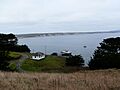
Point Reyes (pronounced RAY-iss) is a famous piece of land on the Pacific coast in Northern California. It's a popular spot for tourists. This area is in Marin County, about 30 miles (48 km) northwest of San Francisco. When people say "Point Reyes," they often mean the whole Point Reyes Peninsula. This peninsula is surrounded by Tomales Bay to the northeast and Bolinas Lagoon to the southeast. Most of this land, including the main headlands, is protected as part of Point Reyes National Seashore.
Contents
About Point Reyes
The cape of Point Reyes helps protect Drakes Bay on its southern side. A large water area called Drakes Estero drains much of the headland. Both Drakes Bay and Drakes Estero are named after the English explorer Sir Francis Drake. He might have brought his ship, the Golden Hinde, here for repairs in June 1579.
A ridge called Inverness Ridge runs through the peninsula, with forested peaks reaching about 1,400 feet (430 m) high. West of this ridge, the land becomes flatter and has more scrub plants. Wildfires, like the Mount Vision fire in 1995 and the Woodward fire in 2020, have burned parts of Inverness Ridge. The nearby town of Point Reyes Station is also named after Point Reyes.
History of Point Reyes

The Coast Miwok People
When Europeans first arrived, the Coast Miwok lived in the Point Reyes area. They had over a hundred camps on the peninsula, and their population was around 3,000. They were seasonal hunters and gatherers, meaning they moved to find food throughout the year. They ate fish, clams, mussels, and crab. They also hunted deer, elk, and birds using spears and bows.
The Coast Miwok used many different plants from Point Reyes. Acorns were a very important food. They could be stored in dry places to eat when other foods were scarce.
The Coast Miwok met European explorers from time to time. They continued to live here until the late 1700s. That's when the Spanish built Mission San Rafael. Missionaries then came to Point Reyes to ask the Miwok to move to the mission. Sadly, these missionaries also brought diseases that caused many deaths, fewer births, and more infant deaths among the Miwok.
Today, descendants of the Coast Miwok have formed the Federated Indians of Graton Rancheria. In 2000, the U.S. government officially recognized their tribe. They have almost 500 members who are bringing back traditional customs and ceremonies. These events are often held at Kule Loklo, which means "Valley of the Bear." It's a replica Miwok village in Point Reyes National Seashore.
Early Spanish Explorers

On November 13, 1542, Spanish explorer Juan Rodríguez Cabrillo saw and named "Cabo de Pinos" (Point Reyes). But he missed the entrance to San Francisco Bay. Sailors would miss this bay for over 200 years because of the thick fog common in the area.
Another Spanish explorer, Sebastián Vizcaíno, named the land Punto de los Reyes ("Kings' Point"). His ship, the Capitana, anchored in Drakes Bay on January 6, 1603. This day is known as the Day of the Three Kings (Epiphany), which is the end of the 12 Days of Christmas. This is where the name Point Reyes comes from.
Sir Francis Drake's Visit

Even though other explorers and Spanish trading ships passed by Point Reyes, the landing by Sir Francis Drake is a very famous part of its early history. Some experts believe he landed near here on June 17, 1579. He called the land Nova Albion (New England) during his trip around the world.
The place where he supposedly landed is now a National Historic Landmark called Drake's Cove at Point Reyes National Seashore. Drake's chaplain wrote about the friendly welcome Drake and his men received from the Coast Miwok people. He also described the land, wildlife, and the frequent fog that covers the peninsula in summer.
The Shipwreck of San Agustin


Spain was very interested in finding a safe harbor on the California coast because their trade between the Philippines and Mexico was growing. Many believe Drake's discovery of a harbor here made Spain order Sebastian Rodriguez Cermeno, a Portuguese captain working for Spain, to explore the California coast in 1595.
Cermeno was sailing the San Agustin, a large ship called a Manila galleon. It was full of valuable Chinese silks, spices, and porcelain heading to Acapulco. Cermeno faced one of the first of many shipwrecks at Point Reyes. He also had one of the most amazing journeys to safety. Some of his crew were Filipino sailors.
Cermeno's ship was old and heavily loaded, and his crew was tired. He anchored near the Point Reyes inlet, now called Drakes Estero. Within a few days, a November storm hit. The ship was pushed onto the beach and pounded by huge waves. It soon broke apart, killing several men and spilling its precious cargo. Some of this cargo was later collected and used by the local Coast Miwok people.
Cermeno managed to save a small, open boat, like a large canoe. He loaded it with the 70 surviving crew members to start the long trip home. After a very difficult two-month journey, Cermeno and all his crew arrived safely in Acapulco in January 1596. Even though his journey was amazing, he wasn't celebrated. He had lost his ship and cargo, and he hadn't found the safe harbor he was ordered to find.
Spanish Missions and Land Grants
Spain didn't pay much attention to California until the late 1700s. By then, trade was important, and it was clear that the country controlling California's harbors would become very rich. When England, France, and Russia started to show interest in California's coast, the King of Spain decided to protect it.
To find places for military forts (presidios) and missions, an expedition of 67 men and 100 mules left San Diego in 1769. Led by Gaspar de Portolá, the governor of Baja California, they walked north. They were looking for Monterey Bay, but they found San Francisco Bay instead. Before that, from a high point south of Pacifica, they saw Point Reyes and the Farallon Islands. They couldn't go further north toward Point Reyes because the Golden Gate and San Francisco Bay blocked their way, and they had no boats.
After Portolá's expedition, Spain began building presidios and missions. By 1817, Mission San Rafael was built. Priests started traveling to Point Reyes to encourage the Coast Miwok to move to the mission. Many Miwok did move, but they didn't do well. Serious outbreaks of smallpox and pneumonia killed many. Others got sick from colds and measles. Birth rates dropped, and death rates increased quickly. Since the missions needed healthy workers, these illnesses led to their decline.
Mexico became independent from Spain in 1821 and took control of California. Most mission land was divided into large land grants, mainly used for cattle ranching. Point Reyes itself and Drake's Bay were not very good for cattle. So, in 1843, they became part of Rancho Punta de los Reyes Sobrante (Sobrante means "leftover"). This happened just a few years before California became part of the United States, which caused many years of confusion and land disputes.
Rancho Tomales y Baulines
When the Spanish missions in California were closed down, almost all of Point Reyes was given to Rafael Garcia. He was a corporal in the Mexican Army and received about 8,911 acres in March 1836. This land was called Rancho Tomales y Baulines. It's believed to have included the whole Olema Valley, from Tomales Bay to Bolinas Lagoon, but its exact borders were never clear. Garcia didn't survey his land as Mexican law required. This led to confusion and long court battles when the rancho was later broken up.
Unlike many ranch owners, Garcia actually lived on his land. He built a home near what is now the National Seashore's Bear Valley Headquarters. He had a home for his family and a base for his large ranching business. He owned about 3,000 cattle, 400 horses, and many sheep and hogs.
When Mexico lost California to the United States, Garcia continued to do well. After the American takeover, the 1849 Gold Rush brought many gold seekers. Before, his wild cattle were only valuable for their hides and fat. Now, he could sell them to feed hungry gold miners, earning as much as $35 for each cow.
Unfortunately for Garcia, these good years ended quickly. In 1851, the United States passed a law requiring ranch owners to prove they legally owned their land grants. The Garcias kept ranching, but their land slowly disappeared. After 15 years of lawsuits, court appearances, and high legal fees, Garcia had sold all but 3,085 acres of his land at very low prices.
Confusing Land Borders
Even though Garcia thought he owned almost all of Point Reyes, another land grant was given out the same year, 1836. It went to an Irishman named James Berry, who had become a Mexican citizen and an army colonel. This land grant was also in the Olema Valley. To make things more confusing, Berry soon left the area and hired Garcia to manage it.
Just two years later, Berry illegally sold almost 9,000 acres of his land to a sea captain named Joseph Snook. Mexican law clearly forbid this, and it could mean losing the entire land grant. Berry wanted to keep the sale a secret, but Snook wanted legal ownership. Snook found out that the only way to get legal title was to officially report Berry for not living on the land, which was required. Snook succeeded and gained legal ownership of the land he had bought illegally. He then stocked it with 56 cattle and, like Berry, hired Garcia to manage it. Three months after he won legal title, he illegally sold it again.
This started a confusing series of sales and transfers that no one could sort out. Finally, in 1844, the ranch owners themselves asked the Mexican government to investigate and clarify who owned what. Not much was clarified. It wasn't until the United States took over California and required ranch owners to do surveys and go to court to keep their land that the confusing sales were untangled. Most ranch owners eventually proved ownership. But by this time, they had run out of money and were forced to sell their land to pay for surveys and huge legal fees. American business people were happy to take advantage of this. With cash, they bought these large Mexican land grants, often paying less than $2 per acre. This began Point Reyes's next chapter as a major dairy farming area.
The Shafter Family and Dairies
The way people settled Point Reyes changed forever when the Shafter family bought land there. Brothers Oscar Shafter and James Shafter started very successful large-scale dairy farms. Today, 13 of the 31 dairies they started are still running.
Oscar was the first to arrive. He was a lawyer from Vermont who wanted to make a fortune and return home quickly. He left his family to go to San Francisco, which was booming. Being away became too hard when his two youngest children died. Still wanting wealth, he convinced his wife and their surviving daughter to join him. They did well, and Oscar had four more daughters born in California. Oscar soon convinced his younger brother, James, also a lawyer, to join him. They became known as top experts in land title lawsuits in San Francisco.
Using their knowledge of land titles, they began buying land in Point Reyes. When Oscar's oldest daughter married Charles Webb Howard, who was also a lawyer, the three partnered up. They worked to turn the windy Point Reyes into successful dairy farms.
They wanted to supply the growing city of San Francisco with butter. By 1857, the partners started fencing large areas of land (eventually 40 miles of fences). They built homes and barns and stocked the dairies with pure-bred bulls and rams, some costing over $1,400. By 1868, they had 3,500 cows on 17 dairies. They were producing over 700,000 pounds of butter each year. All their dairies were run by renters. When the hardest working renters tried to buy the dairies they worked on, they couldn't. Many eventually left and started some of California's other big dairies.
Even with their great hopes for Point Reyes, they had many money worries. After they passed away, their children tried to keep the dairies going. But they struggled to stop the decline because of aging ranches, sick herds, and often unhappy renters. Finally, in 1937, an era ended when the last of the Shafter family's land was sold. This brought in new owners to Point Reyes.
The Towns of Point Reyes
There are four towns on or near Point Reyes: Bolinas, Olema, Inverness, and Point Reyes Station.
During the Spanish and Mexican War, Bolinas's remote lagoon was used by American, British, and Russian smugglers. They wanted to avoid taxes and rules. Later, when the Gold Rush of 1849 created a huge demand for wood, Bolinas became a port for nearby logging operations and, for a short time, for quarrying limestone. By the late 1960s, Bolinas became home to many hippies. Many had left San Francisco's Haight-Ashbury for a quieter place. In 1971, they stopped a plan that would have allowed 28,000 people to live there. They did this by stopping new homes and preventing the main road from being widened. Instead, a plan was approved that focused on farming, fishing, and small businesses for the town's economy.

As the Shafter dairies grew, it became clear that Point Reyes needed a central town for supplies, services, and fun. In 1857, a hotel and saloon were built, and the young town was named "Olema," which means "coyote" in the Coast Miwok language. Within three years, it became the main business center for the region. It had a post office, grocery store, saloon, butcher, stable, and two hotels. By 1867, a wagon road from San Rafael was built, and a stagecoach arrived twice a week. Druids Hall was finished in 1885. This Olema chapter of the United Ancient Order of Druids helped each other, grew intellectually, and cared about society. It also worked as a group against alcohol.
The Shafters worked hard to get a railroad built to Point Reyes. When it was finally built, it bypassed Olema and ended two miles away. When the first train arrived in early 1875, Point Reyes Station was just a cow pasture. By 1880, it had a hotel, saloon, blacksmith shop, stable, butcher shop, and school. Its post office was finished in 1882, and its first store opened in 1883. When the railroad era ended, growth was slow. It wasn't until after World War II that a medical center and a shopping center (with a drugstore, dentist, coffee shop, and library) were built. The train station became the local post office, and the old engine house became a community center. In the 1970s, hippies started small businesses in empty houses and shops. At the same time, the Coast Guard bought 30 acres of land, once used for cattle, and built military housing. Point Reyes Station continues to be the region's supply and service center. It's a popular place with shops, restaurants, and an annual music festival.
20th Century Changes
As developers and loggers made plans for the area, a 1956 study by the National Park Service (NPS) suggested buying the peninsula for a seashore park. By 1958, a report recommended that the NPS immediately buy 35,000 acres. There was a big debate: environmentalists liked the idea, but ranchers were against it. A compromise was reached. It allowed ranchers to lease their land and continue dairy farming while sharing the area with tourists and park activities. On September 13, 1962, President John F. Kennedy signed the bill. It allowed the purchase of 53,000 acres and set aside $13 million. Eventually, 18,000 acres bought by the NPS were leased back to ranchers.
Working with the NPS, volunteers have restored and now maintain a historic coastal radio station, KSM (formerly KPH), at Point Reyes. It is still one of the few commercial Morse code stations operating in the world, and the only one in the U.S.
During the Cold War, submarines repaired at Mare Island Naval Shipyard were tested in the shallow waters off Point Reyes. Navy safety workers used a small monitoring hut on the peninsula to watch the submarines during these tests.
In April and May 1979, parts of John Carpenter's movie The Fog were filmed at the Point Reyes Lighthouse and in the small town of Inverness.
As of 2015, the Drakes Bay Oyster Company stopped its operations, and most of its structures were removed. This happened because their lease ended.
Animals and Plants of Point Reyes


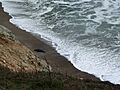
Northern Elephant Seals
In the 1700s, northern elephant seals were hunted so much that they almost disappeared by the late 1800s. People wanted their blubber (fat) to make oil. Their population may have dropped to as few as 20 animals. In 1874, a whaler named Charles Melville Scammon wrote that elephant seals lived from Baja California up to Point Reyes.
They were thought to be extinct in 1884. But then, a small group of eight was found on Guadalupe Island in 1892 by a Smithsonian expedition. Sadly, they killed seven of the eight for their collections. The elephant seals managed to survive, and the Mexican government finally protected them in 1922. After the Marine Mammal Protection Act of 1972 was passed in the U.S., their protection became even stronger. Now, their numbers have grown to over 100,000.
The first breeding pair of elephant seals was found on a sheltered beach below Point Reyes' Chimney Rock in 1981. Their population has grown quickly, by about 16% each year. Now, there are between 1,500 and 2,000 elephant seals there each winter.
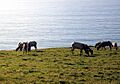
Tule Elk
California's native tule elk were hunted until only a few animals were left in California's Central Valley. Joseph Warren Revere, a grandson of American hero Paul Revere, wrote in his book that he saw 400 elk in one herd at Point Reyes in the 1840s. Stephen J. Richardson, whose father was a Marin County pioneer, wrote, "I think the largest herd in the world roamed over the deep grasslands of Point Reyes...I fully believe there were a thousand elk in one herd."
Even though they had completely disappeared from Point Reyes, ten elk were brought back to Point Reyes in 1978 from the San Luis National Wildlife Refuge. By 2009, the population grew to over 440 elk at Tomales Point, which has 2,600 acres of coastal scrub and grasslands. In 1999, 100 elk from Tomales Point were moved to the Limantour wilderness area and above Drakes Beach.
The drought from 2012–2015 was a threat to the elk kept north of a fence on Tomales Point. Nearly half of them died from lack of water. In 2012, there were 540 elk, then only 357 in 2013, and by 2014, only 286. In August and September 2020, drought and wildfires again threatened the Tomales Point elk. This led some conservationists to illegally bring water to the elk north of the fence.
In a 1977 study, half of the ten Point Reyes dairy cattle herds were infected with a disease called paratuberculosis (also known as Johne's Disease). This disease also affected other deer. Tule elk became infected with this disease within two years of being brought back to the peninsula. This disease came to North America with cattle from Europe and Asia. Point Reyes cattle have also infected the tule elk population.
Non-native axis deer and fallow deer (originally from India and Asia Minor) used to live at Point Reyes. They competed with the native black-tailed deer. A doctor bought the axis and fallow deer from the San Francisco Zoo in 1948 for his 5,000-acre hunting club. This land later became part of the national seashore.
Plants and Birds
Plants native to Point Reyes include bishop pine, Douglas-fir, coyote brush, monkeyflower, poison oak, California blackberry, salal, and coast redwood, among others. Nearly 490 different types of birds have been seen in the park and in the nearby waters. Point Reyes National Seashore is one of the best places in the United States for birdwatching. It's also one of the best places to watch northern elephant seals in the winter months. More than 70,000 acres (280 km2) of habitat are home to an amazing variety of bird life. There are also popular oyster farms on and near the peninsula.
Geology of Point Reyes

The entire Point Reyes Peninsula is a piece of land that has moved northward because of the San Andreas Fault. Its center is made of granite rock, which is different from the land east of Tomales Bay. The granite rocks that form the peninsula were once connected to the Tehachapi Mountains, which are about 350 miles (560 km) south of here. During the 1906 San Francisco earthquake, Point Reyes moved north 21 feet (6.4 m)!
Point Reyes is bordered to the east by the San Andreas Fault, which runs directly under Tomales Bay. The Point Reyes Peninsula sits on the Pacific Plate, while the rest of Marin County is on the North American Plate. The peninsula is part of something called the Salinian Block. This is a piece of the southernmost Sierra Nevada mountain range that was moved north from Southern California by the San Andreas fault. Simply put, the peninsula is made of three main parts: very old granite rocks, younger sedimentary rocks on top, and even younger marine terrace deposits on the southern part.
Climate at Point Reyes
The U.S. Weather Bureau (now the National Weather Service) collected weather data at the Point Reyes lighthouse from 1914 to 1943. Temperatures were recorded until 1926. Based on those records, average January temperatures were between 45.1°F (7.3°C) and 54.1°F (12.3°C). Average September temperatures were between 51.7°F (10.9°C) and 61.0°F (16.1°C). The highest temperature ever recorded was 90°F (32°C) on October 3, 1917. The lowest was 31°F (-1°C) on January 19, 1922.
The average yearly rainfall was 17.05 inches (433 mm). The wettest year was 1941, with 31.37 inches (797 mm). The driest year was 1923, with only 7.32 inches (186 mm). The most rain in one month was 9.51 inches (242 mm) in December 1916. The most rain in 24 hours was 2.65 inches (67 mm) on December 15, 1929. Today, weather observations are taken automatically at the lighthouse. Weather information is also collected in nearby Point Reyes Station and published in local newspapers.
| Climate data for Point Reyes (1914–1943; temperatures 1917–1926) | |||||||||||||
|---|---|---|---|---|---|---|---|---|---|---|---|---|---|
| Month | Jan | Feb | Mar | Apr | May | Jun | Jul | Aug | Sep | Oct | Nov | Dec | Year |
| Record high °F (°C) | 78 (26) |
75 (24) |
76 (24) |
81 (27) |
80 (27) |
84 (29) |
75 (24) |
72 (22) |
88 (31) |
90 (32) |
79 (26) |
70 (21) |
90 (32) |
| Mean daily maximum °F (°C) | 54.2 (12.3) |
54.1 (12.3) |
53.8 (12.1) |
54.5 (12.5) |
54.4 (12.4) |
56.7 (13.7) |
57.6 (14.2) |
57.9 (14.4) |
61.0 (16.1) |
61.0 (16.1) |
59.4 (15.2) |
55.4 (13.0) |
56.7 (13.7) |
| Mean daily minimum °F (°C) | 45.1 (7.3) |
45.9 (7.7) |
45.4 (7.4) |
46.3 (7.9) |
46.7 (8.2) |
48.3 (9.1) |
49.4 (9.7) |
50.4 (10.2) |
51.2 (10.7) |
50.7 (10.4) |
49.9 (9.9) |
46.8 (8.2) |
48.0 (8.9) |
| Record low °F (°C) | 31 (−1) |
38 (3) |
35 (2) |
39 (4) |
40 (4) |
40 (4) |
47 (8) |
45 (7) |
47 (8) |
47 (8) |
43 (6) |
34 (1) |
31 (−1) |
| Average precipitation inches (mm) | 3.41 (87) |
3.05 (77) |
1.94 (49) |
1.23 (31) |
0.66 (17) |
0.25 (6.4) |
0.04 (1.0) |
0.03 (0.76) |
0.36 (9.1) |
1.03 (26) |
1.73 (44) |
3.32 (84) |
17.05 (432.26) |
| Source: Western Regional Climate Center | |||||||||||||

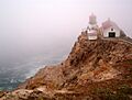
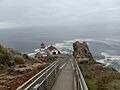
Fog at the Lighthouse
It can be very foggy and windy at the lighthouse during certain times of the year. To work well, the lighthouse had to be built below the usual high fog. When it's foggy, you can't even see the lighthouse from the top of the approximately 300 steps you need to walk down to reach it.
The lighthouse is very important in such a foggy area. There's no beach to wash up on; it's on a rocky cliff. Day or night, the light might be the only thing ships can see.
Fun Things to Do at Point Reyes
The Point Reyes peninsula is a popular place for fun activities for people from the nearby San Francisco Bay Area. Many people enjoy hiking on its many trails and sea kayaking along the shores of Tomales Bay and the coast. There are almost 150 miles (240 km) of trails, including the popular Bear Valley Trail, which starts from the Visitor Center.
Point Reyes National Seashore is one of the best places in the United States for birdwatching. It's also one of the best places to watch northern elephant seals in the winter months. More than 70,000 acres (280 km2) of habitat are home to an incredible variety of birds. There are also popular oyster farms on and near the peninsula.
Images for kids
-

Stairway to Point Reyes Lighthouse
-
Point Reyes Lighthouse in fog
-
Tule elk grazing by the seaside
-
An elephant seal on the beach
-
Point Reyes on a foggy day
-
Point Reyes seashore
-
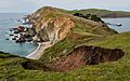
Coastline as seen from Chimney Rock


See also
 In Spanish: Punta Reyes para niños
