
Golden Gate facts for kids
Quick facts for kids Golden Gate |
|
|---|---|
| Chrysopylae Boca del Puerto de San Francisco |
|

A map showing the location of the Golden Gate strait
|
|

Golden Gate
Location in San Francisco Bay Area
|
|

Perspective view looking southwest over the Golden Gate Bridge toward the Pacific Ocean.
|
|
| Location | Between San Francisco Peninsula and Marin Headlands |
| Coordinates | 37°49′N 122°30′W / 37.81°N 122.50°W |
| Type | strait |
| Max. width | 3 miles (4.8 km) |
| Min. width | 1.1 miles (1.8 km) |
| Max. depth | 115 meters (377 ft) |
| Settlements | San Francisco, CA |
The Golden Gate is a famous narrow waterway, called a strait, on the west coast of North America. It connects the big San Francisco Bay to the huge Pacific Ocean. This strait is bordered by the San Francisco Peninsula on one side and the Marin Peninsula on the other. Since 1937, the amazing Golden Gate Bridge has stretched across it. The land and water around the Golden Gate are part of the Golden Gate National Recreation Area, a special park.
Contents
How the Golden Gate Was Formed
During the last Ice Age, the ocean level was much lower. The strong waters from the Sacramento River and San Joaquin River flowed into the ocean. These rivers, fed by melting glaciers, carved a deep channel through the solid rock.
This is how the Golden Gate strait became so deep. Today, it is known for its strong tidal currents coming in from the Pacific Ocean. You might even see small whirlpools and eddies (swirling water) in its waters.
Weather at the Golden Gate


The Golden Gate is often covered in fog, especially in the summer. This happens because hot air rises from California's Central Valley. This creates a low-pressure area that pulls in cool, moist air from the Pacific Ocean.
The Golden Gate is the biggest gap in the California Coast Range hills. This allows a constant, thick stream of fog to flow into the bay. The area has a mediterranean climate, meaning it has cool summers and mild winters. Temperatures do not change much throughout the year.
History of the Golden Gate

Before Europeans arrived in the 1700s, the Ohlone people lived south of the strait. The Coast Miwok people lived to the north. Their descendants still live in the area today.
Early European explorers often missed seeing the strait. This was probably because of the thick summer fog. Explorers like Juan Rodríguez Cabrillo and Francis Drake explored the coast in the 1500s. They were looking for the famous Northwest Passage, but they did not record seeing the Golden Gate.
The first time the strait was officially seen by Europeans was much later. In 1769, Sgt José Francisco Ortega was exploring the San Francisco Peninsula. He reported that he could not reach his goal because of a large strait.
On August 5, 1775, Juan de Ayala and his ship San Carlos were the first Europeans to sail through the strait. They anchored in a cove near Angel Island. This cove is now named after Ayala.
Until the 1840s, the strait was called "Boca del Puerto de San Francisco." This means "Mouth of the Port of San Francisco." On July 1, 1846, before gold was found in California, John C. Frémont gave it a new name. He called it "Chrysopylae," or "Golden Gate." He thought it would be "a golden gate to trade with the Orient."
The Golden Gate Bridge

The Golden Gate Bridge is a suspension bridge that crosses the Golden Gate. It connects the city of San Francisco to Marin County. It is part of US Highway 101 and California Route 1.
When it was finished in 1937, the Golden Gate Bridge had the longest main span of any suspension bridge in the world. It is a famous symbol of San Francisco and California. Today, eight other bridges have longer spans. However, it is still the second longest suspension bridge main span in the United States. Only the Verrazano-Narrows Bridge in New York City is longer. In 2007, it was named one of America's favorite buildings by the American Institute of Architects.
Ships and Boats at the Golden Gate
The Golden Gate strait is the main way for ships to enter and leave San Francisco Bay. This bay has some of the largest cargo ports in the United States. These include the Port of Oakland, the Port of Richmond, and the Port of San Francisco.
Many different types of boats use the Golden Gate. These include large cargo ships, barges, tankers, fishing boats, and cruise ships. Private boats, like wind-surfers and kite-boards, also use the strait. In 2014 and 2015, about 9,000 ships passed through the Golden Gate each year. The U.S. Coast Guard helps manage all this ship traffic.
To help ships navigate, there are lights on the Golden Gate Bridge. Lighthouses with lights and foghorns also guide ships. These are located at Point Bonita, Point Diablo, Lime Point, and Mile Rocks. Before the bridge was built, there was a lighthouse at Fort Point. Buoys and radar reflectors also help guide boats safely.
Gallery
-
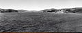
The Golden Gate as seen from off "Land's End" in Lincoln Park on the Northwest tip of the San Francisco Peninsula around 1895.
-

San Francisco Bay and Golden Gate.
-

Passing Through the Golden Gate, by William A. Coulter.
-

Golden Gate, San Francisco, California.
-
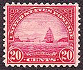
The Golden Gate, featured on a postage stamp issued in 1923.


See also
 In Spanish: Golden Gate para niños
