
Sacramento River facts for kids
Quick facts for kids Sacramento River |
|
|---|---|

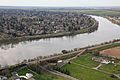
Sacramento River from the old pumping station in Sacramento, California
|
|

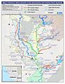
Map of the Sacramento River watershed
|
|
| Native name | Spanish: Río Sacramento |
| Other name(s) | Rio del Santísimo Sacramento |
| Country | United States |
| State | California |
| Cities | Mount Shasta, Dunsmuir, Redding, Anderson, Red Bluff, Princeton, Colusa, Davis, Sacramento, West Sacramento, Isleton, Rio Vista, Antioch |
| Physical characteristics | |
| Main source | Confluence of Middle and South Forks Near Mount Shasta, Siskiyou County 3,674 ft (1,120 m) 41°16′24″N 122°24′05″W / 41.27333°N 122.40139°W |
| River mouth | Suisun Bay Contra Costa-Solano county line 0 ft (0 m) 38°03′48″N 121°51′10″W / 38.06333°N 121.85278°W |
| Length | 400 mi (640 km), North-south |
| Basin features | |
| Basin size | 26,500 sq mi (69,000 km2) |
| Tributaries |
|
| Nicknames | Sac River, Nile of the West |
The Sacramento River is a very important river in California, United States. It flows for about 445 miles (716 km) through the northern part of California. This river is like a main highway for water, with many smaller rivers joining it. These smaller rivers are called tributaries. Some big cities like Redding and Sacramento are located along its banks.
For about 12,000 years, native people have lived near the Sacramento River. Later, in the 1800s, many new people came to the area. They were looking for gold during the famous California Gold Rush. Today, the river helps farmers grow crops by providing irrigation water. It also helps make hydroelectricity, which is power made from moving water.
Contents
Rivers Joining the Sacramento
The Sacramento River has many smaller rivers and streams that flow into it. These are called its tributaries. Here are some of the main ones:
- Cache Creek
- Putah Creek
- American River
- Feather River
- Bear River (a part of the Feather River system)
- Yuba River
- Pit River
Important Structures on the River
The Sacramento River is home to several important structures. These include dams and weirs that help manage the water.
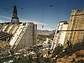
Shasta Dam
.jpg)
Shasta Dam is a very large dam built on the Sacramento River. It helps control floods and stores water for people to use. It also helps make electricity.
Red Bluff Diversion Dam

The Red Bluff Diversion Dam used to send water from the Sacramento River to farms. It was a big problem for fish trying to swim upstream. In 2013, it was replaced with a pumping plant. This new plant helps fish move more freely.
Sacramento Weir
.jpg)
The Sacramento Weir is a special structure along the river. It helps drain away extra floodwaters when the river gets too high. This protects nearby areas from flooding.
History of the River
The Sacramento River has a long and interesting history. It has been important to people for thousands of years.
Native People and Early Times
For about 12,000 years, different groups of native people lived along the Sacramento River. They used the river for food, water, and travel. The river was central to their way of life.
The California Gold Rush
In the 1800s, something big happened in California: the California Gold Rush. Many people came to the area looking for gold. The smaller rivers that flow into the Sacramento River were a main focus for gold seekers. This brought many new settlers to the region.
Transportation on the River
_01.jpeg)
During the Gold Rush, large steamboats like the Chrysopolis traveled on the Sacramento River. They carried people and goods. The river was a major way to get around in California at that time.
The River's Journey to the Ocean
The Sacramento River eventually flows into the Pacific Ocean. But it takes a few steps to get there.
Suisun Bay and the Delta
The river ends its journey in Suisun Bay. This bay is part of a larger area called the Sacramento-San Joaquin River Delta. This delta is a huge network of waterways.
Carquinez Strait

From Suisun Bay, the water flows through the Carquinez Strait. This strait is like a narrow passage. It connects the Delta and Suisun Bay to San Pablo Bay and then to San Francisco Bay. Finally, the water reaches the Pacific Ocean. This strait formed when a giant lake in the Central Valley overflowed.
Images for kids
-
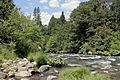
Upper Sacramento River at Castle Crags State Park
-
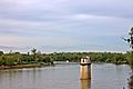
The Sacramento River running through Red Bluff, California
-
Sacramento River in Bend, California
-
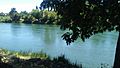
Sacramento River above Sacramento
-
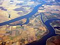
Aerial view of the Delta region, showing the Sacramento River (above) and the San Joaquin River.
-
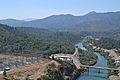
The Sacramento River below Shasta Dam
-
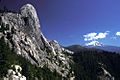
The Castle Crags, granite peaks rising above the upper Sacramento River canyon. Mount Shasta is in the distance.
-
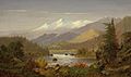
Mt. Shasta and the Sacramento River by Frederick A. Butman (1820-1871)
-
Construction work on Shasta Dam in June 1942
-
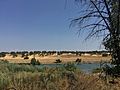
Sacramento River flowing through the Sacramento suburbs
-
Improvement in water quality throughout the Sacramento and Feather River.


.jpg)

.jpg)

See also
 In Spanish: Río Sacramento (Estados Unidos) para niños
