
Stony Creek (Sacramento River tributary) facts for kids
Quick facts for kids Stony Creek |
|
|---|---|

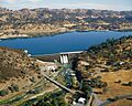
Stony Gorge Dam on Stony Creek, near Elk Creek
|
|

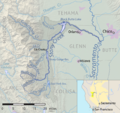
Map of the Stony Creek drainage basin
|
|
| Country | United States |
| State | California |
| Physical characteristics | |
| Main source | California Coast Ranges Mendocino National Forest, Colusa County 1,457 ft (444 m) 39°22′45″N 122°38′50″W / 39.37917°N 122.64722°W |
| River mouth | Sacramento River near Hamilton City, Glenn County 108 ft (33 m) 39°40′38″N 121°58′23″W / 39.67722°N 121.97306°W |
| Length | 73.5 mi (118.3 km) |
| Basin features | |
| Basin size | 777 sq mi (2,010 km2) |
| Tributaries |
|
Stony Creek is a 73.5-mile (118.3 km)-long river in Northern California. It flows only during certain seasons. This creek is a branch of the Sacramento River. It drains a large area of land, called a watershed, covering over 700 square miles (1,800 km2). This watershed is on the west side of the Sacramento Valley in several California counties.
Stony Creek starts in the Coast Ranges mountains. It flows north through valleys, then turns east across the Sacramento Valley. It joins the Sacramento River about 5 miles (8.0 km) west of Chico. Stony Creek is the second largest river flowing into the west side of the Sacramento River. Only Cottonwood Creek is bigger.
Stony Creek is very important for farming in the Orland area. It provides water for crops. The river is home to native rainbow trout. In the past, many steelhead fish, which travel from the ocean, used to swim up the creek to lay their eggs.
The creek got its name, "Stony Creek," because it used to carry many rocks and sediments from the mountains during floods. Today, a large dam called Black Butte Dam holds back most of this sediment. This dam was built in 1963 to help control floods. Sometimes, old maps might call it "Stoney Creek" or "Stone Creek." Long ago, it was also known as the Capay River.
Contents
The Journey of Stony Creek
Stony Creek begins with three main branches: the North, Middle, and South Forks. These branches are found in the Mendocino National Forest. The North Fork is about 13.4 miles (21.6 km) long. The Middle Fork starts near Snow Mountain, the highest point in Colusa and Lake Counties. The South Fork is about 13.3-mile (21.4 km) long. The main part of Stony Creek starts where the North and Middle Forks meet.
The main creek flows east into Indian Valley. It then turns north near Stonyford. It continues flowing north for about 20 miles (32 km) through mountain foothills. Near Elk Creek, the creek is dammed to create Stony Gorge Reservoir.
After Stony Gorge Dam, Stony Creek flows past California State Route 162. It then receives its largest branch, Grindstone Creek, near the Grindstone Indian Rancheria. Stony Creek then turns northeast and flows into Black Butte Lake.
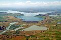
Black Butte Lake is the biggest reservoir on Stony Creek. It covers over 4,000 acres (1,600 ha) of land. Another branch, also called North Fork Stony Creek, joins the lake. Below Black Butte Dam, water from Stony Creek is sent into canals for irrigation (watering crops). The river then flows east-southeast across the Sacramento Valley. It is a wide, winding stream. North of Orland, a major town, Interstate 5 crosses the creek. Finally, Stony Creek joins the Sacramento River south of Hamilton City.
The amount of water flowing in Stony Creek changes a lot. It has the most water in winter and early spring. In summer, the creek bed is often dry because water is taken out for farming. Before dams were built, huge floods could happen every 50 years. Now, dams control the water flow.
Understanding the Stony Creek Watershed
.jpg)
The Stony Creek watershed covers 777 square miles (2,010 km2). Most of this area is in the Coast Range foothills. A smaller part is in the Sacramento Valley. The climate here has cool, wet winters and hot, dry summers. Most of the rain falls between November and April.
Black Butte Dam divides the watershed into two parts: upper and lower. Most of the upper watershed is public land, like the Mendocino National Forest. About 96 percent of the lower watershed is privately owned. The lower part of Stony Creek has formed a large alluvial fan in the Sacramento Valley. This is a fan-shaped area of rich soil built up by the river.
Underneath this area is the Stony Creek aquifer. This is a huge underground water supply. Stony Creek helps refill this aquifer. The aquifer holds a lot of water and is very important for farming.
The water quality in the upper creek can be affected by natural mercury and old mines. In the lower creek, pesticides from farms and warm temperatures can affect the water. Black Butte Lake has also had issues, like harmful algae blooms. The area between Stony Gorge and Black Butte Dams has a lot of erosion. This is due to animals grazing and the natural geology of the area.
Farming is the main activity in the area. Farmers grow almonds, olives, oranges, wheat, and corn. There are also dairy farms. In the past, logging (cutting down trees) was important in the upper watershed.
How Stony Creek Was Formed
Stony Creek flows through an area with two main types of land, called terranes. These are pieces of Earth's crust that have joined the North American continent over millions of years. To the west are the Coast Ranges. These mountains are made of old ocean rocks from the Jurassic and Cretaceous periods (about 200 to 65 million years ago).
Rocks called the Franciscan Assemblage are common in the Coast Ranges. These rocks break down easily. This is why Stony Creek carries so much sediment. Further east, closer to the Sacramento Valley, is the Stony Creek Formation. This area has rocks made of gravel, sand, and shale.
The Sacramento Valley to the east is made of layers of clay, gravel, sand, and silt. About 450,000 years ago, Stony Creek found its current path out of the mountains. The river then started building its large alluvial fan. This fan is like an inland delta, stretching from the mountains to the Sacramento River. Stony Creek has changed its path across this fan many times. The current river channel was formed about 10,000 years ago.
Plants and Animals of Stony Creek
The natural grasslands and areas along the river in the Sacramento Valley have mostly been replaced by farms. However, the foothill and mountain areas of the Stony Creek watershed have many different plant communities. The lower foothills have grasslands and oak trees. Higher up, you can find forests with live oak and black oak trees along streams. Even higher, there are Douglas fir, white fir, ponderosa pine, and sugar pine trees.
The upper part of Stony Creek is home to many fish species. These include rainbow trout, hardhead, bass, catfish, and carp. The lower creek has 28 fish species, with 13 of them being native to the area. In the past, fish like salmon and steelhead used to swim from the Pacific Ocean, up the Sacramento River, and into Stony Creek to lay their eggs.
Today, dams block fish from migrating to the upper parts of Stony Creek. Changes in how the water flows and gravel mining have also harmed the places where fish lay eggs in the lower creek.
Historically, lower Stony Creek was a wide, rocky stream with many channels, called a braided stream. Each year, floods brought new sediment to keep the riverbed wide. But when Black Butte Dam was built in 1963, it stopped 90 percent of this sediment. Now, the creek keeps eroding its banks, but no new sediment is added. This makes the creek bed narrower and deeper. This is bad for fish spawning. It also creates good conditions for invasive plants like giant reed and tamarisk.
Groups like the Glenn County Resource Conservation District are working to remove these invasive plants. The U.S. Department of Agriculture has suggested a plan to reduce sediment flowing into reservoirs. There is also a plan to dig up gravel from Black Butte Lake and put it back into the river downstream. This would help improve fish habitats.
Human History Along Stony Creek
Before Europeans arrived, about 10,000 Native Americans lived in the area. Most spoke Wintuan languages, with the Nomlaki people living near Stony Creek. Native people lived in small villages. They did not farm, but they often set fires to help certain food plants grow. In dry years, many natives moved to temporary camps along upper Stony Creek.
European settlers began arriving just before the California Gold Rush. At this time, Stony Creek was also called the Capay River. In 1843, some of the first non-natives visited the area. Later, John Bidwell explored Stony Creek to find land for settlers. In 1845, a group led by Peter Lassen found grindstones on a branch of Stony Creek. This branch is now called Grindstone Creek.
In 1846, a town called Monroeville was settled at the mouth of Stony Creek. It grew during the Gold Rush. However, it was later abandoned, and many people moved to other towns.
In 1851, Native Americans and the U.S. government tried to make a treaty for a reservation. But the treaty was never approved. Over the next few decades, diseases brought by Europeans greatly reduced the Native American population. Many children were taken from their villages and forced to work. By 1907, very few native people remained. The government then gave them a small piece of land.
_(14597482258).jpg)
The upper Stony Creek area had a lot of mining in the late 1800s and early 1900s. Mines extracted chrome ore, especially during World War II. While gold mining was not big here, small amounts of copper, mercury, and coal were also mined. The bed of Stony Creek is still an important source of gravel for construction. In 1997, over a million tons of gravel were taken from the creek each year.
More people settled in the area in the second half of the 1800s. Elk Creek started as a trading post in the 1860s. The town of Orland was founded in the 1870s when the Southern Pacific Railroad arrived. It became a center for processing grain. Hugh J. Glenn, a farmer, became known as "The Wheat King" for his large wheat farms. In 1891, Glenn County was named after him.
Farmers tried to use water from Stony Creek for irrigation starting in the 1880s. In 1906, the Orland Irrigation Project began. East Park Dam was built in 1908, and water was delivered in 1910. Stony Gorge Dam was finished in 1926. These dams helped many farmers settle in the area.
Dams on Stony Creek

The dams on Stony Creek are some of the oldest in California. They were built for farming and to control floods. East Park Dam is on Little Stony Creek. It can hold 52,000 acre-feet (64,000,000 m3) of water. This dam is listed on the National Register of Historic Places. The Rainbow Diversion Dam on Stony Creek sends water to East Park Reservoir.
Stony Gorge Dam is on the main Stony Creek. It can hold 50,000 acre-feet (62,000,000 m3) of water. Both East Park and Stony Gorge Dams are mainly used to store water for irrigation. They also help with flood control.
The Black Butte Dam was built in 1963 by the U.S. Army Corps of Engineers. It is the main dam for flood control on lower Stony Creek. Black Butte Dam can also store extra irrigation water in wet years. It originally held 160,000 acre-feet (200,000,000 m3) of water. However, sediment has filled up some of the lake, reducing its capacity.
Downstream from Black Butte Dam, the Northside diversion dam sends water into canals. These canals help water about 20,000 acres (8,100 ha) of farmland.
Images for kids
-
Stony Gorge Dam on Stony Creek, near Elk Creek
-
Map of the Stony Creek drainage basin
-
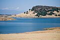
Black Butte Lake is the largest impoundment of Stony Creek and is the boundary between the upper and lower parts of the watershed.
-
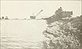
Gravel mining in the Stony Creek bed, ca. 1917
-
Aerial view of Black Butte Dam and Lake
