
Colusa County, California facts for kids
Quick facts for kids
Colusa County, California
|
||
|---|---|---|
| County of Colusa | ||

Colusa County Courthouse
|
||
|
||

Location in the state of California
|
||
| Country | United States | |
| State | California | |
| Region | Sacramento Valley | |
| Incorporated | February 18, 1850 | |
| Named for | Rancho Colus | |
| County seat | Colusa | |
| Largest city | Colusa (population) Williams (area) |
|
| Government | ||
| • Type | Council–CAO | |
| Area | ||
| • Total | 1,156 sq mi (2,990 km2) | |
| • Land | 1,151 sq mi (2,980 km2) | |
| • Water | 5.6 sq mi (15 km2) | |
| Highest elevation | 7,059 ft (2,152 m) | |
| Population
(2020)
|
||
| • Total | 21,839 | |
| • Density | 18.892/sq mi (7.294/km2) | |
| GDP | ||
| • Total | $1.781 billion (2022) | |
| Time zone | UTC-8 (Pacific Time Zone) | |
| • Summer (DST) | UTC-7 (Pacific Daylight Time) | |
| Area code | 530 | |
| Congressional district | 1st | |

Colusa County (![]() i/kəˈluːsə/) is a county in the state of California. A county is like a smaller region within a state. In 2020, about 21,839 people lived here. The main town, or county seat, is Colusa. The county is in the northern part of the Sacramento Valley, which is northwest of Sacramento, the state capital.
i/kəˈluːsə/) is a county in the state of California. A county is like a smaller region within a state. In 2020, about 21,839 people lived here. The main town, or county seat, is Colusa. The county is in the northern part of the Sacramento Valley, which is northwest of Sacramento, the state capital.
Contents
History of Colusa County
Colusa County was one of the first counties in California. It was created in 1850 when California became a state. Later, some parts of the county were given to Tehama County in 1856 and Glenn County in 1891.
The county got its name from a large piece of land called Rancho Colus. This land was given to John Bidwell in 1844 by the Mexican government. The name "Colusa" comes from "Ko'-roo" or "Korusi." This was the name of a village belonging to the Patwin people. Their village was located where the city of Colusa is today.
Early People of Colusa County
Long ago, the land that is now Colusa County was home to the Patwin people. They were a group of the Wintun people. Their territory stretched along the Sacramento River and west towards Lake County. It went north to Stony Creek and south to Putah Creek.
The Patwin people in the Colusa area spoke two different dialects. "River Patwin" was spoken by those living in villages along the Sacramento River, like Korusi. "Hill Patwin" was spoken by people living in the plains and hills to the west.
European Settlers Arrive
When Europeans settled here, parts of Colusa County were given out as Mexican land grants. These were large areas of land given by the Mexican government. John Bidwell received the Rancho Colus grant in 1845. The larger Rancho Jimeno grant surrounded it. Another grant, Larkin's Children grant, was located further up the river.
Geography of Colusa County
Colusa County covers about 1,156 square miles. Most of this area, about 1,151 square miles, is land. Only a small part, about 5.6 square miles, is water. Many streams flow through the county. These include Elk Creek, Salt Creek, Stony Creek, and Bear Creek.
The Sacramento River forms part of the county's eastern border.
Neighboring Counties
Colusa County shares borders with several other counties:
- Glenn County to the north
- Butte County to the northeast
- Sutter County to the east
- Yolo County to the south
- Lake County to the west
Protected Natural Areas
Several national protected areas are partly located in Colusa County. These areas help protect wildlife and nature.
- Butte Sink National Wildlife Refuge (part)
- Colusa National Wildlife Refuge
- Delevan National Wildlife Refuge
- Mendocino National Forest (part)
- Sacramento National Wildlife Refuge (part)
People of Colusa County
| Historical population | |||
|---|---|---|---|
| Census | Pop. | %± | |
| 1850 | 115 | — | |
| 1860 | 2,274 | 1,877.4% | |
| 1870 | 6,165 | 171.1% | |
| 1880 | 13,118 | 112.8% | |
| 1890 | 14,640 | 11.6% | |
| 1900 | 7,364 | −49.7% | |
| 1910 | 7,732 | 5.0% | |
| 1920 | 9,290 | 20.2% | |
| 1930 | 10,258 | 10.4% | |
| 1940 | 9,788 | −4.6% | |
| 1950 | 11,651 | 19.0% | |
| 1960 | 12,075 | 3.6% | |
| 1970 | 12,430 | 2.9% | |
| 1980 | 12,791 | 2.9% | |
| 1990 | 16,275 | 27.2% | |
| 2000 | 18,804 | 15.5% | |
| 2010 | 21,419 | 13.9% | |
| 2020 | 21,839 | 2.0% | |
| 2023 (est.) | 22,037 | 2.9% | |
| U.S. Decennial Census 1790–1960 1900–1990 1990–2000 2010 2020 |
|||
In 2020, the population of Colusa County was 21,839 people. Over the years, the number of people living in the county has grown quite a bit.
In 2010, the county had 21,419 people. About 64.7% of the people were White. About 55.1% of the people identified as Hispanic or Latino. People from many different backgrounds live and work in Colusa County.
Getting Around Colusa County
Main Roads
Several important highways run through Colusa County. These roads help people travel to and from different parts of the county and beyond.
 Interstate 5
 State Route 16
 State Route 20
 State Route 45
Public Transport
Colusa County Transit offers bus services. You can take a bus from Colusa to towns like Williams, Arbuckle, Grimes, and College City. There's also some service to Maxwell.
Airports
The Colusa County Airport is a small airport near the city of Colusa. It's mainly used for general aviation, like private planes. For bigger flights, the closest major airport is Sacramento International Airport.
Communities in Colusa County
Colusa County has a few cities and several smaller communities.
Cities
Census-Designated Places (CDPs)
These are areas that are like towns but are not officially incorporated as cities.
Other Communities
- Sites is another small community in the county.
California Historical Landmarks
Colusa County is home to several important historical landmarks. These places help us remember the past.
- The Colusa County Courthouse was built in 1861.
- Letts Valley was settled in 1855 by Jack and David Lett. You can find a marker at Letts Lake Campground.
- Swift's Stone Corral was built by Granville P. Swift in 1850.
Images for kids
-
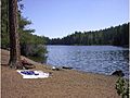
Letts Lake
-
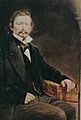
Granville Perry Swift


See also
 In Spanish: Condado de Colusa para niños
