Tehama County, California facts for kids
Quick facts for kids
Tehama County
|
||
|---|---|---|
|
||

Location in the state of California
|
||
| Country | ||
| State | ||
| Region | Shasta Cascade | |
| Incorporated | April 9, 1856 | |
| County seat | Red Bluff | |
| Largest city | Red Bluff | |
| Government | ||
| • Type | Council–Administrator | |
| Area | ||
| • Total | 2,962 sq mi (7,670 km2) | |
| • Land | 2,950 sq mi (7,600 km2) | |
| • Water | 12 sq mi (30 km2) | |
| Highest elevation | 9,239 ft (2,816 m) | |
| Population
(2020)
|
||
| • Total | 65,829 | |
| • Estimate
(2024)
|
64,451 |
|
| • Density | 22.225/sq mi (8.5809/km2) | |
| GDP | ||
| • Total | $2.517 billion (2022) | |
| Time zone | UTC-8 (Pacific Standard Time) | |
| • Summer (DST) | UTC-7 (Pacific Daylight Time) | |
| Congressional district | 1st | |
| Website | www.co.tehama.ca.us | |
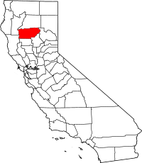
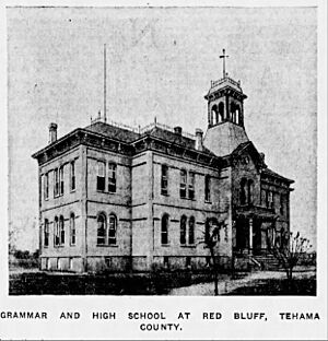
Tehama County (tə-HAY-mə) is a special area called a county in the northern part of California, a state in the United States. It's a place with beautiful nature and a rich history. In 2020, about 65,829 people lived here. The main city and where the county government is located is Red Bluff. The mighty Sacramento River flows right through the middle of the county, making it a lively place.
Contents
What Does "Tehama" Mean?
The name "Tehama" comes from the City of Tehama. Many people believe it comes from the Wintun language, meaning "high water." Other ideas suggest it could mean "low land," "salmon," "mother nature," or "shallow." Another theory, though less common, is that it comes from a Spanish word, tejamanil, which means shingle.
A Journey Through Tehama County's Past
Tehama County was officially created in 1856. It was formed from parts of three other counties: Butte, Colusa, and Shasta Counties.
Early Explorers and First Settlements
The first non-Native American settlers to make their homes here were Robert Hasty Thomes, Albert Gallatin Toomes, William George Chard, and Job Francis Dye. They received land grants from the Mexican government in 1844. Other famous early figures who explored this area included Kit Carson, Jedediah Smith, John C. Fremont, and William B. Ide, who was the first and only president of the short-lived California Republic.
Celebrating Community: Chinese Americans in Tehama County
Tehama County has a long history of diverse communities, including vibrant Chinese American communities. These communities were important parts of the county, and their members often joined in local events, blending Chinese and American traditions. This strong community spirit was shown in 1916 when many influential leaders supported the Chew family, who faced challenges at Angel Island. This act showed how much Tehama County valued its Chinese residents. This supportive environment helped a remarkable Chinese American pioneer, Dr. Kenneth Kendall Chew, to be born and grow up here. His important research in aquaculture (raising aquatic animals and plants) later made a big difference in the world.

Discovering Tehama County's Landscape
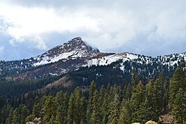
Tehama County covers a large area of about 2,962 square miles. Most of this is land (2,950 square miles), with a smaller part being water (12 square miles). Important waterways like Dye Creek, Payne's Creek, and the Sacramento River flow through the county. A small section of the beautiful Lassen Volcanic National Park is located in the northeast corner. The highest point in the county is Brokeoff Mountain, which stands tall at 9,235 feet.
Counties Nearby
Tehama County shares its borders with several other counties:
- Shasta County to the north
- Plumas County to the northeast
- Butte County to the east
- Glenn County to the south
- Mendocino County to the southwest
- Trinity County to the west
Protected Natural Areas
Parts of several important natural areas are found within Tehama County, helping to protect its wildlife and beautiful scenery:
- Lassen National Forest
- Lassen Volcanic National Park
- Mendocino National Forest
- Sacramento River National Wildlife Refuge
- Shasta–Trinity National Forest
Getting Around Tehama County
There are many ways to travel in and around Tehama County.
Main Roads and Highways
Several major highways pass through the county, connecting it to other parts of California:
 Interstate 5
 State Route 32
 State Route 36
 State Route 89
 State Route 99
 State Route 172
Public Transportation Options
The Tehama Rural Area Express (TRAX) offers local bus services in Red Bluff and connects to nearby towns like Los Molinos and Corning. You can also find Greyhound and FlixBus services that stop in Red Bluff, connecting the county to places further away. There are also plans for a commuter bus service to connect Red Bluff to the Sacramento Valley Station.
Local Airports
For air travel, Tehama County has two general aviation airports: Red Bluff Municipal Airport and Corning Municipal Airport. These airports are used for smaller planes and private flights.
Who Lives in Tehama County?
According to the 2020 census, Tehama County had a population of 65,829 people. The average age of residents was about 40.4 years old. About 24.3% of the people living here were under 18, and 20.0% were 65 or older.
The county is home to a diverse group of people. About 68.2% of residents identified as White, 2.9% as American Indian and Alaska Native, 1.6% as Asian, and 0.6% as Black or African American. Many people also identified as being from other races (14.6%) or from two or more races (11.9%). A significant portion of the population, 27.2%, identified as Hispanic or Latino.
About 43.0% of the residents lived in urban areas, which are cities and larger towns. The remaining 57.0% lived in rural areas, which are more spread out and often have farms or natural landscapes.
How Tehama County is Run
Tehama County is governed by a Board of Supervisors. These are elected officials who make decisions for the county. The county also has a Chief Administrator who helps manage daily operations.
Understanding Local Government
In national elections, Tehama County tends to vote for the Republican Party. The county is represented in the United States House of Representatives by a representative from California's 1st congressional district. In the California State Legislature, the county is part of the 1st Senate District and the 3rd Assembly District, both currently represented by Republican officials.
Cities and Towns in Tehama County
Tehama County has several cities and many smaller communities where people live.
Main Cities
Smaller Towns and Places
There are also many unincorporated communities and census-designated places (CDPs) throughout the county. These are smaller areas that might not have their own city government but are still important parts of Tehama County.
- Bend
- Dales
- El Camino
- Flournoy
- Gerber
- Kirkwood
- Lake California
- Las Flores
- Los Molinos
- Loybas Hill
- Manton
- Mill Creek
- Mineral
- Mineral CDP
- Paskenta
- Paynes Creek
- Proberta
- Rancho Tehama
- Richfield
- Vina
Communities by Size
Here's a list of the communities in Tehama County, ordered by their population size from the 2020 census:
| Rank | City/Town/etc. | Municipal type | Population (2020 Census) |
|---|---|---|---|
| 1 | † Red Bluff | City | 14,710 |
| 2 | Corning | City | 8,244 |
| 3 | Lake California | CDP | 3,377 |
| 4 | Los Molinos | CDP | 2,098 |
| 5 | Rancho Tehama | CDP | 1,572 |
| 6 | Gerber | CDP | 1,044 |
| 7 | Bend | CDP | 603 |
| 8 | Tehama | City | 435 |
| 9 | Manton | CDP | 310 |
| 10 | Richfield | CDP | 309 |
| 11 | Proberta | CDP | 237 |
| 12 | Vina | CDP | 198 |
| 13 | Las Flores | CDP | 190 |
| 14 | Mineral | CDP | 136 |
| 15 | Flournoy | CDP | 117 |
| 16 | Paskenta | CDP | 110 |
| 17 | Paynes Creek | CDP | 54 |
See Also
 In Spanish: Condado de Tehama para niños
- National Register of Historic Places listings in Tehama County, California
- Orland Buttes
- Red Bank, California
 | Aaron Henry |
 | T. R. M. Howard |
 | Jesse Jackson |


