
Mendocino County, California facts for kids
Quick facts for kids
Mendocino County, California
|
||
|---|---|---|
| County of Mendocino | ||
      Images, from top down, left to right: The community of Mendocino, the historic Grace Hudson Sun House, Point Arena Lighthouse, the Chandelier Tree, the "Skunk Train", a beach in MacKerricher State Park
|
||
|
||
| Nickname(s):
"Mendo"
|
||
| <mapframe frameless align="center" width="300" height="320" zoom="8" latitude="39.395" longitude="-123.475">[{ "type": "ExternalData", "service": "geomask", "ids": "Q108087", "properties": { "fill-opacity":0.4,"stroke":"#808080","stroke-width":2,"fill":"#808080", "title": "Mendocino County, California" } }, { "type": "Feature", "properties": { "title": "Ukiah (County seat)", "description": " ,_angle,_Route_101,_Ukiah,_California_LOC_37143730483.jpg) ", "marker-symbol": "town-hall", "marker-size": "large", "marker-color": "#FF0000" }, "geometry": { "type": "Point", "coordinates": [-123.2086, 39.1489] } }, { "type": "Feature", "properties": { "title": "Willits", "description": " ", "marker-symbol": "town-hall", "marker-size": "large", "marker-color": "#FF0000" }, "geometry": { "type": "Point", "coordinates": [-123.2086, 39.1489] } }, { "type": "Feature", "properties": { "title": "Willits", "description": " ", "marker-symbol": "town", "marker-size": "medium", "marker-color": "#FFE228" }, "geometry": { "type": "Point", "coordinates": [-123.3556, 39.4097] } }, { "type": "Feature", "properties": { "title": "Fort Bragg", "description": " ", "marker-symbol": "town", "marker-size": "medium", "marker-color": "#FFE228" }, "geometry": { "type": "Point", "coordinates": [-123.3556, 39.4097] } }, { "type": "Feature", "properties": { "title": "Fort Bragg", "description": " ", "marker-symbol": "city", "marker-size": "medium", "marker-color": "#800080" }, "geometry": { "type": "Point", "coordinates": [-123.8044, 39.4457] } }, { "type": "Feature", "properties": { "title": "Point Arena", "description": " ", "marker-symbol": "city", "marker-size": "medium", "marker-color": "#800080" }, "geometry": { "type": "Point", "coordinates": [-123.8044, 39.4457] } }, { "type": "Feature", "properties": { "title": "Point Arena", "description": " ", "marker-symbol": "village", "marker-size": "small", "marker-color": "#0000FF" }, "geometry": { "type": "Point", "coordinates": [-123.691, 38.91] } }]</mapframe> ", "marker-symbol": "village", "marker-size": "small", "marker-color": "#0000FF" }, "geometry": { "type": "Point", "coordinates": [-123.691, 38.91] } }]</mapframe>
Interactive map of Mendocino County with markers for each of its four incorporated cities: Ukiah (red), Fort Bragg (purple), Point Arena (blue), and Willits (yellow)
|
||

Mendocino County's location within California
|
||
| Country | United States | |
| State | California | |
| Region | California North Coast | |
| Incorporated | February 18, 1850 | |
| Named for | Antonio de Mendoza, Viceroy of New Spain, 1535–42 | |
| County seat | Ukiah | |
| Largest city | Ukiah | |
| Government | ||
| • Type | Council–CEO | |
| • Body | Mendocino County Board of Supervisors | |
| Area | ||
| • Total | 3,878 sq mi (10,040 km2) | |
| • Land | 3,506 sq mi (9,080 km2) | |
| • Water | 372 sq mi (960 km2) | |
| Highest elevation | 6,958 ft (2,121 m) | |
| Population
(2020)
|
||
| • Total | 91,601 | |
| • Density | 26/sq mi (10/km2) | |
| GDP | ||
| • Total | .277 billion (2022) | |
| Time zone | UTC−8 (Pacific Time Zone) | |
| • Summer (DST) | UTC−7 (Pacific Daylight Time) | |
| Area code | 707 | |
| Congressional district | 2nd | |

Mendocino County (pronounced men-duh-SEE-noh) is a county located on the North Coast of California. In 2020, about 91,601 people lived here. The main city and government center is Ukiah.
Mendocino County is special because it's located between the San Francisco Bay Area and the California/Oregon border. It's separated from the Sacramento Valley by the California Coast Ranges. This county is also part of the Pacific temperate rainforests ecoregion, which is the largest temperate rainforest area on Earth.
You can find the famous "Skunk Train" here. It used to connect Fort Bragg with Willits using a steam train. Mendocino is also one of three counties in Northern California known as the "Emerald Triangle", along with Humboldt and Trinity counties.
Contents
History of Mendocino County
.jpg)
Mendocino County was one of the first counties in California. It was created in 1850 when California became a state. At first, not many American settlers lived here. So, it was managed by Sonoma County until 1859. Some of its land was even given to Sonoma County between 1850 and 1860.
How Mendocino Got Its Name
The county's name comes from Cape Mendocino. This cape was likely named after Antonio de Mendoza. He was a important leader (Viceroy) of New Spain from 1535 to 1542. He sent an expedition to this coast in 1542. Another possible namesake is Lorenzo Suárez de Mendoza, who was a Viceroy from 1580 to 1583. The word Mendocino is a form of the family name Mendoza.
Spanish and Mexican influence didn't reach far into Mendocino County. Only two Mexican land grants were made in the southern part. These were Rancho Sanel in Hopland in 1844 and Rancho Yokaya in the Ukiah Valley in 1845.
Native American History in Mendocino
In the 1800s, many Native American tribes lived in this area. These included the Yuki, Pomo, Cahto, and Wintun tribes. Sadly, they faced many challenges. Their lands were taken, and many were forced into slavery. Attacks on their villages led to the Mendocino War in 1859, where many Native Americans lost their lives.
The Round Valley Indian Reservation was created in 1870. However, unfair treatment continued for many years. Other tribes from the Sierra Nevada mountains were also moved to this reservation. This forced march was called the "California Trail Of Tears." Many tribes who were not friendly with each other were forced to live together, which caused problems that still exist today.
Boundary Dispute with Trinity County
For a long time, there was a disagreement about the border between Mendocino and Trinity Counties. The state legislature first said the border was the 40th parallel north. A surveyor named W.H. Fauntleroy mapped this line in 1872.
Later, in 1891, a new survey found the line was actually 2 miles north of Fauntleroy's line. Both counties then claimed this 2-mile strip of land. They both tried to collect taxes from people living there. In 1907, Trinity County sued Mendocino County to solve the problem. The court decided that Fauntleroy's original survey, even if it wasn't perfectly accurate, was the official boundary. This decision was later confirmed by state law.
Geography of Mendocino County

Mendocino County covers a total area of about 3,878 square miles. Of this, 3,506 square miles are land, and 372 square miles (about 9.6%) are water.
Neighboring Counties
Mendocino County shares borders with several other counties:
- Humboldt County - to the north
- Trinity County - to the north
- Tehama County - to the northeast
- Glenn County - to the east
- Lake County - to the east
- Sonoma County - to the south
Rivers Flowing Through Mendocino

Mendocino County has many rivers, including:
- Albion River
- Big River
- Eel River
- Gualala River
- Navarro River
- Noyo River
- Russian River
- Ten Mile River
Beautiful Beaches to Explore
The county is home to many lovely beaches along its coast:
- Big River Beach
- Caspar Headlands State Beach
- Van Damme Beach
- Greenwood State Beach
- Manchester State Beach
- Navarro Beach
- Glass Beach
Protected Natural Areas
Mendocino County has many national and state parks and reserves, protecting its beautiful nature:
- Hendy Woods State Park
- MacKerricher State Park
- Mendocino National Forest
- Montgomery Woods State Reserve
- Navarro River Redwoods State Park
- Russian Gulch State Park
- Sinkyone Wilderness State Park
- Van Damme State Park
Population and People
| Historical population | |||
|---|---|---|---|
| Census | Pop. | %± | |
| 1850 | 55 | — | |
| 1860 | 3,967 | 7,112.7% | |
| 1870 | 7,545 | 90.2% | |
| 1880 | 12,800 | 69.6% | |
| 1890 | 17,612 | 37.6% | |
| 1900 | 20,465 | 16.2% | |
| 1910 | 23,929 | 16.9% | |
| 1920 | 24,116 | 0.8% | |
| 1930 | 23,505 | −2.5% | |
| 1940 | 27,864 | 18.5% | |
| 1950 | 40,854 | 46.6% | |
| 1960 | 51,059 | 25.0% | |
| 1970 | 51,101 | 0.1% | |
| 1980 | 66,738 | 30.6% | |
| 1990 | 80,345 | 20.4% | |
| 2000 | 86,265 | 7.4% | |
| 2010 | 87,841 | 1.8% | |
| 2020 | 91,601 | 4.3% | |
| 2023 (est.) | 89,108 | 1.4% | |
| U.S. Decennial Census 1790–1960 1900–1990 1990–2000 2010 2020 |
|||
In 2020, Mendocino County had a population of 91,601 people. Most residents were White (61.36%). About 26.13% of the population identified as Hispanic or Latino. The county is also home to a significant Native American population, making up 3.85%.
In 2000, the average household had 2.53 people, and the average family had 3.04 people. About 25.5% of the population was under 18 years old. The median age was 39 years.
Education in Mendocino County
Mendocino County offers various educational opportunities.
Colleges and Universities
- Mendocino College: This community college has its main campus in Ukiah. It also has centers in Willits and Fort Bragg.
- Dharma Realm Buddhist University: This is a university located in the county.
Schools for Kids (K-12)
Many school districts serve the students of Mendocino County. These include:
- Anderson Valley Unified School District
- Fort Bragg Unified School District
- Ukiah Unified School District
- Willits Unified School District
- Point Arena Joint Union High School District
Transportation and Travel

Getting around Mendocino County and connecting to other areas is possible through several ways.
Main Roads
Major highways that run through Mendocino County include:
 State Route 1
 U.S. Route 101
 State Route 20
 State Route 128
Buses and Trains
The Mendocino Transit Authority provides bus services within the county. You can also connect to buses in Sonoma County. Greyhound Bus Lines serves Ukiah. Amtrak Thruway also has connecting bus services to Ukiah, Willits, and Laytonville.
The historic Skunk Train is a special train that used to connect Fort Bragg with Willits. It's a fun way to see the area.
Airports
Mendocino County has several general aviation airports for smaller planes:
- Ukiah Municipal Airport
- Little River Airport
- Willits Municipal Airport
- Round Valley Airport
- Boonville Airport (California)
- Ocean Ridge Airport
For bigger commercial flights, people usually travel to airports in nearby counties like Eureka (Humboldt County) or Sonoma County Airport in Santa Rosa.
Communities in Mendocino County


Mendocino County has several cities, towns, and other communities.
Cities in Mendocino County
- Fort Bragg
- Point Arena
- Ukiah (This is the county seat, where the main government offices are.)
- Willits
Census-Designated Places (CDPs)
CDPs are areas that look like towns but are not officially incorporated as cities. Some of them include:
Indian Reservations
Mendocino County is home to nine Indian reservations. This is one of the highest numbers of reservations in any county in the United States. These include:
- Coyote Valley Reservation
- Hopland Rancheria
- Laytonville Rancheria
- Round Valley Reservation (partly in Trinity County)
- Sherwood Valley Rancheria
Images for kids
-
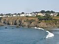
The community of Mendocino
-
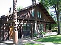
The historic Grace Hudson Sun House
-
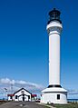
Point Arena Lighthouse
-
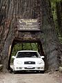
The Chandelier Tree
-
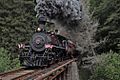
The "Skunk Train"
-
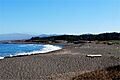
A beach in MacKerricher State Park
-
Seal of Mendocino County
-
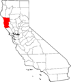
Mendocino County's location within California
-
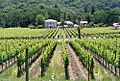
A vineyard in Mendocino County
-
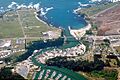
Aerial view of the mouth of the Noyo River on the Pacific Ocean at Fort Bragg
-
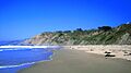
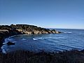
A beach near Elk
-
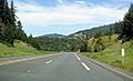
U.S. Route 101 in Mendocino County
-
Ecological staircase trail in Jug Handle State Nature Reserve
-
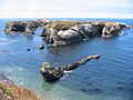
Islands off the Mendocino coast
-
Mendocino Grove

See also
 In Spanish: Condado de Mendocino para niños
