Noyo River facts for kids
Quick facts for kids Noyo River |
|
|---|---|

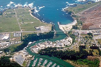
Aerial view of the mouth of the Noyo River at Fort Bragg
|
|
| Country | United States |
| State | California |
| Region | Mendocino County |
| Physical characteristics | |
| Main source | Mendocino Range 3 mi (5 km) west of Willits, California 1,560 ft (480 m) 39°24′17″N 123°25′20″W / 39.40472°N 123.42222°W |
| River mouth | Pacific Ocean Fort Bragg, California 0 ft (0 m) 39°25′40″N 123°48′33″W / 39.42778°N 123.80917°W |
| Length | 30 mi (48 km) |
| Basin features | |
| Basin size | 113 sq mi (290 km2) |
The Noyo River is a river located on the northern coast of California. It flows through Mendocino County. The river starts in the steep Mendocino Range mountains. As it flows downstream, it moves through flatter areas. Finally, it empties into the Pacific Ocean.
The area of land that drains into the Noyo River is called its watershed. This watershed covers about 113 square miles (290 km2). It reaches east towards the city of Willits. The river's end, or mouth, is at Noyo Harbor in Fort Bragg. Fort Bragg uses the Noyo River for its drinking water. The Noyo River is surrounded by other rivers. To the south is the Big River. To the east is the South Fork Eel River. To the north is the Ten Mile River. The Ten Mile River got its name because it is about ten miles from the Noyo River. The Noyo River area gets a lot of rain, usually between 40 inches (1,000 mm) and 65 inches (1,700 mm) each year.
Contents
What's in a Name?
The Pomo people are Native Americans who lived in this area. They called the Noyo River "tee'mli-bida" or "Chemli-bida." The name "Noyo" actually referred to a different village. This village was several miles north, on a creek called Pudding Creek. Over time, European settlers started using the name "Noyo" for the larger river to the south.
The name "Pudding Creek" might have come from sailors. They used to call it "put-in creek." This was because the mouth of the Noyo River was a very safe place for ships to enter. In 1855, the names of the two creeks were officially switched in a Coast Survey report.
Forests and the River
People have been cutting down trees for timber in the Noyo River watershed since the 1800s. Early logging methods, like cutting down all the trees in an area (clear-cutting), caused a lot of erosion. Erosion means that soil and rocks wash away. This led to too much sediment (dirt and small rocks) building up in the river. Also, large pieces of wood that helped trap sediment were removed from the riverbed. This was done to make the water flow better.
The Noyo River estuary, which is where the river meets the ocean, is protected by the California Bays and Estuaries Policy. In 1998, the State of California said the river had too much sediment. The watershed is slowly getting better. However, it still has a long way to go to fully recover.
Today, growing and cutting timber is still the main way land is used here. About half of the land is owned by Mendocino Redwood Company and Hawthorne Timber Company. They bought their land in 1999. The Jackson Demonstration State Forest is owned by the California Department of Forestry and Fire Protection. It makes up about one-fifth of the watershed. The rest of the land is divided into smaller pieces. These include ranches and private homes. Most of the public land is found in the state forest.
Animals of the Noyo River
The Noyo River is important for many reasons. It is used for boating and fun activities. It also provides drinking water for Fort Bragg. The river helps refill underground water sources. Most importantly, it is a home for many animals. This includes a cold, fresh water habitat for fish to travel and lay their eggs.
Fish Life Cycle
Three types of fish that live in both fresh and salt water call the Noyo River home. These are steelhead (Oncorhynchus mykiss irideus), coho salmon (Oncorhynchus kisutch), and chinook salmon (Oncorhynchus tshawytscha). These fish are very special. They are all listed under the Endangered Species Act. This means they are either "threatened" (like steelhead and chinook) or "endangered" (like coho). Other fish in the river include the three-spined stickleback, Pacific lamprey, and sculpin.
Birds and Mammals
Some birds are also very important here. These include the marbled murrelet and the northern spotted owl. These birds live closely with old, tall redwood forests. Sadly, many of these forests have been cut down since the late 1800s.
Many different mammals are thought to live in the Noyo River watershed. These include beavers, black bears, ring-tailed cats, martens, fishers, weasels, badgers, skunks, mountain lions, bobcats, seals, and sea lions. You might also see mule deer and elk. However, recent studies have not found any fishers or martens in the area.
Crossing the River
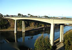
Many bridges cross the Noyo River. The most well-known is the Noyo River Bridge. It is located at Noyo Cove. This bridge carries State Route 1 and Main Street in Fort Bragg. It is a long concrete bridge, about 875-foot (267 m) long. It was built in 2005.
Other bridges include:
- One on the Georgia-Pacific Haul Road, also called the "A&W Logging Road."
- Several smaller wooden bridges on forest roads.
- A metal culvert on Forest Road 350.
- A wooden suspension bridge at Camp Noyo. This is a Boy Scout camp.
The California Western Railroad also has at least 20 crossings over the river. The current Noyo River Bridge opened in 2005. It replaced an older steel bridge built in 1948. The new bridge was designed so people could enjoy the scenic views from it.
 | Jackie Robinson |
 | Jack Johnson |
 | Althea Gibson |
 | Arthur Ashe |
 | Muhammad Ali |


