South Fork Eel River facts for kids
Quick facts for kids South Fork Eel River |
|
|---|---|

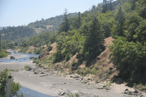
Meander in the South Fork Eel River
|
|

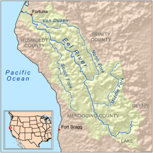
Map of the Eel River drainage basin showing the South Fork
|
|
| Country | United States |
| State | California |
| Physical characteristics | |
| Main source | Laytonville, California 2,500 ft (760 m) 39°36′46″N 123°29′34″W / 39.61278°N 123.49278°W |
| River mouth | Eel River Dyerville/Founders' Grove, California 100 ft (30 m) 40°21′21″N 123°55′10″W / 40.35583°N 123.91944°W |
| Length | 105 mi (169 km) |
| Basin features | |
| Basin size | 689 sq mi (1,780 km2) |
| Tributaries |
|
The South Fork Eel River is the biggest tributary (a smaller river that flows into a larger one) of the Eel River in northern California. It flows about 105 miles (169 km) north from Laytonville to Dyerville. There, it joins the main Eel River.
This river drains a long, narrow area of the Coast Range mountains. This area is in Mendocino and Humboldt counties. A major road, U.S. Route 101, follows the river for most of its journey.
Long ago, the Kai Pomo Indians lived in the upper part of this river's area. They were part of the Pomo Indians group. Before big industries started in the 1800s, many native tribes depended on the river. It had lots of salmon and steelhead fish. Later, in the 1920s, a company built the Benbow Dam. This dam blocked fish from swimming upstream to lay their eggs.
Today, a part of the South Fork is special. It's called a National Wild and Scenic River. This means it's protected for its natural beauty and wildlife.
Contents
River's Journey
The South Fork Eel River starts high up near Iron Mountain. This is in western Mendocino County, about 2,500 feet (760 m) above sea level. Its beginning is close to where the Ten Mile River starts.
From its high starting point, the South Fork winds north. It then turns southwest through a deep, narrow canyon. The town of Laytonville, California is only about 1 mile (1.6 km) north of where the river begins. Soon after, it gets its first important smaller stream, Section Four Creek. This creek marks the start of the protected "National Wild and Scenic River" section.
The river then flows west and northwest, passing Branscomb, California. It picks up Rock Creek and Redwood Creek. After that, it meets its first big tributary, Tenmile Creek. This creek is about 21 miles (34 km) long. It flows through a "water gap" (a valley cut through a mountain ridge) before joining the South Fork.
Flowing North
After Tenmile Creek, the South Fork generally flows north. It turns west to meet another major tributary, Rattlesnake Creek, which is about 11 miles (18 km) long. This is where the river starts to run next to U.S. Highway 101 and California State Route 271.
The river then turns northwest. It receives Big Dann Creek and another large tributary, Cedar Creek, which is about 9 miles (14 km) long. Cedar Creek also flows through a steep, wild valley. Soon after Cedar Creek, the South Fork Eel meets Hollow Tree Creek. This creek flows east, then north, then east again to join the South Fork.
The South Fork then turns west again. It flows through the Standish Hickey State Recreational Area. Then it winds north into Richardson Grove State Park. Here, the valley floor gets wider. The river receives Red Mountain Creek.
Benbow Lake and Beyond
The river reaches what used to be Benbow Lake. This lake was inside the Benbow Lake State Recreational Area near the town of Benbow, California. Benbow Lake was a seasonal lake. It was formed by a dam that was only put up in the summer.

However, since about 2009, the lake is no longer created. This is good for the river's plants and animals. The Benbow Dam was completely removed in 2016-2017. This helps fish swim freely.
At Benbow, the South Fork meets its largest tributary, the East Branch South Fork Eel River. This branch is about 20 miles (32 km) long. After the former dam site, the South Fork Eel receives another Redwood Creek. It then bends north and west around Redway, California. The river then flows through another rugged canyon. It passes the towns of Phillipsville and Miranda. West of Miranda, it receives Salmon Creek.
Final Stretch to the Eel River
The South Fork then flows north. It makes a sharp turn around a ridge, flows south, and then turns back north. Here, Highway 101 runs along one side, and California State Route 254 (Avenue of the Giants) runs along the other. Highway 101 then crosses the South Fork.
The river passes Burlington and Weott, California. Just before it joins the main Eel River, it receives its last major tributary, Bull Creek. Bull Creek is about 8 miles (13 km) long. Its entire area is inside Humboldt Redwoods State Park.
After Bull Creek, the South Fork Eel curves around Duckett Bluff. It receives its last named stream, Cabin Creek. Finally, it flows under highways and spreads out. Then it joins the Eel River.
River's Surroundings
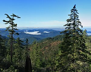
The South Fork Eel River drains a long, narrow, and mountainous area. This area covers about 689 square miles (1,780 km²). This is almost 20% of the entire Eel River area. The river's surroundings stretch from Weott in the north to Laytonville, California in the south. The highest point in this area is Iron Peak, at 4,491 feet (1,369 m). The river's mouth is much lower, at about 100 feet (30 m).
Because the area is rugged and remote, not many people live there. Even though U.S. Highway 101 and California State Route 271 follow the river for most of its length, there are few towns in its steep, forested canyon. Some towns along the river include Benbow, Garberville, Redway, and Miranda.

Many protected areas are along the river. These include Standish Hickey State Recreation Area, Richardson Grove State Park, and Humboldt Redwoods State Park. People use the river for fun activities like rafting. It also helps refill underground water supplies.
River Flow (Discharge)
The "discharge" of a river is how much water flows through it. On average, the South Fork Eel River's flow changes a lot. In its middle part, it can range from 2,000 cubic feet per second (57 m³/s) to 55 cubic feet per second (1.6 m³/s). Near its mouth, it generally ranges from 5,500 cubic feet per second (160 m³/s) to 60 cubic feet per second (1.7 m³/s).
The United States Geological Survey measures the river's flow. Near Miranda, the average flow between 1940 and 2012 was 1,833 cubic feet per second (51.9 m³/s). The highest flow ever recorded there was a massive 199,000 cubic feet per second (5,600 m³/s) on December 22, 1964. The lowest was just 10 cubic feet per second (0.28 m³/s) on August 30, 1964. This shows how much the river can change between floods and dry times.
River's Rocks and Land
The land under the South Fork Eel River is made of soft soil and rock. This rock is part of the "Franciscan Assemblage." This rock formation was created by the San Andreas Fault, a huge crack in the Earth's crust.
The steep hills and deep canyons of the South Fork Eel's area were formed by two things. First, the land is always being pushed up by the San Andreas Fault (this is called "tectonic uplift"). Second, the river and its smaller streams are constantly wearing away the land (this is called "erosion"). This creates very steep slopes.
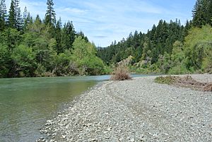
In many parts of the river, the riverbed is mostly bare gravel. The river flows in a deep channel cut into the bedrock. Flat areas called "river terraces" surround the river. These terraces are the only flat land in this very rugged area of narrow ridges and steep valleys.
River's Past
Before people from Europe settled in California, the Eel River area was home to Pomo Indians and Athapascan peoples. The Kai Pomo group lived in the very top parts of the South Fork Eel River. Their land stretched west to the main Eel River.
In 1928, the Benbow Dam was built across the South Fork near Benbow, California. This created a calm pool of water called Benbow Lake. It also led to the Benbow Lake State Recreation Area. In the rainy season, parts of the dam were removed to let water flow freely. But in the summer, the dam held back water for recreation.
The still water in the lake got very warm from the sun. This was bad for salmon and steelhead fish. These fish need cold water to survive and lay their eggs. The warm water hurt their populations. Luckily, the dam was no longer put up after 2009. The Benbow Dam was fully removed in 2016-2017. This helps the fish swim freely again.
In 2006, a special area called the South Fork Eel River Wilderness was created. It covers about 12,915 acres (5,226 ha) along parts of the river. This wilderness area is next to the King Range Wilderness. The King Range is known for having the longest undeveloped coastline in the United States outside of Alaska.
River's Wildlife
The South Fork Eel River is a very important home for many animals. It helps protect rare and endangered species. It provides cold, fresh water where fish can migrate (travel) and spawn (lay eggs).
The South Fork Eel was once full of salmon and other "anadromous" fish. Anadromous fish are those that are born in fresh water, live most of their lives in the ocean, and then return to fresh water to lay their eggs. The river was known as the best place for these fish in the area.
The main anadromous fish here are chinook salmon, coho salmon, and steelhead. It's said that the South Fork Eel River once had about half of all the coho salmon in California! In the 1930s, there were about 20,000 chinook salmon and 16,000 coho salmon.
However, the number of fish has gone down a lot. Now, there are only about 1,000 fish. This decline is mostly because of logging and road building. These activities caused a lot of "silt" (fine dirt and mud) to wash into the river. Silt fills up the deep pools where fish rest and makes the water cloudy. This harms the fish and other aquatic life. The South Fork is now one of the last places in California where wild coho salmon still live.
Some smaller streams that flow into the South Fork, like Hollow Tree Creek, also support these fish. But they have also been harmed by similar problems.
Images for kids
 | Calvin Brent |
 | Walter T. Bailey |
 | Martha Cassell Thompson |
 | Alberta Jeannette Cassell |

