
Eel River (California) facts for kids
Quick facts for kids Eel River |
|
|---|---|

The river near Dyerville, California
|
|

Map of the Eel River drainage basin
|
|
| Country | United States |
| State | California |
| County | Humboldt, Lake, Mendocino, Trinity |
| City | Fortuna |
| Physical characteristics | |
| Main source | Pacific Coast Ranges Mendocino County, California 6,245 ft (1,903 m) 39°36′51″N 122°58′12″W / 39.61417°N 122.97000°W |
| River mouth | Pacific Ocean Humboldt County, California 0 ft (0 m) 40°38′29″N 124°18′44″W / 40.64139°N 124.31222°W |
| Length | 196 mi (315 km) |
| Basin features | |
| Basin size | 3,684 sq mi (9,540 km2) |
| Tributaries |
|
| Type: | Wild, Scenic, Recreational |
| Designated: | January 19, 1981 |
The Eel River is a big river in northwestern California, about 196 miles (315 km) long. It flows through a rugged area in five counties, forming the third largest watershed (the area of land that drains into a river) entirely within California. The river generally flows north through the California Coast Ranges and empties into the Pacific Ocean near Fortuna.
The Eel River is special because its water levels change a lot. In winter, after big storms, it can be huge, but in summer, it can slow down to a trickle. It also carries a lot of sediment (like dirt and rocks) because of frequent landslides in the area. Even with these challenges, the river basin has beautiful forests, including giant redwood trees. It's also home to many salmon and steelhead trout, which are important fish.
Native American tribes lived along the Eel River for thousands of years. European explorers arrived in the 1850s. They named the river "Eel" because they traded for fish that looked like eels, but were actually Pacific lampreys. Over time, settlers came to the area, drawn by its fertile land and timber. The river became important for fishing and logging.
In the 20th century, dams were built on the Eel River to send water to other parts of California. There were also plans for much bigger dams, but these were stopped because people wanted to protect the river's natural beauty and its fish. In 1981, the Eel River was given special "Wild and Scenic River" status, which helps protect it from new dams. However, activities like logging and road-building still affect the river's environment.
Contents
Journey of the Eel River
The Eel River starts high up on Bald Mountain in Mendocino County. It flows south into Lake County and then into Lake Pillsbury, which is a reservoir created by Scott Dam. Below this dam, the river turns west and goes back into Mendocino County.
Water Diversion at Cape Horn Dam
Near Willits, there's a smaller dam called Cape Horn Dam. Here, some of the Eel River's water is sent through a tunnel to the Russian River. This project, called the Potter Valley Project, helps provide water to nearby counties.
Meeting Other Rivers
After the dam, the Eel River flows north through a quiet valley. It meets Outlet Creek and then the Middle Fork Eel River. Further downstream, the North Fork Eel River joins it. The river then briefly enters Trinity County before flowing into Humboldt County.
Lower Eel River and the Ocean
In Humboldt County, the river flows northwest past small towns. The South Fork Eel River joins it near Humboldt Redwoods State Park. Below the South Fork, the Eel River widens into a farming valley, passing towns like Scotia and Rio Dell. The Van Duzen River then flows into it. Finally, at Fortuna, the Eel River turns west and enters the Pacific Ocean through a large estuary (where the river meets the sea).
Transportation Along the River
The Northwestern Pacific Railroad tracks used to follow the Eel River for a long stretch, but they are no longer in use due to flood damage. U.S. Route 101 (also known as the Redwood Highway) runs along parts of the South Fork Eel River and the lower Eel River.
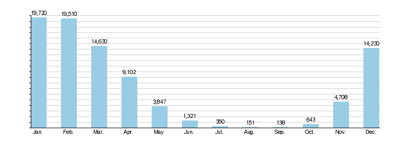
How Much Water Flows?
The amount of water in the Eel River changes a lot throughout the year. This is because of its location, which gets hit by big winter storms. In the dry summer and early fall, there's very little rain, so the river can become very small. But in January and February, the average flow can be over 100 times greater!
Record Flows
The Eel River holds a record for California. On December 23, 1964, it had the largest peak flow ever recorded for a California river. This was due to a massive storm. In contrast, during the driest months, the river can almost stop flowing.
Impact of Water Diversions
The Potter Valley Project diverts some water from the Eel River to the Russian River. While this is only a small part of the Eel River's total yearly flow (about 3%), it has a bigger impact during the dry summer months when the river's natural flow is already low. Since 2004, the dams have been managed to release more water into the Eel River during the dry season to help fish.
Eel River monthly mean discharge at Scotia (cfs)
Eel River's Home Area

The Eel River's watershed (the land area that drains into the river) covers about 3,684 square miles (9,540 km2). This makes it the third largest watershed entirely within California. The river system touches five California counties: Glenn, Humboldt, Lake, Mendocino, and Trinity. Most of the watershed is in Mendocino and Humboldt Counties.
Main Branches of the River
The Eel River has several important branches, called tributaries. These include the North Fork, Middle Fork, South Fork, and Van Duzen Rivers. The Middle Fork drains the largest area, but the South Fork carries the most water because it gets more rain.
Landscape and Land Use
The Eel River watershed is located in the California Coast Ranges, which are mountains. The land generally slopes from southeast to northwest. The only flat areas are along the larger river valleys and near the river's mouth.
Since the 1800s, activities like logging have changed the soil and water flow in the watershed. This has sometimes led to more intense floods and droughts. Today, most of the watershed is covered by forests (65.1%), shrubland (12.2%), and grassland (19.2%). Only a small part is used for farming or cities. About 32,000 people live in the watershed.
Protected Areas
A large part of the Eel River watershed is protected. This includes state parks like Humboldt Redwoods State Park and national forests like Six Rivers National Forest. A total of 398 miles (641 km) of the Eel River and its main branches are part of the National Wild and Scenic Rivers System. This special status helps keep these parts of the river wild and free from new dams.
River's Rocky Foundation

Most of the Eel River watershed sits on a type of rock called the Franciscan Assemblage. These rocks formed millions of years ago at the bottom of the Pacific Ocean. Over time, huge forces in the Earth's crust pushed these rocks up to create the Coast Ranges.
Earthquakes and Landslides
The Eel River basin is one of the most earthquake-prone areas in California. This is because three tectonic plates meet near the river's mouth. In the western and northern parts of the watershed, the soil is often sticky and unstable. This means landslides are very common, especially after heavy rains. This type of soil is sometimes called "blue goo" because of its color and how easily it slips.
Sediment in the River
The Eel River carries more sediment (dirt, sand, and rocks) per square mile than almost any other river of its size in the United States. This is due to the steep mountains, heavy rainfall, and unstable soils. Big floods can carry huge amounts of sediment downstream, changing the riverbed and affecting fish habitats.
Eel River Through Time
Early People
People have lived in the Eel River basin for thousands of years. Some of the oldest signs of human life are petroglyphs (rock carvings) found near the upper river, which might be 2,500 years old. When the first Europeans arrived, several Native American tribes lived here, including the Nongatl, Sinkyone, Lassik, and Wailaki.
European Explorers Arrive
The first European to see the Eel River was Sebastián Vizcaíno in January 1603, sailing for Spain. He sailed into the river's mouth but found no cities, only native people.
The river was officially named in 1850 during the California Gold Rush. A group of explorers led by Josiah Gregg were traveling through the area. They traded a frying pan with local fishermen for many Pacific lampreys, which they thought were eels. That's how the "Eel River" got its name!
Settlers and Industries
Many people who didn't find gold during the Gold Rush settled in the Eel River valley. They found fertile land for farming and ranching.
- Fishing: From the 1870s to the 1920s, many salmon canneries operated on the lower Eel River. However, too much fishing caused the salmon numbers to drop.
- Logging: The Eel River basin also became a major source of timber. Huge redwood logs were floated down the river. In 1884, the Eel River and Eureka Railroad started shipping lumber from the river's mouth to Humboldt Bay.
The 20th Century and Dams
In the early 1900s, two dams were built on the upper Eel River as part of the Potter Valley Project. These dams divert water to the Russian River to help provide water for people in Mendocino and Sonoma Counties. This diversion reduces the Eel River's flow, especially in summer.

In 1911, a famous engineer named John B. Leonard designed Fernbridge, a long concrete bridge over the Eel River. It's still an important crossing today. In 1914, the Northwestern Pacific Railroad completed a rail line along the river, connecting towns to the national rail network. This railroad was very expensive to build because the land was so rugged.
Plans for More Dams and Big Floods
In the 1950s and 1960s, there was interest in building much larger dams on the Eel River to supply water to Central and Southern California. One huge dam, called Dos Rios Dam, was proposed. It would have created California's largest reservoir and flooded a Native American reservation. However, many people, including California Governor Ronald Reagan, opposed these plans. They wanted to protect the river and its fish.
In 1964, a massive storm caused the "Christmas flood of 1964" on the Eel River. The river swelled to record levels, destroying towns, bridges, and homes. It also carried huge amounts of sediment and debris, which severely damaged the river's fish habitats. This flood showed how powerful the Eel River could be without major dams.
The floods also damaged the railroad along the Eel River. After another big flood in 1996-1997, the railroad was shut down for safety reasons and is unlikely to reopen along the river.
Protecting the River
After years of debate, the Eel River and its main branches were added to the National Wild and Scenic Rivers System in 1981. This means the river is now protected from new dams and large water projects, helping to preserve its natural state.
River Life

Plants of the Watershed
The Eel River watershed is known for its beautiful forests. It has many Douglas fir and western hemlock trees. It's also home to some of the largest redwood trees in California. These giant trees thrive here because the wide lower valley of the river funnels moist air from the coast far inland.
Animals of the River
Many animals live in and around the Eel River. You might spot beavers, muskrats, raccoons, river otters, and mink.
Salmon and Steelhead Trout
The Eel River is a very important home for anadromous fishes, which are fish that live in the ocean but return to fresh water to spawn (lay eggs). These include Chinook, coho salmon, steelhead (a type of rainbow trout), and coastal cutthroat trout. In the past, over a million fish would return to the river each year!
- Past Challenges: About 22,000 years ago, a huge landslide dammed the river, creating a large lake. This changed how steelhead trout spawned. Later, commercial fishing in the 1800s and early 1900s caused fish numbers to drop. Logging and grazing also loosened soil, leading to more sediment in the river, which covered or blocked fish spawning grounds. The big floods of 1955 and 1964 caused even more damage to fish habitats.
- Signs of Recovery: After the 1964 flood, Chinook salmon numbers fell very low. However, with better land management, salmon and steelhead populations have started to recover. In late 2012, over 30,000 fish returned to the river, the largest number since 1958! While numbers still go up and down, the river is showing signs of healing.
Other Fish in the Eel River
The river is home to at least 15 types of native freshwater fish. These include Pacific lampreys, Sacramento suckers, and different kinds of sculpin. The river also has some non-native fish, like the Sacramento pikeminnow, which can compete with young salmon.
It's interesting that the Eel River is named after the Pacific lamprey. These creatures look like eels but are actually a very old type of fish. Like salmon, they live in the ocean but return to the river to spawn.
Eel River Estuary
The Eel River forms a 7-mile (11 km) long estuary near Fortuna. This area, where the river meets the ocean, is very important for wildlife. It has tidal flats, wetlands, and many channels. It's the third largest coastal wetland in California and provides a vital home for shorebirds, fish, and mammals like river otters and harbor seals. Part of the estuary is protected as the Eel River Estuary Preserve.
Recreation on the Eel River
The Eel River and its branches offer many fun activities, especially whitewater kayaking and rafting.
- Kayaking and Rafting: There are exciting rapids for experienced paddlers, like a 12-mile (19 km) section between the Scott and Van Arsdale dams. A popular trip is from Dos Rios to Alderpoint, which can take several days. Further downstream, the river is calmer, perfect for flatwater boating.
- Fishing: You can find good fishing for Chinook salmon and steelhead in the lower river. Rainbow trout are found above Lake Pillsbury. Sometimes, the river is closed to fishing in the fall if there isn't enough water for salmon and steelhead to migrate.
- Camping and Hiking: The Eel River watershed is home to several state parks and national forests, including Humboldt Redwoods State Park and Mendocino National Forest. These areas are great for camping and hiking, with many swimming holes and campsites, especially above Lake Pillsbury.
Images for kids
-
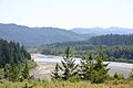
The lower Eel River in May

