North Fork Eel River facts for kids
Quick facts for kids North Fork Eel River |
|
|---|---|

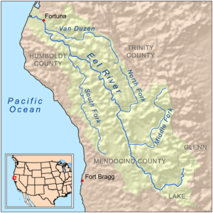
Map of the Eel River drainage basin, including the North Fork Eel River
|
|
| Country | United States |
| State | California |
| Region | Trinity County, Mendocino County |
| Physical characteristics | |
| Main source | Confluence of East and West Forks Six Rivers National Forest, Trinity County 2,123 ft (647 m) 40°12′49″N 123°23′14″W / 40.21361°N 123.38722°W |
| River mouth | Eel River About 6 miles (9.7 km) north of Spyrock, Mendocino County 574 ft (175 m) 39°57′24″N 123°26′14″W / 39.95667°N 123.43722°W |
| Length | 35.5 mi (57.1 km) |
| Basin features | |
| River system | Eel River |
| Basin size | 286 sq mi (740 km2) |
| Tributaries |
|
The North Fork Eel River is a smaller river in northwestern California. It is one of four main rivers that flow into the larger Eel River. This river runs through wild, natural areas like national forests. It drains a rugged wilderness area of about 286 square miles (740 km2).
Not many people live along its banks, which helps keep the area very clean and untouched. There are no active river gauges to measure its flow. Also, there is only one bridge (Mina Road) that crosses this river. This bridge is near the border between Trinity and Mendocino Counties.
River's Journey
The North Fork Eel River starts in southern Trinity County. It forms deep inside the Six Rivers National Forest. It begins where two smaller streams, the East Fork and West Fork, join together. The East Fork is bigger and is sometimes seen as the main part of the river.
The river flows mostly south-southeast through the North Fork Wilderness. This area is part of the national forest. Along its way, it is joined by Red Mountain Creek and Hulls Creek from the left side. After Hulls Creek joins, the river turns west and then south. It flows through a narrow valley, called a gorge, and enters Mendocino County. A few miles after crossing into Mendocino County, the river turns west again. It then flows into the main Eel River. This meeting point is about 6 miles (9.7 km) north of Spyrock.
Life in the River's Area
The land around the North Fork Eel River is called its watershed. Most human activities here are very limited. People do some farming, ranching, grazing animals, and logging. A study from 1996 found that only about 200 people live in the North Fork Eel River area full-time.
About half of the land (50%) is owned by the government. Private owners have 48% of the land. The remaining 2% belongs to the Round Valley Indian Reservation.
Many people visit the area for fun activities. These include hunting and boating. If you like rafting, the North Fork Eel River is known as a very challenging river. It can be shallow and its water level changes a lot. It has exciting rapids, which are fast-moving, rocky parts of the river. These rapids are rated as Class IV and Class III, meaning they are quite difficult. The rapids become smaller as you get closer to where the river joins the Eel River.
River's Wildlife
In the past, the North Fork Eel River was full of steelhead trout. These fish are a type of rainbow trout that live in the ocean and return to freshwater to lay eggs. There used to be two groups of steelhead trout, one that came in winter and one in spring. Experts believe there were once about 6,930 of these fish. Another type of fish, Coho salmon, might have also lived here.
However, things changed because of logging and big storms in 1964. The logging caused the soil on the hillsides to become loose. The heavy rains from the storms then made these hillsides slide into the river near its mouth. This filled the river channel with dirt, trees, and large rocks.
The strong water flows also created several waterfalls. These waterfalls made it hard for fish to swim upstream to lay their eggs. The average temperature of the river also went up. This made the river less suitable for fish to live in.
North Fork Wilderness
The North Fork Wilderness is a special protected area. It was created in 1984 and covers 8,158 acres. The U.S. Forest Service manages this wilderness area.
This wilderness includes the entire watershed of the North Fork Eel River. It is centered around a gorge, which is a deep, narrow valley. This gorge is lined with different types of conifer trees. The area is also home to many black-tailed deer.
 | William Lucy |
 | Charles Hayes |
 | Cleveland Robinson |

