
Middle Fork Eel River facts for kids
Quick facts for kids Middle Fork Eel River |
|
|---|---|

Middle Fork Eel River near Round Valley, low water, 2008
|
|

Map of the Eel River drainage basin, including the Middle Fork Eel River
|
|
| Native name | Ba-ka-wha |
| Country | United States |
| State | California |
| Region | Trinity County, Mendocino County |
| Physical characteristics | |
| Main source | Near Wrights Ridge Yolla Bolly Mountains, Trinity County 6,398 ft (1,950 m) 40°04′52″N 122°58′57″W / 40.08111°N 122.98250°W |
| River mouth | Eel River Dos Rios, Mendocino County 863 ft (263 m) 39°42′50″N 123°21′10″W / 39.71389°N 123.35278°W |
| Length | 69.8 mi (112.3 km), Northeast-southwest |
| Basin features | |
| River system | Eel River |
| Basin size | 745 sq mi (1,930 km2) |
| Tributaries |
|
The Middle Fork Eel River is a big river in northwestern California, United States. It's a main branch, or tributary, of the Eel River. This river flows through a wild and quiet area in the Yolla Bolly Mountains. These mountains are part of the California Coast Range. The river runs through Trinity and Mendocino Counties.
The area drained by the Middle Fork Eel River is called its watershed or basin. This basin covers about 745 square miles (1,930 km2) of land. That's about 20% of the entire Eel River basin! The river helps fill up underground water supplies. People also use the river for fun activities like fishing. It provides water for farms, towns, and businesses too.
Contents
Journey of the Middle Fork Eel River
The Middle Fork Eel River flows for almost 70 miles (113 kilometers). It starts high up in the Yolla Bolly-Middle Eel Wilderness. This is at the top of the Coast Range mountains. It begins where several small streams meet, a little north of Wrights Ridge.
The river first makes a big curve to the south, then to the southeast. Along the way, it meets Rattlesnake Creek. It also crosses the line between Trinity and Mendocino Counties. The river then turns south around Taliaferro Ridge. Here, Beaver Creek joins it.
Next, it flows southwest until the Black Butte River adds its waters. Williams Creek also flows into the Middle Fork. The river then continues south through the Round Valley Indian Reservation. It passes close to the town of Covelo. Mill Creek joins the river from the right.
Further on, Hayshed and Elk Creeks flow in. The river then makes a bend to the north. Finally, the Middle Fork Eel River spends its last miles flowing west. It cuts through a deep gorge. It then joins the main Eel River near Dos Rios.
Protecting the River: A Dam Proposal
In 1967, there was a big plan to build a huge dam on the Middle Fork Eel River. The U.S. Army Corps of Engineers wanted to build it near Dos Rios. This dam, called the Dos Rios Dam, would have been 730 feet (220 m) tall.
The dam would have created a very large lake. This lake would have covered 110,000 acres (450 km2) of land. This included Round Valley, which is a main farming area. It also included the town of Covelo and the Round Valley Indian Reservation. The plan was to send most of the river's water to the Central Valley for farming.
However, local people spoke out against the dam. They did not want their homes and land flooded. The governor of California at the time, Ronald Reagan, also stepped in. He helped stop the project. He said that enough agreements with the Native American tribes had already been broken.
Wildlife and Fish in the River
The Middle Fork Eel River is a very important home for many animals. It helps protect rare and endangered species. The cold, fresh water is perfect for fish to travel and lay their eggs.
In 1965, experts estimated that about 23,000 Steelhead trout (Oncorhynchus mykiss) lived in the river's 178 miles of streams. Steelhead trout are a type of fish that live in both fresh and saltwater. They swim up rivers to lay their eggs.
From 1966 to 1999, groups like the California Department of Fish and Game and the U.S. Forest Service studied the steelhead. In 1999, they called the Middle Fork's summer steelhead population "The largest remaining wild run of these magnificent fish." They also said it was likely the most important group of summer steelhead in California. This is because it had not been changed by fish hatchery programs.
However, surveys showed that the number of steelhead has gone down since 1987. In 1999, only 471 fish were counted. This shows how important it is to protect this special river and its wildlife.
Images for kids
-
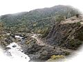
Middle Fork Eel River near Round Valley, low water, 2008
-
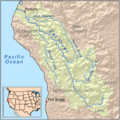
Map of the Eel River drainage basin, including the Middle Fork Eel River
