Garberville, California facts for kids
Quick facts for kids
Garberville
|
|
|---|---|

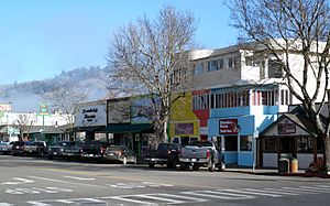
Downtown Garberville has a retail district.
|
|

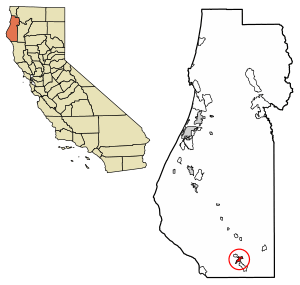
Location of Garberville in Humboldt County, California.
|
|
| Country | |
| State | |
| County | Humboldt County |
| Area | |
| • Total | 2.762 sq mi (7.154 km2) |
| • Land | 2.705 sq mi (7.006 km2) |
| • Water | 0.057 sq mi (0.148 km2) 2.1% |
| Elevation | 535 ft (163 m) |
| Population
(2010)
|
|
| • Total | 913 |
| • Density | 330.56/sq mi (127.62/km2) |
| Time zone | UTC-8 (Pacific (PST)) |
| • Summer (DST) | UTC-7 (PDT) |
| ZIP Code |
95542
|
| Area code(s) | 707 |
| GNIS feature IDs | 224036; 2611433 |
Garberville is a small community in Humboldt County, California. It's located on the South Fork of the Eel River. This town is about 52 miles (84 km) south-southeast of Eureka.
In 2010, about 913 people lived in Garberville. It is around 200 miles (322 km) north of San Francisco, California. The town is also close to Humboldt Redwoods State Park, which is known for its giant trees. Garberville is the main town in an area called the Mateel Region. This region includes parts of the Mattole and Eel River watersheds.
Contents
History of Garberville
Before written history, the Sinkyone people lived in the Garberville area.
In 1853, a Spanish explorer named Antone Garcia settled near Town Gulch. This area is now part of modern-day Garberville. The first post office in Garberville opened in 1874. Jacob C. Garber was the town's postmaster. He later named the town after himself in 1879.
Geography and Climate
Garberville is located at 40°06′01″N 123°47′42″W / 40.10028°N 123.79500°W. The town is in a small forested valley. U.S. Route 101 runs through this valley. The town sits at an elevation of 535 feet (163 meters) above sea level.
A nearby mountain, King's Peak, rises to 4,087 feet (1,246 meters).
Garberville's Climate
Garberville has a Mediterranean climate. This means it has cold, rainy winters. The summers are usually hot and dry.
| Climate data for Garberville, California | |||||||||||||
|---|---|---|---|---|---|---|---|---|---|---|---|---|---|
| Month | Jan | Feb | Mar | Apr | May | Jun | Jul | Aug | Sep | Oct | Nov | Dec | Year |
| Mean daily maximum °F (°C) | 50 (10) |
55 (13) |
60 (16) |
64 (18) |
71 (22) |
78 (26) |
86 (30) |
87 (31) |
83 (28) |
70 (21) |
56 (13) |
49 (9) |
67 (19) |
| Mean daily minimum °F (°C) | 37 (3) |
38 (3) |
39 (4) |
41 (5) |
45 (7) |
50 (10) |
53 (12) |
53 (12) |
49 (9) |
45 (7) |
41 (5) |
37 (3) |
44 (7) |
| Average precipitation inches (mm) | 13.2 (340) |
10.3 (260) |
8.9 (230) |
4.5 (110) |
1.9 (48) |
0.6 (15) |
0.1 (2.5) |
0.4 (10) |
0.9 (23) |
3.9 (99) |
9.6 (240) |
13.7 (350) |
68 (1,700) |
| Source: Weatherbase | |||||||||||||
Population and People
| Historical population | |||
|---|---|---|---|
| Census | Pop. | %± | |
| U.S. Decennial Census | |||
In 2010, the 2010 United States Census counted 913 people living in Garberville. This means there were about 330.5 people per square mile (127.6/km2).
Most of the people living in Garberville were White (89.3%). There were also smaller groups of African American (1.5%), Native American (3.2%), and Asian (1.9%) residents. About 5.9% of the population was Hispanic or Latino.
About 86% of the people lived in regular homes. The rest lived in group housing, like dorms. The average household had about 2 people.
The population included people of all ages. About 17.5% were under 18 years old. Around 13.7% were 65 years or older. The average age in Garberville was 40 years old.
Economy and Fun Things to Do
The annual Reggae on the River music festival is held near Garberville. This festival brings many visitors to the area.
Also nearby is the Benbow Inn. This historic hotel was built in 1925 and is on the National Register of Historic Places. It is known for its unique Tudor Revival style.
Education
The Southern Humboldt Unified School District was formed in 1948. It combined 19 smaller school districts. Today, it serves about 800 students. The district covers a large area of 745 square miles (1,930 km2).
The district has five elementary schools, one high school, and one learning center.
- Redway School
- Whitethorn School
- Agnes Johnson School
- Casterlin School
- Ettersburg School
- South Fork High School
- Osprey Learning Center
Infrastructure and Services
Transportation
U.S. Route 101 goes around the town. There are exits at #639 for Garberville and #642 for Redway.
The Humboldt Transit Authority provides bus service from Garberville. You can travel as far north as Trinidad by bus.
For longer trips, Amtrak Thruway Motorcoach offers public transportation.
The Garberville Airport is a public airport. It is located about 2 miles (3 km) southwest of the town.
Utilities
Garberville uses the ZIP Code 95542. The local phone area code is 707.
The Garberville Fire Protection District helps keep the community safe from fires. They have three fire engines and a utility truck.
The Garberville Water Company provides drinking water to homes. They also maintain 27 fire hydrants for emergencies. The Garberville Sanitary District manages the sewer system in the main part of the fire district.
Notable Residents
- Marshall Brant – A Major League Baseball player who was born in Garberville.
- Mike Radenbaugh – An entrepreneur known for electric bikes, who was born and grew up in Garberville.
See also
 In Spanish: Garberville para niños
 | Precious Adams |
 | Lauren Anderson |
 | Janet Collins |


