Navarro River facts for kids
Quick facts for kids Navarro River |
|
|---|---|

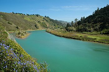
The Navarro River near its mouth.
|
|
| Native name | Spanish: Río Navarro |
| Country | United States |
| State | California |
| Region | Mendocino County |
| Physical characteristics | |
| Main source | Rancheria Creek, Mendocino County Crystal Peak 38°50′25″N 123°11′36″W / 38.84028°N 123.19333°W |
| 2nd source | Anderson Creek Sanel Mountain 38°56′45″N 123°16′10″W / 38.94583°N 123.26944°W |
| 3rd source | confluence 1 mi (2 km) south of Philo, California 39°3′12″N 123°26′25″W / 39.05333°N 123.44028°W |
| River mouth | Pacific Ocean 8 mi (13 km) south of Mendocino, California 0 ft (0 m) 39°11′32″N 123°45′40″W / 39.19222°N 123.76111°W |
| Basin features | |
| Basin size | 315 sq mi (820 km2) |
The Navarro River is a river in Mendocino County, California, United States. It is about 28.3 miles (45.5 km) long. The river flows northwest through the Coastal Range until it reaches the Pacific Ocean.
The main part of the Navarro River starts near the town of Philo. This is where two smaller streams, Rancheria Creek and Anderson Creek, join together. The river then flows to the Pacific Ocean, about 10 miles (16 km) south of the city of Mendocino.
State Route 128 follows the Navarro River valley for part of its journey. This road starts near the river's mouth and goes upstream towards Philo.
River Uses and Nature
The Navarro River is very important for local wildlife. It provides cool, fresh water where fish can travel and lay their eggs. The river is also a great place for fun activities like rafting and kayaking. You can enjoy about 26 miles (42 km) of exciting whitewater upstream from Rancheria Creek.
The river flows through two state parks. Near Philo, it passes through Hendy Woods State Park. This park is over 800 acres (320 ha) and is famous for its ancient redwood trees. Closer to the coast, the river runs through Navarro River Redwoods State Park.
The river also helps keep the underground water supply full. This water is used by farms and businesses along the western part of State Route 128. The area that drains into the river, called its watershed, covers 315 square miles (820 km2). This watershed includes the Anderson Valley, which is a well-known area for growing grapes for wine in Mendocino County.
A Look at History
Before European settlers arrived, the Navarro River was a vital water source for Native American groups in Northern California. The Pomo people, for example, depended on the river for salmon fishing and plants that grew along its banks. These resources were important for their culture and daily life.
In the mid-1800s, during the California Gold Rush, new settlers came to the valley. Sadly, this led to the forced relocation of the Pomo people. They were moved northward to the Round Valley Reservation.
Early Industries and Mills
In 1861, a sawmill was built at the mouth of the Navarro River. This mill could cut a lot of lumber each day. By 1883, it could cut 35,000 board feet (83 m3) of wood daily. To bring logs to the mill, a railroad was built that stretched 14 miles (23 km) upriver.
The first mill burned down in 1890. A new mill was built, but it also burned in 1902. Another sawmill was then built near Wendling, on the North Fork Navarro River. This mill operated until September 1927.
The Wendling sawmill had its own railway lines. These lines connected to shipping places in Albion. The train service stopped in 1930, and the railway tracks were taken apart for scrap metal in 1937.
 | Tommie Smith |
 | Simone Manuel |
 | Shani Davis |
 | Simone Biles |
 | Alice Coachman |

