
California State Route 36 facts for kids
Quick facts for kids
|
||||
|---|---|---|---|---|
| Lua error in Module:Infobox_road/map at line 15: attempt to index field 'wikibase' (a nil value).
SR 36 highlighted in red
|
||||
| Route information | ||||
| Defined by S&HC § 336 | ||||
| Maintained by Caltrans | ||||
| Length | 248.856 mi (400.495 km) | |||
| Existed | 1934–present | |||
| Tourist routes |
||||
| Major junctions | ||||
| West end | ||||
| East end | ||||
| Location | ||||
| Counties: | Humboldt, Trinity, Shasta, Tehama, Plumas, Lassen | |||
| Highway system | ||||
| State highways in California(list • pre-1964) History • Unconstructed • Deleted • Freeway • Scenic
|
||||

State Route 36 (SR 36) is a major road in California that runs from west to east. It starts near Fortuna in Humboldt County and stretches all the way to Susanville in Lassen County. This highway is about 249 miles long, which is like driving from Los Angeles to Las Vegas!
Along its path, SR 36 goes through many different types of places. It passes through the city of Red Bluff, which is the main town in Tehama County. A special part of SR 36 goes by Lassen Volcanic National Park and Lake Almanor. This section is called the Volcanic Legacy Scenic Byway, which is a nationally recognized scenic road. It's also known as a Blue Star Memorial Highway in some parts, honoring those who have served in the armed forces.
Contents
Exploring State Route 36
SR 36 begins in a small town called Alton near the coast, connecting with U.S. Route 101. From there, it heads east, winding through communities like Hydesville and Carlotta. For a while, it follows the Van Duzen River, a beautiful waterway, all the way to Bridgeville. The road then curves through Dinsmore and Cobbs, eventually entering the huge Trinity National Forest.
Journey Through Forests and Rivers
Once SR 36 enters Trinity County, it moves away from the Van Duzen River. It crosses the Mad River and passes through small towns like Mad River and Forest Glen. The road briefly turns north to meet SR 3 before heading east again. It then enters Shasta County, where it goes through Wildwood and Platina. Here, it leaves the deep forest and enters Tehama County.
In Tehama County, SR 36 passes through Rosewood before reaching the city of Red Bluff. In Red Bluff, it becomes Main Street, then Oak Street, and crosses the wide Sacramento River. It also connects with Interstate 5, a very important north-south highway. After leaving Red Bluff, it becomes Antelope Boulevard, passing by the Tehama County Fairgrounds.
Scenic Views and National Parks
East of Red Bluff, SR 36 meets California State Route 99 and turns northeast. It continues through places like Dales and Paynes Creek. Eventually, it reaches Mineral, a town located in the Lassen National Forest. Here, SR 36 joins with SR 89 for a while. These two roads together pass by Lassen Volcanic National Park, a park famous for its volcanoes and hot springs. They also meet SR 32 before entering Plumas County.
When the highway reaches the western side of Lake Almanor, a large and beautiful lake, SR 89 turns south. SR 36 continues along the northern shore of Lake Almanor, passing through the town of Chester.
Reaching the Eastern End
The route then enters Lassen County. It passes between the Lassen National Forest and Plumas National Forest, offering amazing views of nature. SR 36 also connects with SR 44 before entering the city of Susanville. In Susanville, it becomes Hillcrest Road, then Pine Street, and finally Main Street, going through the heart of the city. It meets SR 139 and CR A27 before leaving Susanville.
SR 36 officially ends when it meets U.S. Route 395 just southwest of Johnstonville. This marks the end of its long journey across northern California.
Important Road Systems
SR 36 is part of California's California Freeway and Expressway System, which means it's an important road for travel. The section east of SR 44 is also part of the National Highway System. This is a group of highways that the government considers very important for the country's economy, defense, and for people to get around easily. Even though it's not officially called a "scenic highway" by the state, many parts of SR 36, especially the section that is part of the Volcanic Legacy Scenic Byway, are incredibly beautiful to drive on.
Images for kids
-
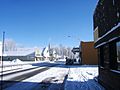
SR 36 through Chester, Plumas County

See also
 In Spanish: Ruta Estatal de California 36 para niños
