
California State Route 99 facts for kids
Quick facts for kids
|
||||
|---|---|---|---|---|
| Golden State Highway | ||||
| Lua error in Module:Infobox_road/map at line 15: attempt to index field 'wikibase' (a nil value). | ||||
| Route information | ||||
| Defined by S&HC § 399 | ||||
| Maintained by Caltrans | ||||
| Length | 424.85 mi (683.73 km)
(includes unsigned overlap with US 50 and I-5)
|
|||
| Existed | 1928 as US 99, 1964 as SR 99–present | |||
| Major junctions | ||||
| South end | ||||
| North end | ||||
| Highway system | ||||
| State highways in California(list • pre-1964) History • Unconstructed • Deleted • Freeway • Scenic
|
||||

State Route 99, often called "Highway 99," is an important road in California, United States. It is about 424.85 miles (683.73 km) long. This highway runs from the south to the north through California's Central Valley. It goes side-by-side with Interstate 5 for much of its path.
Highway 99 starts near Wheeler Ridge where it connects with Interstate 5. From there, it travels north through many major cities. These cities include Bakersfield, Fresno, Chowchilla, Modesto, Stockton, Sacramento, Chico, and Red Bluff. Most of Highway 99 is a freeway, which means cars can drive fast without stopping. However, some parts are still older, two-lane or four-lane roads that go through countryside areas.
Images for kids
-
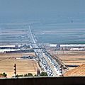
SR-99's southern terminus, and the Wheeler Ridge Interchange, viewed looking north from I-5 in the Tejon Pass.
-
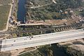
SR 99 crossing the San Joaquin River at the northern border of Fresno with the early stages of construction of California High-Speed Rail's San Joaquin River Viaduct, as well as the existing Union Pacific Railroad bridge, also visible
-
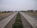
Facing north from Skyway on SR 99 in Chico with the Butte College, Chico Campus visible on the right


See also
 In Spanish: Ruta Estatal de California 99 para niños
