
Chowchilla, California facts for kids
Quick facts for kids
Chowchilla, California
|
||
|---|---|---|
_(cropped).jpg)
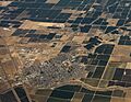
Aerial view of Chowchilla
|
||
|
||

Location in Madera County, California
|
||

Chowchilla, California
Location in the United States
|
||
| Country | ||
| State | ||
| County | Madera | |
| Incorporated | February 7, 1923 | |
| Area | ||
| • Total | 11.13 sq mi (28.83 km2) | |
| • Land | 11.09 sq mi (28.71 km2) | |
| • Water | 0.05 sq mi (0.12 km2) 0% | |
| Elevation | 240 ft (73 m) | |
| Population
(2020)
|
||
| • Total | 19,039 | |
| • Density | 1,717.39/sq mi (663.07/km2) | |
| Time zone | UTC−8 (Pacific (PST)) | |
| • Summer (DST) | UTC−7 (PDT) | |
| ZIP Code |
93610
|
|
| Area code(s) | 559 | |
| FIPS code | 06-13294 | |
| GNIS feature IDs | 277601, 2409459 | |

.jpg)
Chowchilla is a city in Madera County, California, United States. In 2020, about 19,039 people lived there. Chowchilla is located about 16 miles (26 km) northwest of Madera. It sits at an elevation of 240 feet (73 meters) above sea level.
The city is home to two large facilities: Central California Women's Facility and Valley State Prison.
Contents
History of Chowchilla
The name "Chowchilla" comes from "chaushila." This was the name of a group of Yokuts people. They were native people who lived in and around Madera County a long time ago.
Chowchilla got its first post office in 1912. The city officially became a city in 1923.
Geography and Climate
Chowchilla is located in California's Central Valley. It is about 16 miles (26 km) northwest of Madera. Madera is the main city of the county. Chowchilla is also 18 miles (29 km) southeast of Merced.
The city covers about 11.1 square miles (28.8 square kilometers) of land. Only a small part, about 0.05 square miles (0.12 square kilometers), is water. A small stream called Ash Slough flows along the northern edge of the city.
Weather in Chowchilla
Chowchilla has a Mediterranean climate. This means it has dry, hot summers. The winters are mild to cool and rainy. The city gets about 12 inches (30 cm) of rain each year. Most of the rain falls in December, January, and February. January is usually the wettest month.
During the summer, temperatures can reach 110 °F (43 °C) or even higher. There is usually no rain in summer. In winter, temperatures can drop to about 45 °F (7 °C). Fog is common from November to March. Snow is very rare in Chowchilla.
Population and People
| Historical population | |||
|---|---|---|---|
| Census | Pop. | %± | |
| 1930 | 847 | — | |
| 1940 | 1,957 | 131.1% | |
| 1950 | 3,893 | 98.9% | |
| 1960 | 4,525 | 16.2% | |
| 1970 | 4,349 | −3.9% | |
| 1980 | 5,122 | 17.8% | |
| 1990 | 5,930 | 15.8% | |
| 2000 | 11,127 | 87.6% | |
| 2010 | 18,720 | 68.2% | |
| 2020 | 19,039 | 1.7% | |
| U.S. Decennial Census | |||
The population numbers for Chowchilla include people living in the two large facilities located there.
In 2010, Chowchilla had a population of 18,720 people. About 61.6% of the people were White. About 12.6% were African American. Many people, about 37.8%, were Hispanic or Latino. The average age in Chowchilla was about 34.7 years old.
Economy
A big part of Chowchilla's economy comes from the two large facilities located in the city. These are the Central California Women's Facility and Valley State Prison. These facilities provide many jobs for people in the area.
Education
Students in Chowchilla attend public schools run by three different school districts. There is also one private school.
- Chowchilla Elementary School District serves students from kindergarten to 8th grade. It has five school campuses.
- Chowchilla Union High School District serves students from 9th to 12th grade. Students from both elementary districts go to Chowchilla Union High School.
- Alview-Dairyland Union School District serves students from kindergarten to 8th grade. This district is for students in the rural areas nearby.
The elementary schools in Chowchilla are Stephens School (Kindergarten), Fuller School (Grades 1 and 2), Ronald Reagan School (Grades 3 and 4), and Fairmead School (Grades 5 and 6). Wilson School is the middle school for grades 7 and 8.
The Alview-Dairyland Union School District has Alview Elementary School (Kindergarten to 3rd grade) and Dairyland Elementary School (4th to 8th grade).
There is also a private school called Chowchilla Seventh Day Adventist. It serves students from kindergarten to 8th grade.
Getting Around Chowchilla
Airport
The Chowchilla Airport is a local airport. It is used for smaller planes and private flights. It is located southeast of the main part of the city.
Roads
Chowchilla is located along California State Route 99 (SR 99). This major highway runs through California. Another road, California State Route 233, also serves the city.
Bus Services
Chowchilla has its own public transportation system called Chowchilla Area Transit (CATX). It is a "dial-a-ride" service. This means you call to arrange a ride, and there are no fixed bus routes. CATX operates on weekdays.
You can also connect to other cities using the Madera County Connection. This bus service connects Chowchilla to Madera, the county seat.
High-Speed Rail Plans
Chowchilla is planned to be an important spot for the future California High-Speed Rail. This is where the main train line will split. One branch will go to the San Francisco Bay Area. The other branch will continue north to Sacramento.
Famous People from Chowchilla
- Henry Farrell: A writer known for books like What Ever Happened to Baby Jane?
- Ronald D. Moore: A writer and producer for TV shows, including Star Trek and Battlestar Galactica.
- Cameron Worrell: A former professional football player for the Chicago Bears.
Images for kids
-
Aerial view of Chowchilla
-
Seal of Chowchilla
-
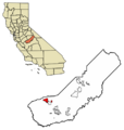
Location in Madera County, California
See also
 In Spanish: Chowchilla para niños
