
Merced, California facts for kids
Quick facts for kids
Merced
|
|||
|---|---|---|---|
| City of Merced | |||
|
|
|||
|
|||
| Country | United States | ||
| State | California | ||
| County | Merced | ||
| Incorporated | April 1, 1889 | ||
| Government | |||
| • Type | Council–manager | ||
| Area | |||
| • Total | 23.25 sq mi (60.2 km2) | ||
| • Land | 23.25 sq mi (60.2 km2) | ||
| • Water | 0.00 sq mi (0 km2) 0% | ||
| Elevation | 171 ft (52 m) | ||
| Population
(2020)
|
|||
| • Total | 86,333 | ||
| • Rank | 82nd in California | ||
| • Density | 3,712.61/sq mi (1,433.45/km2) | ||
| Time zone | UTC−8 (Pacific) | ||
| • Summer (DST) | UTC−7 (PDT) | ||
| ZIP codes |
95340–95341, 95344, 95348
|
||
| Area code | 209 | ||
| FIPS code | 06-46898 | ||
| GNIS feature IDs | 1659751, 2411080 | ||
.JPG)
.jpg)
.jpg)
.jpg)


Merced (pronounced mər-SED) is a city in California, United States. It is the main city and county seat of Merced County. The city is located in the San Joaquin Valley. Its name comes from the Merced River, which flows nearby. The word "Merced" means "Mercy" in Spanish.
Merced was officially made a city on April 1, 1889. It is a special type of city called a "charter city." This means it has its own local rules, like a mini-constitution. The city is run by a council–manager government. In this system, elected officials (the council) make decisions, and a hired manager handles the city's daily operations.
Merced is often called the "Gateway to Yosemite" because it's close to Yosemite National Park. You can drive there in less than two hours. To the west, you can reach Monterey Bay and the Pacific Ocean beaches in about the same time.
The city has good transportation links. You can travel by train with Amtrak. There's also a small airport, Merced Regional Airport, and several bus lines. Merced is about 110 miles (180 km) from Sacramento and 130 miles (210 km) from San Francisco. It's also 55 miles (89 km) from Fresno and 270 miles (430 km) from Los Angeles.
In 2005, Merced became home to the 10th University of California campus. This is the University of California, Merced (UC Merced). It was the first new research university built in the U.S. in the 21st century. As of the 2020 census, Merced had a population of 86,333 people.
Contents
History of Merced

_(cropped).jpg)
.jpg)
Merced's first post office opened in 1870. The city was officially formed in 1889. It has been governed by a council-manager system ever since.
During World War II, the Merced County fairgrounds were used as a temporary "assembly center." This is where Japanese Americans were held after being forced to leave their homes. This happened under a special order from the government. From May to September 1942, 4,669 people from central California were kept there. They were later moved to a larger camp in Colorado.
Since 2005, Merced has been home to the University of California, Merced. This university is a big part of the city's growth.
Merced has several interesting historical and cultural places. These include The Mainzer Theater, known for its history and design. There's also the County Courthouse Museum, built around 1889. Other places are the Merced Multicultural Arts Center and the County Library.
Close to the city, you can visit the Castle Air Museum and Lake Yosemite. The local newspapers are the Merced Sun-Star and the Merced County Times.
Economy and Jobs

Merced's economy has changed over time. It used to rely heavily on agribusiness (farming and related businesses). It also depended on the Castle Air Force Base. Over the last 20 years, new types of businesses have come to Merced. These include printing, making fiberglass boats, and packaging.
In 1995, the Castle Air Force Base closed down. This affected local homes and some shops. However, overall shopping in the area kept growing. More industries are now developing in Merced. The old base is now called the Castle Airport Aviation and Development Center. The Castle Air Museum is still there.
Top Employers in Merced
Many people in Merced work for these organizations:
- County of Merced
- University of California, Merced
- Merced City School District
- Merced Union High School District
- Merced College
- Quad Graphics
- City of Merced
- Scholle Corporation
- WalMart
Farming in Merced County
Merced County is one of the top farming areas in California. In 2019, the county produced $3.271 billion worth of farm products. The top five farm products in Merced County are:
- Milk
- Almonds
- Cattle
- Chickens
- Sweet Potatoes
Education in Merced

Merced offers many educational opportunities. It has a community college, Merced College, and the University of California, Merced (UC Merced).
UC Merced opened in late 2005. It is located northeast of the city. The campus covers 1,026 acres. In fall 2021, UC Merced had over 9,000 students. The most popular degrees were in Biological Sciences, Psychology, Management, and Computer Science Engineering.
The city's younger students are served by the Merced City School District. This district has five middle schools and 14 elementary schools. The Merced Union High School District has three main public high schools: Merced High School, Golden Valley High School, and El Capitan High School. There are also smaller schools for different learning needs.
Merced College is the community college. It had about 8,996 students in January 2021. Its main campus covers 267 acres.
Geography and Climate


Merced covers a total area of about 23.3 square miles (60 km2). It is located in the San Joaquin Valley.
Merced has a cold semi-arid climate. This means it has very hot and dry summers. Winters are mild and wet. On average, there are about 100 days a year when the temperature reaches 90 °F (32 °C) or higher. There are about 28 days when the temperature drops to 32 °F (0 °C) or lower.
The highest temperature ever recorded in Merced was 116 °F (47 °C) on September 6, 2022. The lowest temperature was 15 °F (−9 °C) on December 24, 1990.
The wettest year on record was 1998, with 21.98 inches (558 mm) of rain. The driest year was 2013, with only 3.79 inches (96 mm) of rain.
Transportation in Merced

Merced is connected by several major roads. These include ![]() State Route 59,
State Route 59, ![]() State Route 99, and
State Route 99, and ![]() State Route 140.
State Route 140.
Air Travel
- Merced Regional Airport offers flights to Las Vegas International Airport and Hawthorne Municipal Airport.
- Castle Airport is located nearby in Atwater, California.
Bus Services
- Several bus companies like Greyhound serve Merced.
- YARTS provides bus service directly into Yosemite National Park.
- Merced County Transit, also known as "The Bus," offers local bus routes throughout Merced County.
- CatTracks is UC Merced's own bus service. It connects students and staff to campus, apartments, and the downtown area.
Train Services
Amtrak San Joaquins provides passenger train service.

A new California High-Speed Rail system is being built. Merced will be an important stop on this new train line. The high-speed rail will connect San Francisco to the Los Angeles area. It will travel at speeds over 200 miles per hour.
Sample travel times on the high-speed rail from Merced:
- To Fresno: 30 minutes
- To Sacramento: 43 minutes
- To San Jose: 45 minutes
- To San Francisco: 1 hour and 15 minutes
- To Los Angeles: 1 hour and 40 minutes
The ACE regional train system is also planning to extend its service to Merced.
Notable People from Merced
Many well-known people have connections to Merced. These include athletes, actors, and other famous individuals.
- Lloyd Allen, MLB pitcher
- Ray Allen, NBA player
- Jeff Ball, MLB player
- Summer Bartholomew, Miss California USA 1975, Miss USA 1975
- Michael Basinger, NFL player
- Bruce Bowen, NBA player
- Jim Brewer, MLB pitcher
- Tom Cable, NFL player and coach
- Diana Serra Cary, child actress
- Alfonso Ocampo Chavez, MLS player
- Margaret Dingeldein, US Olympic water polo team member
- Tommy Duncan, singer
- Marvin Eastman, mixed martial arts fighter
- Doug Fister, MLB player
- John Flinn, MLB player
- Dylan Floro, MLB player
- Brian Fuentes, MLB player
- Katie Gallagher, reality TV finalist
- Jerry Garvin, MLB pitcher
- Jalen Green, NBA player
- Dave Henderson, MLB player
- Salar Kamangar, Former CEO of YouTube
- Philip H. Lathrop, Emmy-winning cinematographer
- Janet Leigh, actress
- Gerald Madkins, NBA player and executive
- Blas Minor, MLB pitcher
- Bill Mooneyham, MLB player
- Demi Moore, actress
- Dwayne Murphy, MLB player
- Charles Ogletree, Harvard Law School professor
- Curtis Partch, MLB player
- Mari-Lynn Poskin, politician
- Chris Pritchett, MLB player
- Peter Rojas, Founder of Engadget
- Dusty Ryan, MLB player
- Daniel Silva, novelist
- Tony Slaton, NFL player
- Steven Stayner, kidnap victim
- Rowena Granice Steele, performer and publisher
- Joyce Sumbi, librarian
- Thad Tillotson, MLB player
- Rick Williams, MLB pitcher
- Steve Sanchez, Radio Host
Images for kids
-
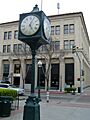
Bob Hart Square
-
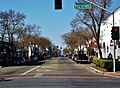
Main Street in Merced, California
-
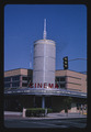
Cinema, Merced, California; photographed by John Margolies in 2003
-
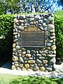
Monument commemorating the site of the Merced Assembly Center


| Climate data for Merced, California (Merced Regional Airport), 1991–2020 normals, extremes 1899–present | |||||||||||||
|---|---|---|---|---|---|---|---|---|---|---|---|---|---|
| Month | Jan | Feb | Mar | Apr | May | Jun | Jul | Aug | Sep | Oct | Nov | Dec | Year |
| Record high °F (°C) | 75 (24) |
84 (29) |
88 (31) |
98 (37) |
109 (43) |
111 (44) |
114 (46) |
114 (46) |
116 (47) |
106 (41) |
90 (32) |
76 (24) |
116 (47) |
| Mean maximum °F (°C) | 65.9 (18.8) |
71.8 (22.1) |
79.7 (26.5) |
89.4 (31.9) |
97.3 (36.3) |
103.9 (39.9) |
105.5 (40.8) |
104.9 (40.5) |
101.7 (38.7) |
92.5 (33.6) |
78.2 (25.7) |
66.1 (18.9) |
107.0 (41.7) |
| Mean daily maximum °F (°C) | 55.6 (13.1) |
62.0 (16.7) |
68.1 (20.1) |
74.0 (23.3) |
82.7 (28.2) |
90.7 (32.6) |
96.3 (35.7) |
95.1 (35.1) |
90.5 (32.5) |
79.6 (26.4) |
66.1 (18.9) |
56.0 (13.3) |
76.4 (24.7) |
| Daily mean °F (°C) | 46.3 (7.9) |
50.5 (10.3) |
55.2 (12.9) |
59.7 (15.4) |
67.4 (19.7) |
74.2 (23.4) |
79.0 (26.1) |
77.9 (25.5) |
73.5 (23.1) |
64.3 (17.9) |
53.5 (11.9) |
46.0 (7.8) |
62.3 (16.8) |
| Mean daily minimum °F (°C) | 37.0 (2.8) |
39.1 (3.9) |
42.3 (5.7) |
45.4 (7.4) |
52.1 (11.2) |
57.6 (14.2) |
61.7 (16.5) |
60.6 (15.9) |
56.5 (13.6) |
49.0 (9.4) |
40.8 (4.9) |
36.0 (2.2) |
48.2 (9.0) |
| Mean minimum °F (°C) | 27.1 (−2.7) |
29.9 (−1.2) |
33.4 (0.8) |
36.4 (2.4) |
42.8 (6.0) |
48.5 (9.2) |
54.8 (12.7) |
54.7 (12.6) |
48.4 (9.1) |
39.4 (4.1) |
31.0 (−0.6) |
26.8 (−2.9) |
25.0 (−3.9) |
| Record low °F (°C) | 16 (−9) |
20 (−7) |
20 (−7) |
25 (−4) |
30 (−1) |
37 (3) |
40 (4) |
36 (2) |
32 (0) |
28 (−2) |
21 (−6) |
15 (−9) |
15 (−9) |
| Average precipitation inches (mm) | 2.37 (60) |
2.20 (56) |
1.82 (46) |
1.12 (28) |
0.55 (14) |
0.12 (3.0) |
0.00 (0.00) |
0.00 (0.00) |
0.05 (1.3) |
0.64 (16) |
1.02 (26) |
1.91 (49) |
11.80 (300) |
| Average precipitation days (≥ 0.01 in) | 9.6 | 9.5 | 8.2 | 4.9 | 2.7 | 0.6 | 0.1 | 0.0 | 0.6 | 3.0 | 7.3 | 9.7 | 56.2 |
| Source 1: NOAA | |||||||||||||
| Source 2: National Weather Service | |||||||||||||
See also
 In Spanish: Merced (California) para niños
