
Yosemite National Park facts for kids
Quick facts for kids Yosemite National Park |
|
|---|---|
|
IUCN Category II (National Park)
|
|

Yosemite Valley from Tunnel View
|
|

Yosemite National Park
Location in California

Yosemite National Park
Location in the United States
|
|
| Location | Tuolumne, Mariposa, Mono and Madera Counties, California, United States |
| Nearest city | Mariposa, California |
| Area | 759,620 acres (3,074.1 km2) |
| Established | October 1, 1890 |
| Visitors | 3,897,070 (in 2023) |
| Governing body | National Park Service |
| UNESCO World Heritage Site | |
| Criteria | Natural: vii, viii |
| Inscription | 1984 (8th Session) |
Yosemite National Park (pronounced yoh-SEM-ih-tee) is a famous national park located in California, United States. It covers a huge area of about 759,620 acres (3,074 square kilometers). The park is known worldwide for its amazing natural beauty.
Yosemite is famous for its towering granite cliffs, powerful waterfalls, clear streams, and ancient groves of giant sequoia trees. You can also find beautiful lakes, mountains, meadows, and even small glaciers here. The park is home to many different kinds of plants and animals, making it a very special place. Almost 95% of Yosemite is protected as wilderness, meaning it's kept as natural as possible.
The park's unique landscape was formed over millions of years. About 10 million years ago, the Sierra Nevada mountains were pushed up, creating steep slopes. Then, about one million years ago, huge glaciers moved down these slopes, carving out the deep, U-shaped Yosemite Valley that we see today.
People have lived in the Yosemite area for thousands of years. Native Americans were here for nearly 4,000 years before European Americans arrived in the 1800s. Yosemite played a key role in the idea of national parks. Important figures like Galen Clark and John Muir worked hard to protect this land. Their efforts led to President Abraham Lincoln signing the Yosemite Grant in 1864, which set aside Yosemite as federally protected land. In 1890, Yosemite Valley and its surroundings officially became a National Park. Today, Yosemite attracts about four million visitors every year.
Contents
History of Yosemite
First People of Yosemite: The Ahwahneechee


The first people to live in Yosemite were the Ahwahnechee, which means "dwellers" in their language. They were the only tribe living inside what is now the park. Other related tribes, like the Southern Sierra Miwok, lived nearby. These groups often traded and married, which helped them keep their culture alive even as new settlers arrived.
The Ahwahneechee ate foods like acorns, seeds, plants, salmon, and deer. Their way of life was deeply connected to the land.
Gold Rush and Conflict
A big change came with the California Gold Rush from 1848 to 1855. Many European Americans came to California looking for gold. This led to competition for resources and land with the Native American people. The Native population dropped sharply due to diseases, less food, and conflicts.
One major conflict in Yosemite was the Mariposa War. It started in 1850 when California created a state militia to move Native people from their lands. Yosemite tribes sometimes took things from settlers and miners because they had lost their land and resources.

James Savage, a trader, led a group called the Mariposa Battalion. In 1851, they tried to move the Ahwahneechee people, led by Chief Tenaya, out of Yosemite. Many Ahwahneechee were captured and sent to a reservation, but some escaped. Chief Tenaya and others eventually fled across the Sierra Nevada mountains. Sadly, Chief Tenaya was killed in 1853.
Doctor Lafayette Bunnell, who was with the Mariposa Battalion, wrote about his amazement when he saw Yosemite Valley. He is given credit for naming Yosemite Valley, based on his talks with Chief Tenaya. Bunnell mistakenly thought "Yosemite" meant "full-grown grizzly bear."
Native People Today

After the conflicts, Native Americans continued to live in the Yosemite area, though in smaller numbers. They adapted by working in the growing tourism industry. They made and sold crafts, gave tours, and performed dances for visitors.
However, the National Park Service (NPS) later made rules that forced Native people who were not park employees to leave. In 1969, the last Native village in the park was destroyed. Today, a reconstructed "Indian Village of Ahwahnee" is located behind the Yosemite Museum.
The descendants of the Ahwahneechee and other Yosemite Natives keep their history alive. The Southern Sierra Miwuk Nation is working to gain official recognition and protect their heritage. The NPS now has policies to protect sacred sites and allow Native people to return to their homelands and use park resources.
Early Visitors and Tourism


The first tourists visited Yosemite in 1855. Among them were James Mason Hutchings, an entrepreneur, and Thomas Ayres, an artist. They helped make Yosemite famous by writing articles and creating drawings of the valley. Their efforts brought more and more visitors to the park.
Native people helped the tourism industry by working and selling handmade goods, especially woven baskets. Their presence and culture were a big attraction for early visitors.


In 1857, Galen Clark discovered the Mariposa Grove of giant sequoia trees. Simple places to stay and roads were built for visitors. The Wawona Hotel was built in 1879 to serve tourists visiting Mariposa Grove.
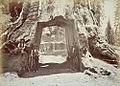
One famous tree was the Wawona Tree, a giant sequoia. In 1881, a tunnel was cut through it so carriages could drive through. This made it a popular photo spot. However, the tunnel weakened the tree, and it fell in 1969. It was about 2,100 years old.
Over time, more businesses opened in Yosemite to serve tourists. The Curry Company, started by David and Jennie Curry in 1899, founded Camp Curry, which is now Curry Village. Later, different companies merged to form the Yosemite Park & Curry Company, which built the famous Ahwahnee Hotel.
Protecting Yosemite: A National Park is Born
,_Vernal_Fall,_400_Feet,_Valley_of_Yosemite_-_Google_Art_Project.jpg)

People like Galen Clark and Senator John Conness worried about businesses harming the park. They worked to protect the area. On June 30, 1864, President Abraham Lincoln signed the Yosemite Grant. This was the first time the U.S. government set aside land specifically for preservation and public use. This decision helped pave the way for the creation of Yellowstone, the first national park, in 1872.
Yosemite Valley and the Mariposa Grove were given to California to be a state park. Galen Clark became the first guardian of the Grant.
Travel to the park improved after the first transcontinental railroad was finished in 1869. More roads were built in the 1870s, making it easier for visitors to reach Yosemite.
John Muir, a famous naturalist, played a huge role in protecting Yosemite. He wrote articles that made the area popular and helped people understand its scientific importance. Muir was one of the first to suggest that the valley's shapes were created by glaciers, which was a new idea at the time.
More Protection Efforts


Muir saw that things like too much sheep grazing and logging were damaging the giant sequoia trees. He became a strong advocate for more protection. Muir convinced important people, like Robert Underwood Johnson, editor of Century Magazine, that the area needed federal protection.
Muir and Johnson worked to get a law passed that created Yosemite National Park on October 1, 1890. However, California still controlled Yosemite Valley and Mariposa Grove. Muir's writings also helped stop sheep grazing in the park's high country.
The U.S. Army's 4th Cavalry, including the all-Black 9th Cavalry (known as the "Buffalo Soldiers"), helped manage the new national park from 1891 to 1913. They worked to improve conditions and stop problems like grazing.

Muir and his Sierra Club continued to push for a single, unified Yosemite National Park. In 1903, President Theodore Roosevelt camped with Muir near Glacier Point. Muir convinced Roosevelt to return control of Yosemite Valley and Mariposa Grove to the federal government. In 1906, Roosevelt signed a bill that made this happen.
The National Park Service Takes Over
The National Park Service (NPS) was created in 1916, and Yosemite became part of its system. More roads and campgrounds were built, and cars started entering the park in large numbers.
The Yosemite Museum was founded in 1926. It showed Native Americans practicing traditional crafts. However, the NPS's early rules sometimes limited the expression of Native culture. For example, in 1929, a park superintendent ordered the Native American village to be burned down because he thought it looked bad. In 1969, the last Native residents were forced to leave, and their village was destroyed.
In 1913, a dam was approved for Hetch Hetchy Valley in the park to provide water and power to San Francisco. Muir and the Sierra Club were against it, but the dam was built.
In 1918, Clare Marie Hodges became the first female Park Ranger in Yosemite.

By 1968, too much traffic and parking problems in Yosemite Valley became a concern. The NPS stopped some artificial attractions, like the "Firefall," where hot embers were pushed off a cliff.
In 1984, a large part of the park (about 89%) was made into the Yosemite Wilderness. This means it is kept in its natural state, with humans visiting only temporarily.
In 2016, a new area called Ackerson Meadow was added to the park. This land, which was once used for cattle ranching, is now being restored to a healthy meadow.
Geography of Yosemite
Yosemite National Park is located in the central part of the Sierra Nevada mountain range. It is next to three other wilderness areas: the Ansel Adams Wilderness, the Hoover Wilderness, and the Emigrant Wilderness.
The park is huge, covering about 1,189 square miles (3,079 square kilometers). It has thousands of lakes and ponds, 1,600 miles (2,575 km) of streams, 800 miles (1,287 km) of hiking trails, and 350 miles (563 km) of roads. Two important rivers, the Merced and the Tuolumne, start in Yosemite and flow westward.
Rocks and How They Change

Most of Yosemite's landforms are made of granite rock. About five percent of the park has older, changed volcanic and sedimentary rocks.
The valleys, canyons, and domes in Yosemite were formed by erosion working on cracks and fractures in the rock. These cracks don't move like faults. The biggest force shaping the land over millions of years has been large alpine glaciers. They changed V-shaped river valleys into U-shaped glacial canyons, like Yosemite Valley.
Exfoliation is a process where layers of rock peel off, like an onion. This happens because the granite expands when it's exposed to the surface. This process created the rounded shapes of domes like Half Dome and North Dome.
Famous Places in Yosemite

Yosemite Valley is only one percent of the park's total area, but it's where most visitors go. The Tunnel View offers an amazing view of the valley. El Capitan is a giant granite cliff that stands over the valley. It's a favorite spot for rock climbers because it's so big and has many climbing routes.
Huge granite domes like Sentinel Dome and Half Dome rise thousands of feet above the valley floor. The park has many other granite domes.
The higher parts of Yosemite have other important features like Tuolumne Meadows, the Clark Range, and the Cathedral Range. Mount Lyell is the highest point in the park, at 13,120 feet (4,000 meters).
Yosemite has three groves of ancient giant sequoia trees: the Mariposa Grove (with 200 trees), the Tuolumne Grove (25 trees), and the Merced Grove (20 trees). These trees are the largest in volume in the world and can live for a very long time.
Water and Ice in Yosemite

The Tuolumne and Merced River systems start in the park's mountains and have carved deep canyons. The park has about 3,200 lakes and 1,700 miles (2,736 km) of streams. Wetlands and meadows are common in the valley bottoms, providing important habitats.

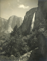
Yosemite is famous for its many waterfalls, especially in April, May, and June when the snow melts. Yosemite Falls is the fourth tallest waterfall in North America, dropping 2,425 feet (739 meters). Ribbon Falls has the highest single drop at 1,612 feet (491 meters). Bridalveil Fall is another well-known waterfall in the valley. After heavy rains or snowmelt, hundreds of temporary waterfalls appear.
The park's glaciers are small and found in shady areas. The Lyell Glacier is the largest, covering about 160 acres (0.65 square kilometers). These glaciers are not from the last Ice Age but formed more recently. Many Yosemite glaciers have disappeared, and the last two, Lyell and Maclure, are expected to vanish due to climate change.
Yosemite's Climate

Yosemite has a Mediterranean climate, which means most of its rain and snow fall during the mild winter. Summers are long, hot, and dry. The amount of rain and snow increases with elevation.
Temperatures vary greatly depending on the elevation. In the high country, temperatures can range from 25°F (-4°C) to 53°F (12°C). In Yosemite Valley, temperatures are hotter, with daily highs from 46°F (8°C) to 90°F (32°C). Even in summer, nights can be much cooler than days.
Lightning often causes fires in the dry summer months. Strong, dry winds called Mono winds can also affect the park, especially from late fall to spring.
| Climate data for Yosemite Park Headquarters, California, 1991–2020 normals, extremes 1905–present | |||||||||||||
|---|---|---|---|---|---|---|---|---|---|---|---|---|---|
| Month | Jan | Feb | Mar | Apr | May | Jun | Jul | Aug | Sep | Oct | Nov | Dec | Year |
| Record high °F (°C) | 72 (22) |
82 (28) |
90 (32) |
96 (36) |
99 (37) |
103 (39) |
112 (44) |
110 (43) |
108 (42) |
98 (37) |
86 (30) |
73 (23) |
112 (44) |
| Mean maximum °F (°C) | 58.7 (14.8) |
64.2 (17.9) |
70.4 (21.3) |
77.0 (25.0) |
83.3 (28.5) |
91.3 (32.9) |
97.4 (36.3) |
97.5 (36.4) |
93.7 (34.3) |
85.1 (29.5) |
70.9 (21.6) |
59.3 (15.2) |
99.1 (37.3) |
| Mean daily maximum °F (°C) | 47.5 (8.6) |
51.2 (10.7) |
56.7 (13.7) |
63.1 (17.3) |
70.5 (21.4) |
80.5 (26.9) |
89.2 (31.8) |
89.0 (31.7) |
83.0 (28.3) |
70.9 (21.6) |
56.0 (13.3) |
45.9 (7.7) |
67.0 (19.4) |
| Daily mean °F (°C) | 38.0 (3.3) |
40.7 (4.8) |
45.1 (7.3) |
50.4 (10.2) |
57.5 (14.2) |
65.8 (18.8) |
73.3 (22.9) |
72.9 (22.7) |
67.2 (19.6) |
56.1 (13.4) |
44.3 (6.8) |
36.8 (2.7) |
54.0 (12.2) |
| Mean daily minimum °F (°C) | 28.5 (−1.9) |
30.2 (−1.0) |
33.5 (0.8) |
37.6 (3.1) |
44.5 (6.9) |
51.0 (10.6) |
57.4 (14.1) |
56.8 (13.8) |
51.4 (10.8) |
41.3 (5.2) |
32.5 (0.3) |
27.8 (−2.3) |
41.0 (5.0) |
| Mean minimum °F (°C) | 19.2 (−7.1) |
22.0 (−5.6) |
25.2 (−3.8) |
28.4 (−2.0) |
35.2 (1.8) |
40.8 (4.9) |
49.8 (9.9) |
48.9 (9.4) |
42.0 (5.6) |
31.6 (−0.2) |
25.4 (−3.7) |
20.7 (−6.3) |
15.7 (−9.1) |
| Record low °F (°C) | −7 (−22) |
1 (−17) |
9 (−13) |
12 (−11) |
15 (−9) |
22 (−6) |
32 (0) |
32 (0) |
24 (−4) |
19 (−7) |
10 (−12) |
−1 (−18) |
−7 (−22) |
| Average precipitation inches (mm) | 6.98 (177) |
6.49 (165) |
5.47 (139) |
3.17 (81) |
1.92 (49) |
0.46 (12) |
0.29 (7.4) |
0.16 (4.1) |
0.40 (10) |
1.56 (40) |
4.05 (103) |
5.60 (142) |
36.55 (928) |
| Average snowfall inches (cm) | 16.8 (43) |
4.2 (11) |
5.2 (13) |
0.8 (2.0) |
0.0 (0.0) |
0.0 (0.0) |
0.0 (0.0) |
0.0 (0.0) |
0.0 (0.0) |
0.0 (0.0) |
3.4 (8.6) |
5.1 (13) |
35.5 (90.6) |
| Average precipitation days (≥ 0.01 in) | 8.9 | 9.0 | 11.0 | 7.2 | 6.4 | 2.2 | 1.1 | 0.9 | 2.0 | 3.5 | 5.9 | 8.5 | 66.6 |
| Average snowy days (≥ 0.1 in) | 2.5 | 1.4 | 1.5 | 0.4 | 0.0 | 0.0 | 0.0 | 0.0 | 0.0 | 0.0 | 0.5 | 1.5 | 7.8 |
| Mean daily daylight hours | 10.0 | 11.0 | 12.0 | 13.0 | 14.0 | 15.0 | 14.0 | 14.0 | 12.0 | 11.0 | 10.0 | 10.0 | 12.0 |
| Average ultraviolet index | 2 | 4 | 6 | 7 | 9 | 10 | 11 | 10 | 8 | 5 | 3 | 2 | 6 |
| Source 1: NOAA (snow/snow days 1981–2010) | |||||||||||||
| Source 2: Weather Atlas | |||||||||||||
Wildlife and Nature
Different Habitats in Yosemite

Yosemite National Park has many different vegetation zones because its elevation ranges from 2,127 feet (648 meters) to 13,114 feet (3,997 meters). These zones include:
- Chaparral and oak woodlands
- Lower mountain forests
- Upper mountain forests
- Subalpine zone (near treeline)
- Alpine (above treeline)
About half of California's 7,000 plant species can be found in the Sierra Nevada, and more than 20% of them are in Yosemite. The park has habitats for over 160 rare plants.
Yosemite protects a Sierra landscape that looks much like it did before European settlers arrived. Unlike surrounding areas that have been logged, the park has a lot of old-growth forest. These different habitats support over 250 species of animals, including fish, amphibians, reptiles, birds, and mammals.
In the western part of Yosemite, you'll find forests with ponderosa pine, sugar pine, incense cedar, and giant sequoia trees. These areas have many different kinds of wildlife, such as:
- Black bears
- Coyotes
- Raccoons
- Mountain kingsnakes
- White-headed woodpeckers
- Bobcats
- River otters
- Cougars (mountain lions)
- Spotted owls
At higher elevations, the forests change to red fir, western white pine, and lodgepole pine. Fewer animals live here because of the colder climate. Some animals you might see include:
- Golden-mantled ground squirrels
- Chickarees (small squirrels)
- Fishers (a type of weasel)
- Steller's jays
,_Yosemite_NP_-_Diliff.jpg)
Even higher up, trees become smaller and sparser, with large areas of exposed granite. Animals like the pika, yellow-bellied marmot, and Clark's nutcracker are adapted to these harsh conditions. Treeless alpine areas are home to Sierra Nevada bighorn sheep, though only a small group lives near Tioga Pass.
Meadows are important habitats at all elevations. Animals come to eat the grasses and drink from the water. Predators follow these animals. Many species prefer the edge where meadows meet forests, as it offers both open areas for food and cover for safety.
Park Management and Wildlife

Yosemite's black bears were once known for breaking into cars to find food. For many years, tourists would even watch them eat garbage at dumps. But this led to problems, so the park started a program to stop bears from getting human food. They closed dumps, installed bear-proof trash cans, and provided food lockers in campgrounds. Park staff also use special methods, like rubber bullets, to teach bears to stay away from people and their belongings. Bears that become aggressive towards people usually have to be removed from the park.
Even with its rich habitats, some animals like the California condor have disappeared from the park. Other species are now considered endangered. The biggest threats to Yosemite's wildlife include:
- Lack of natural fires (which are important for some plants)
- Exotic species (plants and animals not native to the area)
- Air pollution
- Habitat fragmentation (habitats being broken into smaller pieces)
- Climate change
Locally, things like road kills and bears getting human food also affect some animals.

More than 130 non-native plant species have been found in Yosemite. These plants were brought in by early settlers. They can spread quickly, especially after fires or construction. Some non-native plants push out native plants and change the ecosystem. For example, yellow star thistle has long roots that help it take water away from native plants.
Wildfires in Yosemite

Native Americans used to set small, controlled fires to clear brush and help their farming. These fires also helped keep the forest healthy and reduced the risk of large, uncontrolled wildfires. They helped preserve the variety of plants and animals.
Forest fires are a natural part of the ecosystem. They clear out dead plants, allowing new growth to appear. However, large fires can harm tourism and park facilities. In 2018, a large fire called the Ferguson Fire caused parts of Yosemite to close temporarily.
Things to Do in Yosemite


Yosemite National Park is open all year. However, some roads and trails close during the snowy winter months, usually from November to May or June.
During the busy summer season (June to August), traffic in Yosemite Valley can be very heavy. The park offers a free shuttle bus system in the valley to help visitors get around. Parking can be hard to find. You can also get to Yosemite by Amtrak train and the Yosemite Area Regional Transportation System (YARTS) bus from nearby towns.
The Yosemite Valley Visitor Center, the Yosemite Museum, and the Nature Center at Happy Isles offer information about the park's natural and cultural history.
Hiking Adventures
.jpg)
Yosemite has over 800 miles (1,287 km) of trails for hikers. You can find everything from easy walks to challenging mountain hikes and backpacking trips.
A very popular hike is to the top of Half Dome. This hike requires a permit when the cables are up (usually from late May to early October). Only 300 hikers are allowed past the base of the subdome each day.
The park is divided into five main areas for exploring:
- Yosemite Valley
- Wawona/Mariposa Grove/Glacier Point
- Tuolumne Meadows
- Hetch Hetchy
- Crane Flat/White Wolf
For overnight trips into the backcountry, you need a wilderness permit and special bear-resistant food storage containers.
Driving and Biking
While many places in Yosemite require hiking, some can be reached by car. The most famous road is Tioga Road.
Bicycles are allowed on roads, but there are only about 12 miles (19 km) of paved bike paths in Yosemite Valley. Mountain biking is not allowed on trails.
Rock Climbing

Rock climbing is a big part of Yosemite. The valley is surrounded by huge rock faces like Half Dome and El Capitan. Camp 4, a campground in the Valley, is famous for its role in the history of rock climbing. You can often see climbers on the rocks during the warmer months. Classes on rock climbing are also offered.
Tuolumne Meadows is also well known for rock and mountain climbing.
Winter Fun

In winter, much of the park is covered in snow, and many roads close. You can go downhill skiing at the Badger Pass Ski Area, which is California's oldest downhill skiing area. It's usually open from mid-December to early April.
Many parts of the park are open for cross-country skiing and snowshoeing. There are also backcountry ski huts for overnight trips. You need a wilderness permit for overnight ski trips.
The Bracebridge Dinner is a special holiday event held every year at the Ahwahnee Hotel since 1927. It's inspired by old English Christmas traditions.
Other Activities
Yosemite has 13 official campgrounds for visitors.
You can rent bicycles from spring through fall. Helmets are required for children under 18.
Water activities are popular in warmer months. You can go rafting on the Merced River in the valley from late May to July. Swimming pools are available at Yosemite Lodge and Curry Village.
Horsetail Fall: The Firefall Effect
Horsetail Fall is a small waterfall that flows over the eastern edge of El Capitan. It usually flows only in winter and can be hard to spot. But on rare evenings in mid-to-late February, if the sky is clear, the waterfall can glow orange. This happens when the setting sun shines on it just right, making it look like a "firefall." It's a natural event that reminds people of the old human-made Firefall that used to happen from Glacier Point.
Images for kids
-

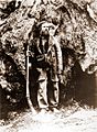
Sculpture of Chief Tenaya made by Sal Maccarone for the Tenaya Lodge in Yosemite National Park
-
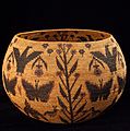
Basket woven by Lucy Telles (1885–1955), a Mono Lake Paiute and Southern Sierra Miwok Native American artist from the Yosemite region
-
The Dead Giant (c. 1870s)
-
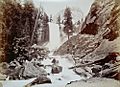
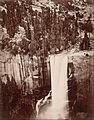
Vernal Fall (c. 1870s)
-
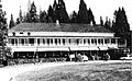
The Wawona Hotel (1985)
-
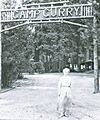
Jennie Curry in front of Camp Curry (c. 1900)
-
Eadweard Muybridge, Vernal Fall, 1872
-
Willard Worden, Yosemite Falls, c. 1910
-
Early settler, Galen Clark
-
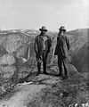
Theodore Roosevelt and John Muir on Glacier Point
-
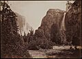
Bridalveil Fall and El Capitan, by Carleton Watkins (c. 1880)
-
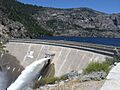
O'Shaughnessy Dam in Hetch Hetchy Valley
-
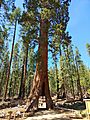
Tunnel tree at Yosemite National Park in May 2022
-
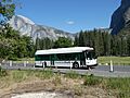
Yosemite Valley Shuttle System bus, a free bus service
-
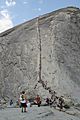
Hikers line the Half Dome cables on a busy summer day in 2008
-
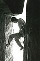
Climbing the Narrows in Sentinel Rock
-
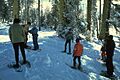
A ranger-guided snowshoe walk in the park
See also
 In Spanish: Parque nacional de Yosemite para niños
- Buffalo Soldiers (park rangers)
- List of national parks of the United States
- National parks in California
- Yosemite Sam – Warner Bros. theatrical cartoon character
