Sentinel Dome facts for kids
Quick facts for kids Sentinel Dome |
|
|---|---|

Sentinel Dome
|
|
| Highest point | |
| Elevation | 8,127 ft (2,477 m) NAVD 88 |
| Prominence | 322 ft (98 m) |
| Parent peak | Illilouette Ridge |
| Geography | |
| Location | Yosemite National Park, Mariposa County, California, U.S. |
| Parent range | Sierra Nevada |
| Topo map | USGS Half Dome |
| Geology | |
| Age of rock | Cretaceous |
| Mountain type | Granite dome |
| Climbing | |
| Easiest route | Hike up northeast slope. |
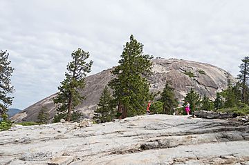
Sentinel Dome is a huge, rounded rock formation in Yosemite National Park, United States. It's like a giant, smooth hill made of granite. You can find it on the south side of Yosemite Valley. It stands about 8,127 feet (2,477 meters) tall.
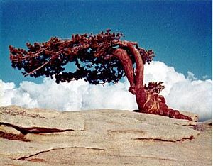
Sentinel Dome was once famous for a special Jeffrey pine tree that grew right on its top. This tree was photographed by famous artists like Carleton Watkins and Ansel Adams. Sadly, the tree died in a drought in 1976. It stayed standing for many years but finally fell in 2003.
What is Sentinel Dome?
Sentinel Dome is a type of mountain called a granite dome. This means it's a large, rounded hill made of a very hard rock called granite. It was formed a very long time ago, during the Cretaceous period.
History of Sentinel Dome
The Native American people who lived here, the Southern Sierra Miwok, called Sentinel Dome "Sakkaduch." Later, a survey team led by Lafayette Bunnell called it "South Dome." But another group, the Whitney survey, renamed it Sentinel Dome. They thought it looked like a watchtower, keeping an eye on the valley.
From the top of Sentinel Dome, you get an amazing 360-degree view! You can see many famous spots in Yosemite Valley, like Half Dome, El Capitan, and Yosemite Falls. It's also a popular place to look at the stars at night, along with nearby Glacier Point.
Hiking to Sentinel Dome
Getting to Sentinel Dome is a fun adventure! There's a hiking trail that leads to the base of the dome. It's a fairly easy hike, about 1.1 miles (1.8 kilometers) long.
The start of the trail is on the Glacier Point road. It's the same trailhead you use to get to Taft Point. Once you reach the bottom of the dome, you can walk up the less steep side to reach the very top.
In winter, when there's snow, you can even reach Sentinel Dome by skiing! It's a longer trip, about 10 miles (16 kilometers) from Badger Pass.
 | Leon Lynch |
 | Milton P. Webster |
 | Ferdinand Smith |


