
Mariposa County, California facts for kids
Quick facts for kids
Mariposa County
|
|||
|---|---|---|---|
  The Mariposa County Courthouse (top) and Yosemite Valley from Tunnel View (bottom)
|
|||
|
|||

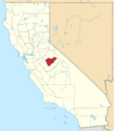
Location in the state of California
|
|||
| Country | United States | ||
| State | California | ||
| Region | Sierra Nevada | ||
| Incorporated | February 18, 1850 | ||
| Named for | Spanish word for "butterfly" and Mariposa Creek | ||
| County seat | Mariposa | ||
| Largest community | Mariposa (population) Greeley Hill (area) |
||
| Government | |||
| • Type | Council–CAO | ||
| • Body | Board of Supervisors | ||
| Area | |||
| • Total | 1,463 sq mi (3,790 km2) | ||
| • Land | 1,449 sq mi (3,750 km2) | ||
| • Water | 14 sq mi (40 km2) | ||
| Highest elevation | 12,040 ft (3,670 m) | ||
| Population
(2020)
|
|||
| • Total | 17,131 | ||
| • Density | 11.710/sq mi (4.5211/km2) | ||
| GDP | |||
| • Total | .849 billion (2022) | ||
| Time zone | UTC-8 (Pacific Standard Time) | ||
| • Summer (DST) | UTC-7 (Pacific Daylight Time) | ||
| Congressional district | 5th | ||


Mariposa County is a special place in California. It's a county located in the western part of the Sierra Nevada mountains. In 2020, about 17,131 people lived here. The main town, or county seat, is called Mariposa.
A big part of Yosemite National Park is in the eastern section of Mariposa County. This county is one of only three in California that doesn't have any official cities. Instead, it has 17 smaller communities. Fun fact: Mariposa County doesn't have any permanent traffic lights!
Contents
History of Mariposa County
Mariposa County was one of the first 27 counties created in California. This happened when California became a state in 1850. At first, it was the largest county in California. But over time, parts of Mariposa County were used to form 12 other counties. Because of this, Mariposa County is known as the "Mother of Counties."
The county's first main town was called Agua Fria, which means "cold water" in Spanish. Later, in 1854, the county seat moved to Mariposa. This led to the building of the historic Mariposa County Courthouse. You can even see the courthouse on the Mariposa County Seal!
The county got its name from Mariposa Creek. In 1806, Spanish explorers saw many butterflies ("mariposas" in Spanish) near the Sierra foothills. Every year, in early May, people celebrate the arrival of monarch butterflies with a "Butterfly Days" festival and parade.
The Gold Rush in Mariposa County

Mariposa County is at the southern end of California's Mother Lode area. This is where a lot of gold was found during the California Gold Rush. People first found gold in stream-beds. Later, they dug mines deep into the ground.
A famous explorer named John Charles Frémont became very rich from the gold here. He was even a candidate for president in 1856. The local hospital and a street (Highway 140) are named after him. Another street, Jessie Street, is named after his wife, Jessie Benton Frémont.
You can learn more about the county's mining history at two local museums:
- The Mariposa History Museum in the town of Mariposa.
- The California Mining and Mineral Museum at the Mariposa Fairgrounds.
Some small gold mines in Mariposa County still find very special and expensive gold pieces. These are often beautiful crystals of gold. One famous piece, called "The Dragon," is now on display at the Houston Museum of Natural Science.
Geography of Mariposa County
Mariposa County covers about 1,463 square miles. Most of this is land, with a small amount of water. The county stretches from the western foothills of the Sierra Nevada mountains to the edge of the Central Valley. It also goes east into the Sierra, including Yosemite Valley and part of the Cathedral Range.
Waterways and Lakes
A large part of the Merced River flows through Mariposa County. This includes its white water sections in Yosemite and the Merced River Canyon. The Merced River Canyon is the only place where the limestone salamander lives. This is a rare species found only in Mariposa County.
There are also several lakes in the county:
- Lake McClure
- Lake McSwain
- Merced Lake
- Tenaya Lake
Counties Nearby
Mariposa County shares borders with these other counties:
- Tuolumne County - to the north
- Madera County - to the southeast
- Merced County - to the southwest
- Stanislaus County - to the west
- Mono County - to the east
Protected Natural Areas
Parts of these important natural areas are in Mariposa County:
- Sierra National Forest
- Stanislaus National Forest
- Yosemite National Park
People of Mariposa County (Demographics)
In 2020, the population of Mariposa County was 17,131 people. Most people in the county are White. There are also people from many other backgrounds, including Native American, Asian, and Hispanic or Latino.
In 2014, the largest groups of people based on where their families originally came from were:
- German (14.5%)
- English (13.4%)
- Irish (12.7%)
- Italian (4.1%)
- "American" (3.8%)
- Scottish (3.2%)
- Portuguese (3.0%)
Healthcare in Mariposa County
Mariposa County has one hospital, called John C. Fremont Hospital.
Media in Mariposa County
People in Mariposa County mostly get their TV and radio from Fresno. The county also has its own local news:
- Mariposa Gazette
- Sierra Sun Times
Getting Around Mariposa County (Transportation)
Main Roads
Here are the major highways that go through Mariposa County:
 State Route 41
 State Route 49
 State Route 120
 State Route 140
Public Transport
- Mariposa County Transit offers ride services and some bus routes.
- Yosemite Area Regional Transportation System (YARTS) provides bus service to Yosemite National Park.
- Amtrak Thruway: Bus service connects Mariposa to the Merced train station and Yosemite.
Airports
The Mariposa-Yosemite Airport is a small airport for general aviation. For bigger flights, the closest airports are Fresno and Merced.
Communities in Mariposa County

Mariposa County does not have any incorporated cities. Instead, it has several communities, some of which are called "census-designated places" (CDPs) for counting purposes.
Census-Designated Places (CDPs)
Unincorporated Communities
These are other communities that are not officially recognized as CDPs:
- Foresta
- Jerseydale
- Mormon Bar
- Lushmeadows
Images for kids
-
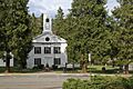
The Mariposa County Courthouse
-
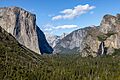
Yosemite Valley from Tunnel View
-
Flag of Mariposa County
-
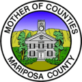
Seal of Mariposa County
-
Location of Mariposa County in California
See also
 In Spanish: Condado de Mariposa para niños
