Mount Bullion, Mariposa County, California facts for kids
Quick facts for kids
Mount Bullion
|
|
|---|---|

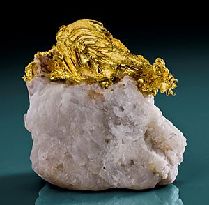
Gold on quartz, Mockingbird Mine near Mt. Bullion
|
|
| Country | United States |
| State | California |
| County | Mariposa |
| Area | |
| • Total | 0.611 sq mi (1.58 km2) |
| • Land | 0.610 sq mi (1.58 km2) |
| • Water | 0.001 sq mi (0.003 km2) |
| Elevation | 2,152 ft (656 m) |
| Population
(2020)
|
|
| • Total | 154 |
| • Density | 252.5/sq mi (97.5/km2) |
| Time zone | UTC-8 (Pacific (PST)) |
| • Summer (DST) | UTC-7 (PDT) |
| ZIP Code |
95338 (Mariposa)
|
| GNIS feature IDs | 233575; 2812657 |
Mount Bullion is a small community in Mariposa County, California, United States. It is known as an "unincorporated community." This means it's a town that doesn't have its own local government. Instead, it's managed by the county.
Mount Bullion is also a "census-designated place" (CDP). This is a special area that the government counts for population. In 2020, about 154 people lived in Mount Bullion.
The Story Behind the Name
Mount Bullion has had a few different names over time. When it was first settled, it was called "La Mineta." This name means "little mine" in Spanish. It was likely named this because of small mining operations nearby.
Later, the community was called "Princeton." This name came from a mine close by, known as the Princeton Mine. Mining for gold was very important in California's history.
Finally, the name "Mount Bullion" was chosen. This name honors a famous politician named Senator Thomas Hart Benton. He was a senator from Missouri. His nickname was "Old Bullion." He earned this nickname because of his strong ideas about money and how the government should handle it. He believed in using gold and silver coins, which were called "bullion."
A post office served the community for many years. It operated in Mount Bullion from 1862 until 1955. There was a short time in 1887 when it was closed.
Where is Mount Bullion?
Mount Bullion is located in the western part of Mariposa County. It sits along California State Route 49. This road is an important route in California.
The community is about 5 miles (8 kilometers) northwest of Mariposa. Mariposa is the main town and the county seat. This means it's where the county government offices are located. Mount Bullion is also about 6 miles (10 kilometers) southeast of Bear Valley.
The elevation of Mount Bullion is about 2,152 feet (656 meters) above sea level. This means it's located in the hills, not in a flat valley.
Land and Water
The Mount Bullion census-designated place covers a total area of about 0.61 square miles (1.58 square kilometers). Almost all of this area is land. Only a tiny part, about 0.001 square miles (0.003 square kilometers), is water.
The town is built on a low ridge. This ridge separates the beginnings of different creeks. Agua Fria Creek flows to the southeast from here. Norwegian Gulch and Green Gulch start here and flow west. Both of these creek systems eventually lead southwest into the large San Joaquin Valley.
 | Chris Smalls |
 | Fred Hampton |
 | Ralph Abernathy |


