Mariposa, California facts for kids
Quick facts for kids
Mariposa
|
|
|---|---|

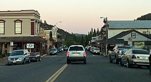
Dusk in downtown Mariposa
|
|

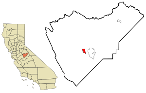
Location in Mariposa County and the state of California
|
|
| Country | |
| State | |
| County | |
| Area | |
| • Total | 4.040 sq mi (10.46 km2) |
| • Land | 4.037 sq mi (10.46 km2) |
| • Water | 0.003 sq mi (0.008 km2) 0.07% |
| Elevation | 1,949 ft (594 m) |
| Population
(2020)
|
|
| • Total | 1,526 |
| • Density | 378.0/sq mi (145.9/km2) |
| Time zone | UTC-8 (Pacific Time Zone) |
| • Summer (DST) | UTC-7 (PDT) |
| ZIP code |
95338
|
| Area code | 209 |
| FIPS code | 06-45932 |
| GNIS feature IDs | 1659063, 2408181 |
Mariposa is a small community in California, United States. Its name means "Butterfly" in Spanish. Early explorers saw many monarch butterflies here, which is how the town got its name. Mariposa is the main town, or county seat, of Mariposa County. In 2020, about 1,526 people lived there.
Contents
Exploring Mariposa's Location and Surroundings

Mariposa is located in the Sierra Nevada mountains' foothills. It sits about 1,949 feet (594 meters) above sea level. Mariposa Creek flows right through the town. The area has different types of soil. These soils help grow trees like blue oak and ponderosa pine.
Two important California roads, Highway 49 and Highway 140, meet in Mariposa. They combine for a short distance as the town's main street. Highway 140 is a direct route to Yosemite Valley, which is about 42 miles (68 km) northeast.
Mariposa County includes a big part of Yosemite National Park. Because of this, a lot of the local economy depends on tourism. Many visitors come through Mariposa on their way to the park.
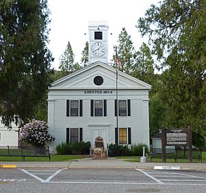
The county courthouse in Mariposa is very old. It was built in 1854 and is the oldest courthouse still being used west of the Rocky Mountains. You can even take tours there!
Mariposa is also at the southern end of the Mother Lode. This area was famous for gold during the 19th-century California Gold Rush. People searched for gold in streams and dug deep mines. John C. Frémont, a famous explorer and politician, once lived here. He owned many gold claims in Mariposa. He later became California's first U.S. senator and the first Republican candidate for President.
Mariposa's Weather and Climate
Mariposa has a type of weather called a hot-summer Mediterranean climate. This means it has hot, dry summers and mild, wet winters.
| Climate data for Mariposa, 1991–2020 simulated normals (2142 ft elevation) | |||||||||||||
|---|---|---|---|---|---|---|---|---|---|---|---|---|---|
| Month | Jan | Feb | Mar | Apr | May | Jun | Jul | Aug | Sep | Oct | Nov | Dec | Year |
| Mean daily maximum °F (°C) | 56.8 (13.8) |
58.1 (14.5) |
62.1 (16.7) |
66.7 (19.3) |
76.5 (24.7) |
86.4 (30.2) |
93.9 (34.4) |
93.4 (34.1) |
87.8 (31.0) |
77.0 (25.0) |
64.8 (18.2) |
56.3 (13.5) |
73.3 (23.0) |
| Daily mean °F (°C) | 46.4 (8.0) |
47.7 (8.7) |
50.9 (10.5) |
54.5 (12.5) |
62.4 (16.9) |
70.9 (21.6) |
78.4 (25.8) |
77.7 (25.4) |
72.5 (22.5) |
63.0 (17.2) |
52.7 (11.5) |
46.0 (7.8) |
60.3 (15.7) |
| Mean daily minimum °F (°C) | 36.1 (2.3) |
37.2 (2.9) |
39.9 (4.4) |
42.3 (5.7) |
48.6 (9.2) |
55.4 (13.0) |
63.0 (17.2) |
62.1 (16.7) |
57.2 (14.0) |
48.9 (9.4) |
40.8 (4.9) |
35.6 (2.0) |
47.3 (8.5) |
| Average precipitation inches (mm) | 6.23 (158.12) |
5.18 (131.55) |
4.66 (118.24) |
2.42 (61.55) |
1.13 (28.73) |
0.31 (7.93) |
0.07 (1.82) |
0.03 (0.79) |
0.17 (4.24) |
1.62 (41.13) |
2.63 (66.91) |
5.41 (137.34) |
29.86 (758.35) |
| Average dew point °F (°C) | 35.4 (1.9) |
37.9 (3.3) |
41.0 (5.0) |
41.9 (5.5) |
44.4 (6.9) |
46.0 (7.8) |
47.8 (8.8) |
45.5 (7.5) |
42.8 (6.0) |
39.7 (4.3) |
37.9 (3.3) |
34.5 (1.4) |
41.2 (5.1) |
| Source: PRISM Climate Group | |||||||||||||
The History of Mariposa
Mariposa started as a mining camp called Agua Fría. This was around 1849. The first town was about 6 miles (10 km) west of where Mariposa is today. Before the miners arrived, Miwok people lived in this area.
After floods and fires in 1849-1850, the town moved to its current location. This new spot was better because of its terrain and the presence of Mariposa Creek, which had a lot of gold. The gold in Agua Fría creek ran out quickly. So, people moved to the new boomtown.
A large gold mine soon opened in Mariposa. It used a 40-foot waterwheel to crush gold ore. This mine provided many jobs. Mariposa quickly became a supply center for hundreds of other mining areas. In 1851, the "new" Mariposa became the county seat. By 1854, the grand courthouse was built, which is still in use today.
John C. Frémont had a special land grant that gave him ownership of much of the Mariposa mining area. However, it was hard for him to protect his property. This was because so many gold seekers came to the area.
During World War II, the U.S. Army built the Mariposa Auxiliary Field (1942–1945). This field was used to train pilots. After the war, it became the Mariposa-Yosemite Airport that we know today.
In 2017, a large wildfire called the "Detwiler Fire" caused everyone in Mariposa to leave their homes for a while.
Mariposa's Population and People
Mariposa is a small community. In 2010, about 2,173 people lived there. Most of the people were White (87.2%). About 4.8% were Native American, and 1.4% were Asian. About 9.9% of the people were of Hispanic or Latino background.
The average age of people in Mariposa in 2010 was about 49.3 years old. Many residents were 65 or older (27.1%). About 20% of the population was under 18 years old.
Famous People from Mariposa
Some notable people who have lived in or are connected to Mariposa include:
- John C. Fremont: The first U.S. senator from California and an explorer.
- Jon Leicester: A baseball pitcher.
- Sal Maccarone: An international author and sculptor.
- Logan Mankins: A football player for the New England Patriots.
- Frederick Law Olmsted: A famous landscape architect.
- George Radanovich: A politician and author.
- Jacoby Shaddix: A founding member of the rock band Papa Roach.
- Paul Vasquez: Known for his viral video "Double Rainbow".
- Cody Wichmann: A football player for the Los Angeles Rams.
Images for kids
See also
 In Spanish: Mariposa (California) para niños
 | Misty Copeland |
 | Raven Wilkinson |
 | Debra Austin |
 | Aesha Ash |


