Bear Valley, Mariposa County, California facts for kids
Quick facts for kids
Bear Valley
|
|||||||||
|---|---|---|---|---|---|---|---|---|---|

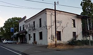
Oso Hall Museum in Bear Valley
|
|||||||||
| Country | |||||||||
| State | |||||||||
| County | Mariposa County | ||||||||
| Area | |||||||||
| • Total | 2.44 sq mi (6.32 km2) | ||||||||
| • Land | 2.44 sq mi (6.32 km2) | ||||||||
| • Water | 0.00 sq mi (0.00 km2) 0.1% | ||||||||
| Elevation | 2,054 ft (626 m) | ||||||||
| Population
(2020)
|
|||||||||
| • Total | 156 | ||||||||
| • Density | 63.9/sq mi (24.68/km2) | ||||||||
| Time zone | UTC-8 (Pacific (PST)) | ||||||||
| • Summer (DST) | UTC-7 (PDT) | ||||||||
| ZIP Code |
95338 (Mariposa)
|
||||||||
| FIPS Code | 06-04730 | ||||||||
| GNIS feature ID | 1659693 2582941 |
||||||||
|
|||||||||
Bear Valley is a small community in Mariposa County, California, United States. It's known as a census-designated place, which means it's a special area defined by the government for counting people. Bear Valley is located about 10.5 miles (17 km) south-southeast of Coulterville. It sits at an elevation of 2,054 feet (626 meters) above sea level. This historic spot is recognized as California Historical Landmark #331. In 2020, 156 people lived in Bear Valley.
Contents
History of Bear Valley
Bear Valley has had many names over the years! It was first called "Haydenville" to honor gold miners David, Charles, and William Hayden. Later, it became "Biddle's Camp" and "Biddleville" after William C. Biddle. Then, it was named "Simpsonville" for a local merchant named Robert Simpson. Finally, it was called "Johnsonville" to honor John F. Johnson. The name "Bear Valley" officially stuck in 1858.
The community had a post office called Haydenville that opened before 1851 but closed in 1852. The Bear Valley post office operated for many years, from 1858 to 1912, then again from 1914 to 1919, and finally from 1933 to 1955.
Gold Rush and John C. Frémont
In 1847, John C. Frémont, a famous explorer and military officer, decided to buy land in California. He ended up with a large area called Rancho Las Mariposas, which was about 44,387 acres (179.67 km²) in the southern Sierra Nevada foothills. This land included the area around Bear Valley.
When the California Gold Rush began in 1848, Frémont found that his land was rich with gold! His mining operations became very successful, especially in Bear Valley. At its busiest, Bear Valley had a population of about 3,000 people.
During the 1850s and 1860s, when Frémont's Pine Tree and Josephine Mines were producing a lot of gold, he built a fancy hotel called Oso House. Sadly, like many buildings from that time, it burned down later in the 1800s. Frémont also lived and worked in Bear Valley. His large home was nicknamed the Little White House, but it also burned down in 1866.
Geography of Bear Valley
Bear Valley is located in the west-central part of Mariposa County, right in the foothills of the Sierra Nevada mountains. California State Route 49 is a main road that goes through the community. This road leads southeast about 11 miles (18 km) to Mariposa, which is the main town of the county. It also goes northwest about 15 miles (24 km) through the Merced River canyon to Coulterville.
According to official measurements, Bear Valley covers about 2.44 square miles (6.32 km²) of land. A very tiny part, about 0.001 square miles (0.0026 km²), is water.
Population of Bear Valley
| Historical population | |||
|---|---|---|---|
| Census | Pop. | %± | |
| 2010 | 125 | — | |
| 2020 | 156 | 24.8% | |
| U.S. Decennial Census | |||
The population of Bear Valley has changed over the years. In 2010, the community had 125 residents. By the 2020 census, the population had grown to 156 people. This means that more people are choosing to live in this historic California location.
See also
 In Spanish: Bear Valley (condado de Mariposa) para niños
 | Stephanie Wilson |
 | Charles Bolden |
 | Ronald McNair |
 | Frederick D. Gregory |


