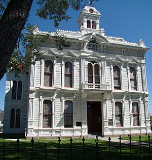
Mono County, California facts for kids
Quick facts for kids
Mono County, California
|
|||
|---|---|---|---|
| County of Mono | |||
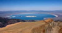
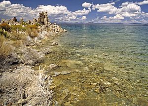
Mono Lake, the dominant geographical feature in Mono County
|
|||
|
|||
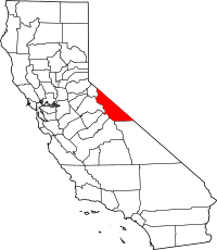
Location in the state of California
|
|||
| Country | United States | ||
| State | California | ||
| Region | Eastern California | ||
| Founded | April 21, 1861 | ||
| Named for | Mono Lake, which is derived from Monachi, a Yokutsan name for native peoples of the Sierra Nevada | ||
| County seat | Bridgeport | ||
| Largest city | Mammoth Lakes | ||
| Government | |||
| • Type | Council–CAO | ||
| • Body | Board of Supervisors | ||
| Area | |||
| • Total | 3,132 sq mi (8,110 km2) | ||
| • Land | 3,049 sq mi (7,900 km2) | ||
| • Water | 83 sq mi (210 km2) | ||
| Highest elevation | 14,252 ft (4,344 m) | ||
| Population
(2020)
|
|||
| • Total | 13,195 | ||
| • Density | 4.2130/sq mi (1.6266/km2) | ||
| GDP | |||
| • Total | $1.312 billion (2022) | ||
| Time zone | UTC-8 (Pacific Time Zone) | ||
| • Summer (DST) | UTC-7 (Pacific Daylight Time) | ||
| Area code | 530, 442, 760 | ||
| Congressional district | 3rd | ||
Mono County is a beautiful area in the eastern part of California. It's known for its stunning natural beauty. In 2020, about 13,195 people lived here. This makes it one of the less populated counties in California. The main town and county seat is Bridgeport.
Mono County is located east of the Sierra Nevada mountains. It sits between Yosemite National Park and the state of Nevada. The largest town is Mammoth Lakes. It is located at the base of Mammoth Mountain. Other popular spots like June Lake are famous for skiing and fishing.
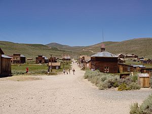
In the middle of the county is Mono Lake. This lake is very important for millions of birds. These birds either migrate through or nest there. The lake is in a wild, natural setting. It has unique rock formations called tufa towers. These towers rise out of the salty water. Mono County is also home to Bodie. Bodie is an old gold rush ghost town. It is now a California State Historic Park.
Contents
History of Mono County
Mono County was created in 1861. It was formed from parts of Calaveras, Fresno, and Mariposa counties. Later, in 1864, a part of northern Mono County helped form Alpine County. In 1866, some land was also given to Inyo County.
The county gets its name from Mono Lake. The lake was named in 1852 after a Native American tribe. This tribe was the Mono people, a Paiute group. They used to live in the Sierra Nevada mountains. Their neighbors, the Yokuts, called them monachie. This means "fly people". They used fly larvae as a main food source and for trading.
Not much is known about the very first people who lived in the county. Archeologists have found little evidence. However, the Kuzedika, a group of Paiute, had lived there for many generations. They were hunter-gatherers and spoke a language related to Shoshone.
Geography and Natural Features
Mono County covers a total area of about 3,132 square miles. Most of this area, about 3,049 square miles, is land. The remaining 83 square miles is water.
The highest point in Mono County is White Mountain Peak. This peak is 14,252 feet tall. It is the third-highest peak in all of California.
Neighboring Counties
Mono County shares borders with several other counties:
- Inyo County to the south
- Fresno County to the southwest
- Madera County to the southwest
- Tuolumne County to the west
- Alpine County to the northwest
- Douglas County, Nevada to the north
- Lyon County, Nevada to the northeast
- Mineral County, Nevada to the east
- Esmeralda County, Nevada to the southeast
Protected Natural Areas
A large part of Mono County is made up of protected natural areas. These include:
- Inyo National Forest (part of it)
- Humboldt–Toiyabe National Forest (part of it)
- Granite Mountain Wilderness (California)
Population and Demographics
The population of Mono County has changed over the years.
| Historical population | |||
|---|---|---|---|
| Census | Pop. | %± | |
| 1870 | 430 | — | |
| 1880 | 7,499 | 1,644.0% | |
| 1890 | 2,002 | −73.3% | |
| 1900 | 2,167 | 8.2% | |
| 1910 | 2,042 | −5.8% | |
| 1920 | 960 | −53.0% | |
| 1930 | 1,360 | 41.7% | |
| 1940 | 2,299 | 69.0% | |
| 1950 | 2,115 | −8.0% | |
| 1960 | 2,213 | 4.6% | |
| 1970 | 4,016 | 81.5% | |
| 1980 | 8,577 | 113.6% | |
| 1990 | 9,956 | 16.1% | |
| 2000 | 12,853 | 29.1% | |
| 2010 | 14,202 | 10.5% | |
| 2020 | 13,195 | −7.1% | |
| 2023 (est.) | 13,066 | −8.0% | |
| U.S. Decennial Census 1790–1960 1900–1990 1990–2000 2010 2020 |
|||
Life Expectancy in Mono County
In June 2021, U.S. News & World Report ranked Mono County very high. It had the third best life expectancy in the United States. People living there were expected to live to about 96.5 years old.
Population Details from 2020 Census
In 2020, the population of Mono County was 13,195 people.
- About 65.77% of the population was White (not Hispanic).
- About 26.58% of the population was Hispanic or Latino (of any race).
- Other groups included Black or African American, Native American, Asian, and Pacific Islander.
- About 3.80% of people identified as being of two or more races.
Transportation and Travel
Mono County has several important roads and ways to get around.
Main Highways
These are the major roads that pass through Mono County:
 U.S. Route 6
 U.S. Route 395
 State Route 89
 State Route 108
 State Route 120
 State Route 158
 State Route 167
 State Route 168
 State Route 182
 State Route 203
 State Route 266
 State Route 270
Public Transport Options
You can travel by bus in Mono County. The Eastern Sierra Transit Authority runs buses along U.S. 395. They also have local services in Mammoth Lakes. These buses can take you as far south as Lancaster, California and north to Reno, Nevada.
Another bus service is the Yosemite Area Regional Transit System (YARTS). This bus also travels along U.S. 395. It goes from Mammoth Lakes to Lee Vining. From there, it enters Yosemite National Park.
Airports in Mono County
There are several small airports for private planes. These include Bryant Field near Bridgeport, Mammoth Yosemite Airport, and Lee Vining Airport.
In December 2021, a new option for air travel started. United Airlines began offering seasonal flights. These flights go to San Francisco, Los Angeles, and Denver. These flights use the Eastern Sierra Regional Airport in Bishop. This airport helps people in southern Mono County travel by air.
Communities in Mono County
Mono County has one official town and several other communities.
Town
Census-Designated Places (CDPs)
These are areas that are like towns but are not officially incorporated.
- Aspen Springs
- Benton
- Bridgeport (This is the county seat)
- Chalfant
- Coleville
- Crowley Lake
- June Lake
- Lee Vining
- McGee Creek
- Mono City
- Paradise
- Sunny Slopes
- Swall Meadows
- Topaz
- Twin Lakes
- Virginia Lakes
- Walker
See also
 In Spanish: Condado de Mono para niños
 | Toni Morrison |
 | Barack Obama |
 | Martin Luther King Jr. |
 | Ralph Bunche |


