Yokuts facts for kids
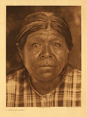
Chukchansi Yokuts woman,
photo by Edward Curtis, 1924 |
|
| Total population | |
|---|---|
| 6,273 alone and in combination (2010) | |
| Regions with significant populations | |
| Languages | |
| English, Yokuts language | |
| Religion | |
| traditional tribal religion, Christianity, Kuksu religion, previously Ghost Dance | |
| Related ethnic groups | |
| Maidu, Miwok, Ohlone, and Wintu peoples |
The Yokuts (also called Mariposas in the past) are a group of Native Americans. They originally lived in central California. Before Europeans arrived, there were about 60 Yokuts tribes. They spoke several languages that were all related.
The word Yokuts can mean one person or many people. Some descendants prefer to use their specific tribal names. They feel that "Yokuts" was a name given to them by settlers and historians. The main groups of Yokuts include the Foothill Yokuts, Northern Valley Yokuts, and Southern Valley Yokuts.
Contents
History of the Yokuts People
The name "Yokuts" means "people." Each tribe has its own stories about how the world and their land were created. Many of these stories are similar.
One creation story tells of a time when water covered everything. An eagle and a crow flew above the water. They asked a duck to bring up mud from the water. The duck did, and this mud became the land of the Yokuts. This land included the Sierra Nevada Mountains and the Coast Mountain Range. The crow and the eagle are still important symbols in Yokuts religious events today.
Life Before European Contact
Life for the Yokuts was generally peaceful. In 1770, when the Spanish first arrived, there were over 60 tribes. Each tribe likely had 400 to 600 or more people.
In Yokuts culture, men and women had different jobs. Men usually hunted, fished, and built things. Women gathered food, took care of the home, and raised children. Getting a divorce was not hard. It could happen for reasons like cheating, being lazy, or not being able to have children.
Yokuts people showed their artistic skills through music, singing, and painting. Basket making was also a big part of their art. They wove beautiful designs and pictures into their baskets. They also expressed themselves with tattoos and body piercings.
The Yokuts had two main religious ceremonies. These were the annual mourning rite and the first fruit rite. Shamans were very important to the Yokuts. People believed shamans had special powers. They helped lead ceremonies and treated sick people. Shamans could use their power for good or for bad. If they used it for bad, they could be punished.
Changes During European Contact
The Yokuts first met Europeans in 1772. Spanish soldiers were exploring the area. In the 1800s, the Spanish started building missions. As the missions grew, they forced Yokuts people to work on farms. The work was very hard, and many Native Americans died from disease and abuse.
As the number of workers decreased, the missions moved further inland. They forced more people they met to convert to Christianity and work.
In 1833, British fur traders brought malaria to the area. The disease spread quickly among the native people. This made the Yokuts population much smaller. Then, gold was discovered, bringing even more foreigners.
The Gold Rush happened in California in the 1800s. The 1850s were a very hard time for California Native Americans. Many European settlers came to their lands. They took land and caused many deaths. The Gold Rush left the Yokuts with little land and a much smaller population.
In 1853, malaria spread again, killing more people. By 1854, the remaining Yokuts were forced to move to the Fort Tejon Reservation. A few years later, white settlers attacked the reservation. Most of the people living there were killed. By 1859, the reservation was empty. The Tule reservation was set up in 1873, and many Yokuts moved there.
Disease, violence, and forced moves greatly reduced the Yokuts population. Today, their numbers are much lower than they once were.
Population
Experts have different ideas about how many Native Americans lived in California before Europeans arrived. In 1925, Alfred L. Kroeber estimated that 18,000 Yokuts lived in 1770. Other researchers later suggested the number was much higher, possibly around 70,000. They believe the Yokuts had one of the largest populations in North America before European contact.
After winning the Mexican War, the U.S. government took control of California. They signed treaties with Native American tribes. These treaties would have set aside land for reservations. However, the U.S. Senate secretly voted against these treaties in 1852. The results of this vote were not made public until 1905.
California's new state government took a different approach. In 1851, Governor Peter Burnett said that if Native Americans were not moved, a "war of extermination" would continue. This meant a war to wipe out the Native American people.
Over the next 50 years, settlers and the California State Militia fought against the Yokuts and other tribes. This period is known as the Californian Genocide. The Yokuts population dropped by about 93% between 1850 and 1900. Many survivors were forced into a type of forced labor.
Today, about 2,000 Yokuts are part of tribes officially recognized by the government. Another 600 Yokuts are believed to belong to tribes that are not yet recognized. Many of them live on reservations that have casinos. These casinos have been very important for providing jobs, money, and healthcare to the Yokuts people.
Territory
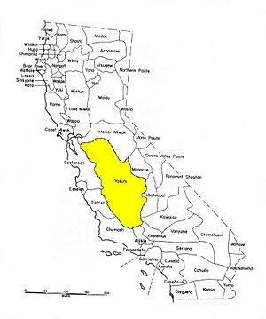
Yokuts tribes lived in the San Joaquin Valley. This area stretches from the Sacramento-San Joaquin River Delta in the north to Bakersfield in the south. It also included the nearby foothills of the Sierra Nevada mountains to the east.
In the northern part of the Yokuts region, some tribes lived in the foothills of the Coast Range to the west. There is also proof that Yokuts lived in the Carrizo Plain. They created rock art in the Painted Rock area.
Language
The Yokutsan languages are part of the Penutian language family.
Diet
The Yokuts used spears, basket traps, and other tools to hunt animals. They hunted birds, ducks, rabbits, turtles, and various fish. They also ate mussels and wasp grubs. They hunted larger animals like deer, elk, and antelope less often.
Their main food was made from acorn mash. They also gathered tule roots and iris bulbs to make flour. Other foods they found included manzanita berries, pine nuts, and seeds. They grew tobacco using a simple farming method. They got salt from salt grass.
Communities
Yokuts Tribes
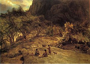
Here are some of the many Yokuts tribes:
Delta Yokuts
- Tarkumne - South bank of Carquinez Strait, from Rodeo to Martinez.
- Bolbumne - Antioch and Brentwood areas.
- Yachicumne - Stockton area and along the lower Calaveras River.
- Laquisumne - From the junction of the Mokelumne and Cosumnes Rivers south to Stockton.
- Apelumne - South and east of Stockton, including Escalon, Manteca, French Camp, and Lathrop.
- Yalesumne - From the Tuolumne River to north of the Stanislaus River.
- Hunezumne - Stockton area.
- Chelumne - Exact location in the delta is unknown.
- Chucumne - Between the San Joaquin River and Stockton.
- Cosumne - On the Cosumnes River from its junction with the Mokelumne.
- Mokelumne - On the Mokelumne River from its junction with the Cosumnes to the foothills.
Northern Valley Yokuts
- Hulpumne - Byron to Tassajara.
- Cholbumne - Byron to just south of Tracy.
- Hoyumne - West of San Joaquin River and south of Tracy.
- Miumne - Orestimba Creek Basin extending south to the Garzas Creek Basin.
- Kahwatchwah - San Joaquin River around the Mendota, Firebaugh, and Los Banos areas.
- Honoumne - West of the San Joaquin River between the Kahwatchwah and the Miumne.
- Tucuyu - South of the Kahwatchwah on Fresno and Fish Sloughs.
- Walakumne - Between the Stanislaus and Tuolumne Rivers.
- Suenumne - Lower Stanislaus River.
- Tuolumne - Lower Stanislaus River.
- Ausumne - Lower Merced River.
- Chulumne - Sand plains southwest of Stockton.
- Chauchela (Chowchilla) - Chowchilla River from the San Joaquin River to the Sierra Nevada foothills.
- Heuche - Fresno River, from its junction with the San Joaquin River to the foothills.
- Hoyumne - San Joaquin River from Herndon to Cottonwood Creek.
- Pitkache (Pitkachi) - San Joaquin River from Mendota Pool to Herndon.
Southern Valley Yokuts
- Tache (Tachi) - North and west shores of Tulare Lake.
- Apiche - North of Murphy Slough.
- Wimilche - Along the north bank of the Kings River near Laton.
- Nutúnutu - Along the south bank of the Kings River near Laton.
- Itecha (Aitecha) - South bank of Kings River near Sanger.
- Wéchikit - North bank of Kings River east of Sanger.
- Chunut - Northeastern shore of Tulare Lake.
- Talumne - Along Cross, Mill, and Packwood Creeks.
- Gáwea - North bank of the Kaweah River from Terminus Dam to Venice Hills.
- Yokodo - South bank of the Kaweah River from Exeter to the foothills.
- Wólase - Area around Cameron Creek east of Visalia.
- Choinok - Junction of Outside and Deep Creeks south to Tulare.
- Wowol - Southeastern shore of Tulare Lake.
- Koyete - Tule River from Highway 99 to Porterville.
- Yowlumne - Lower Kern River/Bakersfield area.
- Tuhoumne - Lower Kern River downstream from the Yowlumne.
- Halaumne (Hometwole) - Northern and western shores of Kern Lake.
- Tulumne - The south, west, and north sides of Buena Vista Lake.
Foothill Yokuts
- Gashou - Foothills between the San Joaquin and Kings Rivers.
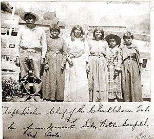
- Chukchanse (Chuckchansi) - Fresno River in the foothills above the Heuche.
- Dalinche - Coarsegold and O'Neals area.
- Kechaye - South side of the San Joaquin River upstream from the Dumna.
- Tolteche - On both sides of the San Joaquin River upstream from the Kechaye.
- Dumna - San Joaquin River from Millerton.
- Éntimbits - Dunlap area.
- Chukimena - Yokuts Valley.
- Choinumne - Kings River around its junction with Mill Creek.
- Michahi - South of Choinumne on Mill Creek.
- Páhdwishe (Balwishe) - On the Kaweah River centered around Camp Potwishe.
- Wuksache - North of the Páhdwishe around Badger.
- Wukchumne - Kaweah River between Farmersville area to Terminus Dam.
- Bancalache - Deer Creek, Kernville, Lake Isabella.
- Yáudanche - North Fork Tule River.
- Hoeynche (Buknínuwad) - Upper Deer Creek, South Fork Tule River.
- Kumachese - White River area.
- Paleumne - Poso Creek south to Kern River.
Contemporary Tribes
- Santa Rosa Rancheria (Tachi)
- Picayune Rancheria of Chukchansi Indians
- Table Mountain Rancheria (Mono)
- Tejon Indian Tribe of California
- Tule River Indian Tribe of the Tule River Reservation
- Tuolumne Rancheria
The Wukchumni and Choinumni communities today are not yet officially recognized by the federal government.
Trading Routes
The Yokuts tribe traded with other Native American tribes in California. This included coastal peoples like the Chumash tribe. They traded plant and animal products.
Other items traded by the Yokuts included salts, soap stones, and obsidian. They used marine shells as a form of money. This shows they had a working money system.
Disagreements within the Chukchansi Tribe
The Chukchansi tribe near Yosemite has faced disagreements about who belongs to the tribe. These issues have sometimes affected how casino profits are shared. In late 2014, disagreements led to a situation at the Chukchansi Gold Resort & Casino. As a result, a judge ordered the casino to close for a while. The casino reopened on December 31, 2015. A formal Grand Reopening Ceremony took place on January 15, 2016.
Notable Yokuts
- Estanislao
- Clay James
Tribal Government
Each Yokuts tribe has a Head Chief, called a Winatun, and a Village Chief.
Gallery
See also
 In Spanish: Yokut para niños
 | Toni Morrison |
 | Barack Obama |
 | Martin Luther King Jr. |
 | Ralph Bunche |


