
Byron, California facts for kids
Quick facts for kids
Byron
|
|
|---|---|

Byron sign
|
|

Location in Contra Costa County and the state of California
|
|

Byron
Location in the United States
|
|
| Country | |
| State | |
| County | Contra Costa |
| Area | |
| • Total | 6.52 sq mi (16.89 km2) |
| • Land | 6.52 sq mi (16.89 km2) |
| • Water | 0.00 sq mi (0.00 km2) 0% |
| Elevation | 33 ft (10 m) |
| Population
(2020)
|
|
| • Total | 1,140 |
| • Density | 174.82/sq mi (67.50/km2) |
| Time zone | UTC-8 (Pacific) |
| • Summer (DST) | UTC-7 (PDT) |
| ZIP code |
94514
|
| Area code | 925 |
| FIPS code | 06-09346 |
| GNIS feature IDs | 238290, 2407934 |
Byron is a small community in Contra Costa County, California, United States. It's known as a "census-designated place" (CDP), which means it's a community that is counted in the census but isn't officially a city. In 2020, about 1,140 people lived there.
Contents
History
Byron's story began with a large piece of land. In 1835, the King of Spain gave this land to Jose Noriega. Later, in 1841, some of the first American settlers from the east, known as the Bidwell-Bartelson wagon train, arrived in the area.
Byron got its first post office in 1878. The town was named after an employee of a railroad company.
During World War II in 1942, many families of Japanese descent living in Byron were forced to leave their homes by the U.S. government. They were moved to a place called the Turlock assembly center.
In 1960, a special center for young people was built near Byron. It was called the Orin Allen Youth Rehabilitation Center, but most people knew it as the Boys' Ranch. This center was for young people who had made mistakes. It aimed to help them get back on the right track, rather than just keeping them locked up. The center had dorms, classrooms, and sports areas.
Geography and Climate
Byron covers about 6.5 square miles (16.8 square kilometers) of land. It is located about 5.5 miles (8.8 kilometers) southeast of Brentwood.
Climate
Byron has a climate with hot and dry summers. In January, the average high temperature is around 55 degrees Fahrenheit (13 degrees Celsius). In July, it can reach about 93 degrees Fahrenheit (34 degrees Celsius). Byron is also known for being windy, and sometimes you can even see dust devils! This type of weather is called a "warm-summer Mediterranean climate."
=Images for kids
-
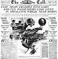
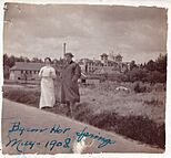
A newspaper reporting a train accident in Byron in 1902.
-
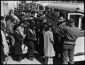
Families leaving Byron during World War II.
-
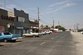
Main Street in Byron, California, in 2008.


Byron Hot Springs Resort
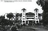
Byron is also home to the historic Byron Hot Springs, which used to be a famous resort. It was a popular getaway for movie stars and famous athletes in the early 1900s. The resort was built around 57 natural hot springs.
The first hotel was built in 1889, but it burned down in 1901. A second hotel was built, but it also burned down in 1912. The third and final hotel, a strong brick building, opened in 1914.
In 1938, the resort closed. During World War II, the government used it as a military camp called Camp Tracy. After the war, the Greek Orthodox Church bought it in 1947 and used it as a monastery for a few years. Over time, it changed owners many times. In 2008, there were plans to fix up the old resort, and as of 2021, a website still shows plans for its restoration.
Sadly, a smaller building on the property burned down in 2005, and the main hotel also had some fire damage, but it still stands today.
Pictures of Byron Hot Springs
- Byron Hot Springs
-
The second Byron Hot Springs Hotel, 1901–1912.
-
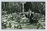
Byron Hot Springs in 1908.
-
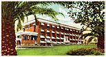
A postcard of Byron Hot Springs from 1914.
-
Another postcard of Byron Hot Springs, from 1923.
-
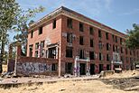
Byron Hot Springs in 2008.


Transportation
Byron Airport
In 1993, Contra Costa County started building a new airport south of Byron. Byron Airport officially opened in 1994. The airport covers a large area of land, with some of it set aside to protect endangered animals like the San Joaquin kit fox.
This airport is the home base for the Patriots Jet Team, a famous group that performs amazing air shows with jet planes. Sometimes, the airport has also been used for illegal drag races.
See also
 In Spanish: Byron (California) para niños
