
Brentwood, California facts for kids
Quick facts for kids
City of Brentwood
|
|||
|---|---|---|---|

Gateway to downtown Brentwood
|
|||
|
|||

Location of Brentwood in Contra Costa County, California.
|
|||

Brentwood, California
Location in the United States
|
|||
| Country | United States | ||
| State | California | ||
| County | Contra Costa | ||
| Incorporated | January 21, 1948 | ||
| Named for | Brentwood, Essex, England | ||
| Area | |||
| • Total | 14.87 sq mi (38.50 km2) | ||
| • Land | 14.87 sq mi (38.50 km2) | ||
| • Water | 0.00 sq mi (0.00 km2) 0.13% | ||
| Elevation | 79 ft (24 m) | ||
| Population | |||
| • Estimate
(2024)
|
65,350 | ||
| • Density | 4,394.75/sq mi (1,696.67/km2) | ||
| Time zone | UTC-8 (PST) | ||
| • Summer (DST) | UTC-7 (PDT) | ||
| ZIP code |
94513
|
||
| Area code(s) | 925 | ||
| FIPS code | 06-08142 | ||
| GNIS feature IDs | 277479, 2409902 | ||
| Website | brentwoodca.gov | ||

Brentwood is a city in Contra Costa County, California, in the United States. It's part of the East Bay area, which is near the famous San Francisco Bay Area. In 2022, about 66,854 people lived here. That's a huge jump from 23,302 people in 2000!
Brentwood was first settled by people from Europe in the late 1800s. It's still known for its farm products like cherries, corn, and peaches. However, over time, many farms have been replaced by new homes and neighborhoods. Brentwood has grown a lot since 1990, becoming more of a residential city where people live.
Contents
Discovering Brentwood: A City Guide
A Look Back: History of Brentwood
.jpg)
Brentwood was built on land that once belonged to John Marsh. He was an early settler in Contra Costa County. Marsh bought the land, called Rancho Los Méganos, in 1837 from Jose Noriega. John Marsh was a very rich man in California. He helped California become independent from Mexico and join the United States.
Marsh wrote letters about how great California was for farming. These letters were printed in newspapers back East. This led to the first wagon trains coming to California! Marsh even let new arrivals stay on his ranch until they found their own homes. Rancho Los Méganos became the end point of the California Trail. Brentwood was named after Marsh's family home, a town called Brentwood in England.
Brentwood got its first post office in 1878. The city officially became a city in 1948.
A British company, Balfour, Guthrie & Co., bought John Marsh's ranch in 1910. They also bought other farms in California. In 1910, they built the Brentwood Hotel. It was torn down in 1967 and replaced by a gas station.

The old Brentwood water tower is a symbol of how the city has changed. It used to be for water, but now it's a cell phone tower. This tall landmark is on Walnut Boulevard. The city's water is now kept in big tanks on hills outside the city.
Brentwood is surrounded by 11,000 acres of protected farmland. This land is still used for farming.
In the 1990s, many stores were built near the border of Brentwood and Antioch. A large outdoor shopping center called The Streets of Brentwood opened in 2008.
The city started building a new civic center in 2009. This project cost $60 million and finished in 2012. It includes a new City Hall, a community center, and a parking garage. The community center has rooms for arts, crafts, dance, and exercise. The new buildings are designed to be energy-efficient.
Early People: Indigenous History
Brentwood was once home to the Julpuns. They were Native Americans who lived in the East Bay area. The Julpun people were part of the Bay Miwok tribes. They spoke a language related to the Eastern Miwok language.
Bay Miwok villages usually had 50 to 200 people. They built their villages along creeks because the creeks had lots of fish. The Julpun people believed that everything in nature had a spirit. They thought Mt. Diablo, which they called Supremenenu, was where the world began. They used the top of Mt. Diablo for special religious gatherings.
Many Julpun people moved to Mission San Jose in the early 1800s. Later, in 1836, they left the mission and returned to their homeland. When John Marsh bought Rancho Los Meganos in 1837, it included the Julpun's territory. Some Julpun people may have worked for John Marsh on their old lands.
Today, the Julpun tribe members live around the Bay Area. Some live in groups, while others live in society and work to keep their culture alive. They are part of a larger group called the Federated Indians of Graton Rancheria.
Nature and Geography

From Brentwood, you can clearly see Mount Diablo. Brentwood is located on a flat area near the Sacramento-San Joaquin Delta. In the picture, Brentwood is on the right, and Antioch, California is on the left.
The East Bay Regional Park District manages parks and trails in the East Bay. You can find some of their trails and parks in Brentwood.
Brentwood covers about 14.81 square miles (38.36 square kilometers). Most of this is land. The western part of the city has rolling hills, oak trees, fruit orchards, and vineyards. There are also several public golf courses.
Brentwood's Climate
Brentwood has a climate that is a mix of Mediterranean and semi-arid. This means it has warm, dry summers and mild, wet winters. Because of Mt. Diablo, Brentwood gets less rain than some nearby areas. The wet season is usually from October to April. Summer heat often cools down quickly in the late afternoon because of a breeze from the Delta.
Learning and Libraries
Public Schools
Brentwood has many public schools. The city is served by the Brentwood Union School District (BUSD) and the Liberty Union High School District (LUHSD). There are 9 elementary schools, 3 middle schools, and 4 high schools.
Many schools in the Brentwood Union School District have been named a California Distinguished School. This is a special honor given to only about five percent of California schools.
Heritage High School offers many advanced classes. It also has great performing arts programs and sports teams. Heritage High School is also a "solar school," meaning it uses solar panels to create electricity. This helps the environment and teaches students about renewable energy.
Community College
Los Medanos College has a campus in Brentwood called the Brentwood Center. This center is growing! It moved to a new, larger campus in 2021.
Public Library
Brentwood has a new public library! The old library building was replaced in 2017. The new library is about 20,000 square feet. It opened in 2018 and serves over 50,000 people.
The library has books and materials in both Spanish and English. You can also find DVDs, CDs, and audiobooks. The library offers many programs for all ages, including story times for babies and toddlers.
How People Live Here: Demographics
Brentwood's population has grown a lot over the years.
| Year | Population |
|---|---|
| 1950 | 1,729 |
| 1960 | 2,186 |
| 1970 | 2,649 |
| 1980 | 4,434 |
| 1990 | 7,563 |
| 2000 | 23,302 |
| 2010 | 51,481 |
| 2020 | 64,292 |
| 2024 (estimate) | 65,350 |
In 2010, about 67.9% of the people in Brentwood were White. About 6.6% were African American, and 7.9% were Asian. About 26.8% of the people were Hispanic or Latino.
Many families live in Brentwood. In 2010, about 48.8% of households had children under 18. The average household had about 3 people. The median age in Brentwood was 35.6 years old. This means half the people were younger than 35.6, and half were older.
Jobs and Growth: Economy
Farming is still important in Brentwood, but the city has become more suburban. Local wineries like Bloomfield and Hannah Nicole have become popular. Brentwood does not have much heavy industry.
Brentwood had a big economic growth period from 2000 to 2008. The population grew very quickly. New neighborhoods were built, some around new golf courses like Shadow Lakes and Deer Valley. These golf courses offer great views of Mt. Diablo.
The economy slowed down in 2009, like the rest of California. But new homes and communities started to appear again in 2010. In 2013, Brentwood's economy started to grow strongly again. This was helped by improvements in the Bay Area economy and new highway projects.
Brentwood is also working with two important research centers: Lawrence Livermore National Laboratory and Sandia National Laboratories. These labs are about 25 minutes south of Brentwood. Brentwood is part of i-GATE, a group that helps grow technology businesses connected to these labs.
Top Employers in Brentwood
Here are some of the biggest employers in Brentwood:
| # | Employer | Type of Business |
|---|---|---|
| 1 | Brentwood Union School District | Public Education |
| 2 | City of Brentwood | City Government |
| 3 | Liberty Union High School District | Public Education |
| 4 | The Home Depot | Retail Store |
| 5 | Safeway | Grocery Store |
| 6 | John Muir | Healthcare |
| 7 | Precision Cabinets | Manufacturing |
| 8 | Ellison Framing Inc. | Construction |
| 9 | Kohl's | Retail Store |
| 10 | WinCo Foods | Grocery Store |
Getting Around: Transportation
It can be hard to get around Brentwood without a car because public transportation is limited. The main roads often get crowded with people going to work.
A new highway, the John Marsh Heritage Highway (now California State Route 4), opened in 2008. It connects the western part of Brentwood directly to Antioch. State Route 4 passes by the edge of Brentwood. Other important roads include Vasco Road, which goes to Livermore, and the Byron Highway, which goes to Tracy.
Bus Service
Local bus service is provided by Tri Delta Transit. This bus system serves Eastern Contra Costa County.
- Tri Delta Transit Route 300X offers express bus service between Brentwood and the Antioch BART station on weekdays.
- Tri Delta Transit Route 391 provides local service between Brentwood and Pittsburgh Center Station, with stops at Antioch BART and Los Medanos College.
- The Brentwood Park & Ride is a main stop for several Tri Delta Transit routes.
Rail
A light rail system called eBart started service in August 2018. It connects East Contra Costa County to the wider BART system.
There is no passenger train service directly to Brentwood. The closest train stations are in Livermore (for Altamont Corridor Express) and Antioch (for Amtrak).
A freight-only train line goes through Brentwood. It's owned by Union Pacific Railroad. This line hasn't been used since the early 1990s, but Union Pacific plans to use it again in the future.
Airports
If you need to fly, the closest major airports are:
- Oakland International Airport
- San Francisco International Airport
- San Jose International Airport
- Sacramento International Airport
- Stockton Metropolitan Airport
There are also smaller airports nearby for private planes.
Fun Things to Do: Attractions and Lifestyle
Brentwood was named a "Playful City USA" for many years. This means the city helps its community stay active and healthy. Brentwood has many parks and miles of jogging trails.
The arts are important in Brentwood. The Brentwood Art Society holds events like the annual Art, Wine, and Jazz Festival. They also have an Artists Open Studio Tour and open mic nights. The Brentwood Theater Company puts on musicals and shows. A large art gallery opened in The Streets of Brentwood shopping center in 2014.
The Brentwood Parks and Recreation Department takes care of 72 city parks. Most of these are smaller parks, but some are larger than 10 acres.
Places to Visit
- East Contra Costa Historical Society and Museum
- Los Vaqueros Reservoir (a large lake)
- Marsh Creek Regional Trail (a path for walking and biking)
- Round Valley Regional Preserve (a nature preserve)
- Vasco Caves Regional Preserve (a nature preserve)
- Sacramento-San Joaquin River Delta (a large river delta)
- Brentwood Civic Center (the city's main government building)
- Streets of Brentwood shopping center
- John Marsh House (a historic home, not currently open to the public)
Farming Fun
- The Art, Wine, and Jazz Festival happens every August. You can try local wines and beers there.
- Many local farms have stands where you can buy fresh produce. Some even let you pick your own fruits! This is part of the "Harvest Time" farm tour.
- A farmers' market is held every Saturday morning in downtown Brentwood.
Images for kids
-
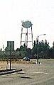
Original Brentwood water tower
Error: no page names specified (help). In Spanish: Brentwood (California) para niños
