
Los Vaqueros Reservoir facts for kids
Quick facts for kids Los Vaqueros Reservoir |
|
|---|---|
.jpg) |
|

Los Vaqueros Reservoir
Location in California

Los Vaqueros Reservoir
Location in the United States
|
|
| Location | Diablo Range, Contra Costa County, California |
| Coordinates | 37°49′13″N 121°44′02″W / 37.82025°N 121.7338°W |
| Type | reservoir |
| Basin countries | United States |
| Max. length | 2.5 mi (4.0 km) |
| Max. width | 2.5 mi (4.0 km) |
| Surface area | 1,400 acres (570 ha) |
| Average depth | 170 ft (52 m) |
| Max. depth | 170 ft (52 m) |
| Water volume | 160,000 acre⋅ft (0.20 km3) |
| Surface elevation | 524 ft (160 m) |
| Settlements | Brentwood, Livermore |
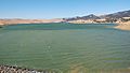
The Los Vaqueros Reservoir is a large lake located in northern California. It sits in the Diablo Range within Contra Costa County. This reservoir was finished in 1998 by the Contra Costa Water District (CCWD). Its main purpose is to provide clean drinking water for over 550,000 people. You can reach the reservoir by using Vasco Road, which connects the towns of Brentwood and Livermore.
Contents
History of Los Vaqueros Reservoir
The Los Vaqueros Reservoir gets its name from an old Mexican land grant from the 1800s. This land grant was called "Rancho Cañada de los Vaqueros." In Spanish, the word vaquero means "cowboy."
Since the 1870s, salty water from San Francisco Bay has sometimes entered the Sacramento-San Joaquin River Delta. This was a big worry for drinking water. The Contra Costa Water District (CCWD) was created in 1936 partly because of this problem. In 1977, a severe drought caused the water to become too salty for people to drink. CCWD had to limit how much fresh water its customers could use.
In 2010, a project began to make the dam taller. This increased the reservoir's storage from 100,000 acre-feet to 160,000 acre-feet of water. By early 2017, the reservoir held about 133,700 acre-feet (164,900,000 m3) of water.
Building the Reservoir
In 1988, people voted to approve money for the Los Vaqueros Reservoir project. This allowed the design and building to begin. It was a very big construction job. Besides building the $61 million dam, which was 192 feet (59 m) tall, the district also had to:
- Build 12.8 miles (20.6 km) of new road around the lake area. This cost $27 million.
- Move 20 electrical towers and 12 miles (19 km) of gas pipeline.
- Build a new $20 million pumping plant near Discovery Bay.
- Construct a new $12 million transfer station with powerful pumps.
- Lay 20 miles (32 km) of large pipelines (6 to 8 feet wide). These connected the new parts to the district's existing water system.
- Buy almost 20,000 acres (81 km2) of land for the dam and the surrounding area.
- Promise to protect the environment and old Native American sites.
Construction Timeline
- Building started on September 17, 1994.
- By 1996, Vasco Road was moved to go around the eastern side of the CCWD property. The old road was closed. Half of the pipeline from Old River was also done. The pump station was being built.
- The dam and most other main parts were finished by December 1997.
- The reservoir started filling with water in February 1998. It was full by January 1999, which was a year earlier than planned.
- A special ceremony to open the project happened in May 1998. The American Society of Civil Engineers called it the "Outstanding Civil Engineering Accomplishment" in the country that year.
2010-2012 Expansion Project
In March 2010, CCWD decided to increase the reservoir's capacity by 60,000 acre-feet (74,000,000 m3). The costs for this expansion would be paid by those who receive water from the district. They also had to make sure they protected sensitive wildlife areas. This expansion was planned to be finished in 2012.
On July 14, 2012, parts of the expanded project opened to the public:
- The dam was made taller by 34 feet (10 m), reaching a new height of 224 feet (68 m).
- The John Muir Interpretive Center was added at the north end of the reservoir.
- New trails and places for shoreline fishing were opened at the south end.
The company that expanded the reservoir used a special building method called Mechanically Stabilized Earth (MSE). This helped create the dam walls. This method used strong strips and concrete panels to build the dam quickly and save money.
The south end of the reservoir reopened in October 2012 after the marina was updated. In 2013, the water level reached 132,900 acre-feet (163,900,000 m3). Then, CCWD started using the water to help people during a recent drought. Heavy rains in late 2016 and early 2017 filled the reservoir to over 133,700 acre-feet (164,900,000 m3). This was the highest level ever recorded for the reservoir.
2017 Expansion Study
A group of 12 water agencies in the Bay Area agreed to study expanding the reservoir even more. They want to make the dam taller by another 55 feet (17 m), reaching a total height of 273 feet (83 m). If this happens, Los Vaqueros Dam would be the second-tallest dam in the Bay Area. The Warm Springs Dam on Lake Sonoma is already 319 feet (97 m) tall. This project would increase the reservoir's capacity from 160,000 acre-feet (200,000,000 m3) to 275,000 acre-feet (339,000,000 m3). It is estimated to cost about $800 million.
In August 2017, a newspaper reported that the cost had increased to $914 million. Six environmental groups wrote a letter supporting the expansion. These groups included Nature Conservancy and Audubon California. If the California Water Commission provides the money, building could start in 2022 and finish in 2026.
Recreation at the Reservoir
You can enjoy certain activities at Los Vaqueros Reservoir. These include boating and fishing. You can rent boats at the marina. However, you cannot bring your own boats into the area. Boats that use gasoline are not allowed. Swimming and wading in the water are also not allowed.
Hiking Trails
There are several hiking trails around the reservoir:
- Badger Pass and Oak Savannah Loop Trail: This trail is considered "Hard." It starts near the north end of the lake and is 7.9 miles (12.7 km) long. It goes up 2,125 feet (648 m) in elevation. You can hike, walk, enjoy nature, and watch birds here all year.
- Los Vaqueros Dam Trail: This trail is rated as "Moderate" difficulty.
- Los Vaqueros Shoreline Loop Trail: This trail is also rated as "Moderate" difficulty.
Watershed Description
The Los Vaqueros watershed is a large open space of 19,300 acres (78 km2) that surrounds the 1,500-acre (6.1 km2) reservoir. Water is pumped into the reservoir from a place called Old River in the Sacramento-San Joaquin Delta. This intake is located just east of Discovery Bay. Water is pumped into the reservoir when it is not very salty. This water is then used for drinking when the water in the Delta is too salty.
Water from the reservoir flows through a pipeline to the 48-mile (77 km) Contra Costa Canal. This canal carries water to six water treatment plants in the area. The reservoir can hold up to 160,000 acre-feet (200,000,000 m3) of water. The dam is made of earth and is 192 feet (59 m) high. It is 1,000-foot (300 m) long at the top and made from 2.7 million cubic yards of dirt.
The watershed also has a weather station called Mallory Ridge RAWS. It collects weather data on the ridge above the Marina. The staff at Los Vaqueros Watershed maintain it, and it is connected to the National Fire Weather System.
Other good things about the reservoir include storing water for dry times or emergencies. It also protects a large open space and offers fun activities like hiking and fishing. There are 55 miles (89 km) of hiking trails in the watershed. The watershed is open all year for fishing, hiking, and other activities. You can rent electric boats, but you cannot bring your own boats. Swimming is not allowed in the reservoir.
Future Expansion Plans
The idea of expanding Los Vaqueros to hold 275,000 acre-feet (339,000,000 m3) of water is being discussed again. This goal was first thought about when the reservoir was planned. It came up again in 2010 during the first expansion. Both times, the idea was put aside because CCWD could not find enough other agencies to help pay for it.
Currently, several public agencies are partners in planning for this third expansion. These include:
- Alameda County Water District
- Bay Area Water Supply and Conservation Agency
- Byron Bethany Irrigation District
- City of Brentwood
- East Bay Municipal Utility District
- East Contra Costa County Irrigation District
- Grassland Water District
- Santa Clara Valley Water District
- San Francisco Public Utilities Commission
- San Luis Delta Mendota Water Authority
- Zone 7 Water Agency
Wildlife Protection
The reservoir also helps protect almost 20,000 acres (81 km2) of wildlife habitat in Eastern Contra Costa County. This area is home to many rare, threatened, and endangered animals. These include fairy shrimp, bald and golden eagles, Alameda whipsnake, western pond turtle, California tiger salamander, California red-legged frog, San Joaquin kit fox, and the San Francisco dusky-footed wood rat. It also provides a home for hundreds of common plants and animals. Strict rules and a promise to protect the area help keep this site safe for wildlife.
As of February 17, 2017, seven trails on the Los Vaqueros property were temporarily closed. This was to protect possible golden eagle nests. Four pairs of eagles were showing nesting behavior. The number might change during the spring. More trails might close, or some might reopen, depending on the nests. These closures usually last until late May or June, when the young eagles are old enough to fly.
Visiting Los Vaqueros
The north entrance is about 7 miles (11 km) south of Brentwood on Walnut Blvd. This leads to the main parking area, the Interpretive Center, and the main hiking trails. The south entrance is off Vasco Road, north of Livermore. This leads to the marina area and four fishing piers. There is no road inside the property that connects the two entrances. Remember, you cannot bring outside boats or pets into the watershed.
Images for kids
-
The lake has boating and fishing
