
Diablo Range facts for kids
Quick facts for kids Diablo Range |
|
|---|---|
.JPG)
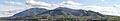
Mount Hamilton
|
|
| Highest point | |
| Elevation | 5,240 ft (1,600 m) |
| Dimensions | |
| Length | 180 mi (290 km) north-south from Carquinez Strait to Polonio Pass |
| Width | 20 mi (32 km) |
| Geography | |

Location in California
|
|
| Country | United States |
| State | California |
| Region | Central California |
| Range coordinates | 36°22′10.844″N 120°38′39.609″W / 36.36967889°N 120.64433583°W |
| Topo map | USGS San Benito Mountain |
The Diablo Range is a long chain of mountains in northern California, United States. It's part of the larger California Coast Ranges. This mountain range stretches from the eastern San Francisco Bay Area in the north all the way down to the Salinas Valley in the south.
Contents
Exploring the Diablo Range Geography
The Diablo Range starts near the Carquinez Strait in the north. It ends near Polonio Pass in the south. This is where State Route 46 crosses the Coast Ranges. To the northeast, you'll find the San Joaquin River. The San Joaquin Valley is to the southeast. To the southwest is the Salinas River. The Santa Clara Valley and San Francisco Bay are to the northwest.
The main ridgeline of the Diablo Range includes Mount Diablo and Mount Hamilton. Sometimes, people also include the East Bay Hills as part of the Diablo Range. These hills include the Briones Hills, Berkeley Hills, San Leandro Hills, Walpert Ridge, and Pleasanton Ridge.
Geologically, the Diablo Range is east of the Calaveras Fault. To its west are other mountain ranges. These include the Santa Cruz Mountains and the Santa Lucia Range. The East Bay Hills are located between the Calaveras Fault and the Hayward Fault.
The Diablo Range passes through many counties. These include Contra Costa, Alameda, Santa Clara, and San Benito counties. It also goes through San Joaquin, Stanislaus, Merced, Fresno, Monterey, Kings, and Kern counties.
How High Are the Mountains?
The average height of the Diablo Range is about 3,000 feet (914 meters). But a peak over 2,300 feet (701 meters) is considered quite high here. This is because much of the range has rolling grasslands and flat areas called plateaus. These plateaus are usually between 2,000 and 3,000 feet (610-914 meters) high.
Hills in the range can rise to about 1,000 feet (305 meters). Foothills, like those near the Santa Clara Valley, are typically 400 to 1,000 feet (122-305 meters) high. Canyons are often 300 to 400 feet (91-122 meters) deep. Valleys are usually deeper but not as steep.
Famous Peaks of the Diablo Range
The peaks and ridges in the Diablo Range stand out. They range from about 2,500 to over 5,200 feet (762-1,597 meters) tall. Some of the highest peaks are:
- Mount Diablo (3,849 feet or 1,173 meters)
- San Benito Mountain (5,241 feet or 1,597 meters)
- Mount Hamilton Ridge (4,230-4,260 feet or 1,289-1,300 meters)
- Mount Stakes (3,804 feet or 1,159 meters)

People and Roads in the Diablo Range

Two major highways run alongside the Diablo Range. U.S. Route 101 is to the west, and I-5 is to the east.
Many important roads and train lines cross through the mountains. These include:
- State Route 4 and BART (Yellow line) near Willow Pass.
- I-580 and the Altamont Corridor Express train at Altamont Pass.
- State Route 84 and I-680 in Sunol Valley.
- State Route 130 over Mount Hamilton.
- State Route 152 at Pacheco Pass, which will also be a route for future high-speed rail.
- State Route 198.
- State Route 41 at Cottonwood Pass.
- State Route 46 at Polonio Pass.
There's also a gravel road on San Benito Mountain. It's the highest road in the range, reaching over 5,000 feet (1,524 meters).
Most of the Diablo Range is not heavily populated. However, there are many towns and cities nearby. In the north, these include Antioch, Concord, Walnut Creek, Pleasanton, Livermore, Fremont, Milpitas, and San Jose. Further south, you'll find Los Banos and Hollister. Smaller towns like Coalinga and Kettleman City are also important as they are on routes crossing the mountains.

Parks and Protected Areas
Much of the Diablo Range is private ranch land. But there are several parks and protected areas where people can visit. These include:
- Mount Diablo State Park
- Alum Rock Park
- Grant Ranch Park
- Henry W. Coe State Park
- Laguna Mountain Recreation Area
- The BLM's Clear Creek Management Area
Some private lands are also protected by groups like the California Rangeland Trust. This helps keep the natural environment safe.
Nature in the Diablo Range
The Diablo Range doesn't get much rain. This is because it's located 10 to 50 miles (16-80 kilometers) inland from the ocean. Other coastal mountain ranges, like the Santa Lucia Range, block much of the moisture coming from the sea. Also, the average height of 3,000 feet (914 meters) isn't high enough to catch a lot of the moisture in the air.
Winters are mild with some rain. But summers are very dry and hot. Higher areas, above 2,500 feet (762 meters), get light to moderate snow in winter. The highest point, San Benito Mountain (5,241 feet or 1,597 meters), gets the most snow. Sometimes, once or twice every ten years, there can be a lot of deep snow that stays for a while.
There's an environmental concern in the southern part of the range. Old quicksilver (mercury) mines, which closed in the 1970s, caused mercury to get into local creeks. This mercury then flowed into the San Joaquin River and even reached the San Francisco Bay. These creeks are important for the local wildlife. Efforts are being made to clean up these areas.
Plants of the Diablo Range
The Diablo Range is part of the California interior chaparral and woodlands ecoregion. This means it's mostly covered by chaparral (a type of shrubland) and California oak woodlands. You can also find closed-cone pine forests on peaks above 4,000 feet (1,219 meters).
Many of the native grasses have been replaced by non-native grasses from the Mediterranean. But in spring, you can see beautiful wildflowers like Viola pedunculata and Dodecatheon pulchellum.
Along the streams, you'll find trees like bigleaf maple, white alder, and California sycamore. The most common trees are coast live oak and blue oak. There are also California buckeye and California black oak. You can find gray pine and the rarer Coulter pine at many elevations. Higher up, you might see knobcone pine, Jeffrey pine, and ponderosa pine.
Animals of the Diablo Range

The Diablo Range is a great place for raptors, like red-tailed hawks and golden eagles. Many golden eagles build their nests here.
Some rare animals also live in the range. The Bay checkerspot butterfly, which is a threatened species, lives here, especially near Mount Diablo. The California tiger salamander, another threatened species, lives in ponds throughout the range. You'll also find many northern Pacific rattlesnakes, ground squirrels, and hares.
Tule elk were brought back to Mount Hamilton between 1978 and 1981. They are slowly growing their numbers in Santa Clara and Alameda Counties. Black-tailed deer are also common. While pronghorn, grizzly bears, and wolves disappeared from the area in the 1800s, there are still many coyotes and healthy populations of mountain lions. You can also find bobcats and gray foxes, which rely on the chaparral habitat.
A special kind of millipede, called Illacme plenipes, lives only in the southern Diablo Range. It was first found in 1926, then not seen again until 2005. This millipede has more legs than any other known species, with one having 750 legs!
Images for kids
-
View of Mt. Diablo from Concord. Main peak at right, North Peak at left, Mt. Zion at center (scroll image L/R to view)
-
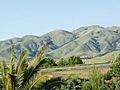
The south edge (mostly Monument Peak) of the Mission Ridge as seen from Milpitas.
-
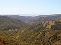
The southern end of Henry W. Coe State Park, near Gilroy
-
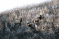
Three tule elk in Basking Ridge Park just north of U.S. Highway 101, which is a barrier to elk migration to the Coast Range
