
Milpitas, California facts for kids
Quick facts for kids
Milpitas, California
|
|||
|---|---|---|---|
 .jpg)   .JPG) Clockwise: View of Milpitas and Silicon Valley from the Diablo Range; Milpitas Grammar School; Great Mall/Main Transit Center; José María Alviso Adobe; City Hall
|
|||
|
|||

Location in Santa Clara County and the state of California
|
|||

Milpitas, California
Location in the United States

Milpitas, California
Location in California

Milpitas, California
Location in San Francisco Bay Area
|
|||
| Country | |||
| State | |||
| County | Santa Clara | ||
| Incorporated | January 26, 1954 | ||
| Government | |||
| • Type | Council–manager government | ||
| Area | |||
| • Total | 13.52 sq mi (35.01 km2) | ||
| • Land | 13.48 sq mi (34.91 km2) | ||
| • Water | 0.04 sq mi (0.10 km2) 0.36% | ||
| Elevation | 20 ft (6 m) | ||
| Population
(2020)
|
|||
| • Total | 80,273 | ||
| • Rank | 108th in California | ||
| • Density | 5,937.4/sq mi (2,292.9/km2) | ||
| Time zone | UTC−8 (Pacific) | ||
| • Summer (DST) | UTC−7 (PDT) | ||
| ZIP codes |
95035, 95036
|
||
| Area code(s) | 408/669 | ||
| FIPS code | 06-47766 | ||
| GNIS feature IDs | 1659759, 2411113 | ||


Milpitas is a city in Santa Clara County, California, located in Silicon Valley. The name "Milpitas" comes from Spanish and means "little cornfields." In 2020, about 80,273 people lived there. The city started from a large ranch called Rancho Milpitas, given to José María Alviso in 1835. Milpitas became an official city in 1954. Today, it is home to many high tech companies, making it an important part of Silicon Valley.
Contents
History of Milpitas
Milpitas was first home to the Tamien people, a group of Ohlone Indians. They lived in the San Francisco Bay Area for thousands of years, hunting and gathering food. Some Ohlone villages were located where Milpitas is today. Old graves found in 1993 showed that they traded with other tribes from Sacramento to Monterey.
During the late 1700s, Spanish explorers founded several missions in the Bay Area. Milpitas was a key stopping point between Mission San José de Guadalupe (in modern-day Fremont) and Mission Santa Clara de Asis (in modern-day Santa Clara). The land was divided into large ranches. One of these, Rancho Milpitas, was given to José María Alviso, who is considered the founder of Milpitas.
In the 1850s, many American farmers from places like England, Germany, and Ireland came to Milpitas. They farmed the rich land that used to be ranches. Some opened businesses on Mission Road, which is now Main Street. Later, in the 1870s and 1880s, Portuguese farmers from the Azores also came to farm the hillsides.
There's a story that in 1857, when the U.S. Postal Service wanted to open a post office, they considered naming it "Penitencia." But a local farmer, Joseph Weller, thought it sounded too much like "penitentiary" (a prison). He suggested "Milpitas" instead, after José María Alviso's ranch. That's how "Milpitas Township" got its name.
For over 100 years, Milpitas was a popular stop for travelers on the old Oakland−San Jose Highway. Many businesses, like hotels, saloons, and restaurants, opened there. Even in the early 1950s, Milpitas was a small farming town with only about 800 people.
On January 26, 1954, Milpitas officially became a city. This happened because the nearby city of San Jose was growing fast and Milpitas residents wanted to stay independent. When San Jose tried to take over Milpitas a few years later, the "Milpitas Minutemen" group formed to fight against it. Most Milpitas voters said "No" to San Jose taking over in an election in 1961. The city's official seal even includes an image of a Minuteman statue, like the American Revolutionary War soldiers who fought for independence.
In the 1950s, the Ford Motor Assembly Plant was built in Milpitas. This led to a lot of new homes and stores being built. The population grew from about 800 people in 1950 to over 62,000 by 2000. Milpitas changed from a rural town to a busy suburb of San Jose.
When the Ford plant moved to Milpitas in 1953, the city passed laws that made it hard for African American workers to live there, even though they worked at the plant. This meant these workers had to live in other cities or travel long distances. In 1961, Ben F. Gross, a civil rights leader, became the first black city councilman in Milpitas. In 1966, he became California's first black mayor elected by the city's residents. He continued to fight for fairness and against San Jose trying to take over Milpitas.
The Ford plant closed in 1984. Later, it was turned into a large shopping mall called the Great Mall of the Bay Area, which opened in 1994. In 2004, Milpitas celebrated its 50th anniversary as a city.
Etymology
The name Milpitas comes from the Spanish word milpa, which means "cornfield." The "itas" part means "little," so Milpitas means "Place of little cornfields." The word milpa itself comes from older words meaning "agricultural field."
This name might have been used by José María Alviso for his ranch because there were small Native American gardens nearby. The soil in the area was very rich for farming.
Geography
Milpitas is in the northeastern part of the Santa Clara Valley, south of San Francisco. It's considered a suburb of San Jose in the South Bay area.
The city covers about 13.5 square miles (35 square kilometers). Most of this is land, with a small amount of water. The average height above sea level in Milpitas is about 20 feet (6 meters). Some areas in the west are almost at sea level, while the eastern hills can be much higher. The highest point in Milpitas is a 1,289-foot (393-meter) peak in the southeastern foothills.
To the east of Milpitas are high hills and mountains, which are part of the Diablo Range. Monument Peak is a well-known summit in these hills. It's where TV stations broadcast to the Bay Area.
Many creeks flow through Milpitas from the hills and empty into the San Francisco Bay. These include Calera Creek, Arroyo de los Coches, Penitencia Creek, and Piedmont Creek.
Urban Layout

Milpitas is divided into three main parts by two major highways, I-680 and I-880. West of I-880, you'll find mostly businesses and factories. Between I-880 and I-680, there's an industrial area to the south and homes to the north. East of I-680, there are more homes and undeveloped mountains.
Milpitas doesn't have one big "downtown" center. Instead, it has several smaller shopping areas near neighborhoods. The oldest part of Milpitas, called "Midtown," is where Main and Abel Streets run side by side. Here you'll find the post office, a church, the Milpitas Public Library (which used to be the old Milpitas Grammar School), and the Senior Center. The Milpitas City Hall is in a different area, at the intersection of Milpitas and Calaveras Boulevards.
Environment
Sometimes, Milpitas can have smelly air. This smell comes from nearby bay salt marshes, the Newby Island landfill, and the San Jose sewage treatment plant. It's usually strongest in the autumn, especially west of I-880, because of the wind direction. The city tries to fix this problem and asks residents to report any bad smells.
Local creeks and the San Francisco Bay have some water pollution from street runoff and industrial waste. In the past, Milpitas creeks were great for fishing for steelhead, but pollution from city growth and factories harmed the fish starting in the 1950s.
Climate
Milpitas has a warm Mediterranean climate. This means it has warm, sunny weather with not many extreme temperatures. Most of the rain falls in the winter months. Winters are cool, with average temperatures between 41 and 59 degrees Fahrenheit (5 to 15 degrees Celsius). Summers are dry and warm, but usually not too hot, with most days in the low to mid-80s Fahrenheit (around 27-30 degrees Celsius). From June to September, there's very little rain.
| Climate data for Milpitas, California | |||||||||||||
|---|---|---|---|---|---|---|---|---|---|---|---|---|---|
| Month | Jan | Feb | Mar | Apr | May | Jun | Jul | Aug | Sep | Oct | Nov | Dec | Year |
| Record high °F (°C) | 79 (26) |
81 (27) |
89 (32) |
95 (35) |
101 (38) |
109 (43) |
108 (42) |
105 (41) |
109 (43) |
106 (41) |
85 (29) |
79 (26) |
109 (43) |
| Mean daily maximum °F (°C) | 58 (14) |
63 (17) |
68 (20) |
72 (22) |
76 (24) |
82 (28) |
84 (29) |
84 (29) |
82 (28) |
75 (24) |
65 (18) |
58 (14) |
72 (22) |
| Mean daily minimum °F (°C) | 41 (5) |
44 (7) |
46 (8) |
48 (9) |
53 (12) |
56 (13) |
58 (14) |
58 (14) |
56 (13) |
50 (10) |
45 (7) |
40 (4) |
50 (10) |
| Record low °F (°C) | 24 (−4) |
26 (−3) |
30 (−1) |
35 (2) |
37 (3) |
42 (6) |
47 (8) |
47 (8) |
42 (6) |
36 (2) |
21 (−6) |
19 (−7) |
19 (−7) |
| Average precipitation inches (mm) | 3.03 (77) |
2.84 (72) |
2.69 (68) |
1.02 (26) |
0.44 (11) |
0.10 (2.5) |
0.06 (1.5) |
0.07 (1.8) |
0.23 (5.8) |
0.87 (22) |
1.73 (44) |
2.00 (51) |
15.08 (383) |
People of Milpitas
Milpitas has grown a lot over the years. In 1960, there were about 6,572 people, and by 2020, the population had grown to 80,273. The city is very diverse, with a large Asian population. Many families live in Milpitas, and the average household size is about 3.34 people.
Economy

Many people in Milpitas work in the computer and electronics industries. While most residents work outside the city, many people from other cities come to Milpitas for work. This means that during the day, the number of people in Milpitas actually increases by almost 20%.
Milpitas is home to the main offices of several technology companies, including Adaptec, FireEye, SonicWall, KLA-Tencor, and Flex. Other big companies like Hewlett Packard Enterprise, Western Digital, and Cisco Systems also have offices here.
Milpitas also has one of Santa Clara County's two correctional facilities, the Elmwood Correctional Facility.
Top Employers
Here are the top employers in Milpitas, based on a 2020 report:
| # | Employer | # of Employees |
|---|---|---|
| 1 | Cisco Systems | 3,347 |
| 2 | KLA Corporation | 2,223 |
| 3 | Flex | 2,732 |
| 4 | Sandisk | 1,913 |
| 5 | Linear Technology | 1,283 |
| 6 | Milpitas Unified School District | 811 |
| 7 | Headway Technologies | 735 |
| 8 | FireEye | 528 |
| 9 | Walmart | 439 |
| 10 | Kaiser Permanente Medical Offices | 361 |
Arts and Culture

Milpitas has a lively arts scene. The Milpitas Alliance for the Arts helps support and fund murals, plays, and sculptures. The "Art in Your Park" project has placed many sculptures in local parks.
Every August, the city holds the "Celebrate Milpitas Festival." This event features local artists, performers, and food vendors. The Santa Clara County Library system runs the Milpitas public library, which is a great place for reading and learning.
Shopping in Milpitas
Milpitas is home to the Great Mall of the Bay Area, which is the largest enclosed shopping mall in the Bay Area. It has about 200 stores. Another large shopping area is McCarthy Ranch Marketplace. Other shopping centers include Milpitas Square and The Seasons Marketplace.
Before the 1950s, Milpitas was a farming town. Most of the land was used to grow crops like strawberries, asparagus, and apricots.
Parks and Recreation


The city offers many sports and educational programs for its residents. These programs take place in various city buildings, like the sports center, teen center, library, community center, and senior center.
Parks
Ed R. Levin County Park is the biggest county park near Milpitas. You can find trails there that lead to Monument Peak. The park also has areas for hang gliding and paragliding, and a new dog park. There are two golf courses in the Milpitas hills: Spring Valley Golf Course and Summitpointe Golf Course.
Milpitas has 17 neighborhood parks, which are usually 3 to 10 acres in size. There's also a sports complex with two swimming pools, baseball fields, and tennis courts. In total, the city has about 166 acres of park land. In 2016, the city council chose the Jacaranda mimosifolia as Milpitas's official city tree.
Education
Schools in Milpitas

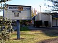
From 1912 to 1956, students went to Milpitas Grammar School, which is now the city library. More schools were built, and in 1968, all the city schools joined together to form the Milpitas Unified School District.
Here are some of the schools in the district:
- Burnett Elementary
- Calaveras Hills High School
- Curtner Elementary
- Milpitas Adult Education
- Milpitas High School
- Milpitas Middle College High School
- Mattos Elementary
- Pomeroy Elementary
- Rancho Middle School
- Randall Elementary
- Rose Elementary
- Russell Middle School
- Sinnott Elementary
- Spangler Elementary
- Weller Elementary
- Zanker Elementary
Transportation
Roads
Major roads in Milpitas include Dixon Landing Road, Jacklin Road, Calaveras Boulevard, and Landess Avenue/Montague Expressway (running east-west). Important north-south roads are Piedmont Road, Evans Road, Park Victoria Drive, Milpitas Boulevard, Main Street, Abel Street, and McCarthy Boulevard.
Milpitas has well-maintained roads. Like many California cities, pedestrians need to press a button at crosswalks to get the "walk" signal. Not all streets have bike lanes or sidewalks, but some, like Piedmont Road and Jacklin Road, have excellent ones.
Interstate 680 and Interstate 880 connect Milpitas to Fremont (north) and downtown San Jose (south). State Route 237 starts in Milpitas and goes west to Sunnyvale and Mountain View.
Public Transportation
Milpitas has a BART station, which opened in 2020. This station connects to the Santa Clara Valley Transportation Authority (VTA) light rail system. A bridge connects the BART station to the VTA light rail station.
The VTA also runs local buses in Milpitas. There are three light rail stations within the city: Milpitas, Great Mall, and Alder.
The closest major airport is the San Jose International Airport (SJC), which is less than ten minutes away.
Communications
The main post office for Milpitas is on Abel Street. The main ZIP code for Milpitas is 95035. In 2009, Milpitas launched a free public WiFi wireless network for the entire city, making it one of the first cities to offer free internet access to everyone.
Notable People
Many interesting people have connections to Milpitas, including:
- Kim Bokamper – a football player for the Miami Dolphins
- Mark Foster – lead singer of the band Foster the People
- Jeannie Mai – a TV personality
- Deltha O'Neal – an NFL football player
- Vita Vea – an NFL football player for the Tampa Bay Buccaneers
- Andy Weir – a science fiction writer, who wrote The Martian
Sister Cities
Milpitas has sister city relationships with:
 Tsukuba, Japan
 Huizhou, China
 Dagupan, Philippines
Images for kids
-
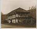
The Jose Maria Alviso Adobe, built by José María Alviso, founder of Milpitas.
-
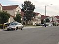
Newly built homes in the Parktown development.
-
The Milpitas Library, built in 2009, includes the 1915 Milpitas Grammar School building.
-

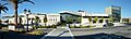
From left to right: Milpitas Community Center, Milpitas City Hall, and Milpitas Public Library.
-
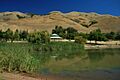
Ed R. Levin County Park.
-
Milpitas High School.

See also
 In Spanish: Milpitas (California) para niños
