
Pacheco Pass facts for kids
Quick facts for kids Pacheco Pass |
|
|---|---|

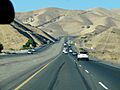
Coming over the pass eastbound on CA 152
|
|
| Elevation | 1,368 ft (417 m) |
| Traversed by | |
| Location | Santa Clara County, California, U.S. |
| Range | California Coast Ranges |
| Coordinates | 37°3′59″N 121°13′7″W / 37.06639°N 121.21861°W |

Location in California
|
|
| Reference #: | 829 |
Pacheco Pass is a mountain pass located in the Diablo Range in California. It sits in southeastern Santa Clara County, California. This pass is like a natural gateway. It connects the Santa Clara Valley with the huge Central Valley.
The pass is not super high, only about 1,368 ft (417 m) tall. It's a key route through the California Coast Ranges. The main road that goes over Pacheco Pass is State Route 152. This road stretches for 106 miles (171 km). It runs from SR 1 in Watsonville to SR 99. The part of the road called Pacheco Pass Road is two lanes wide near Gilroy. It becomes four lanes wide as it goes over the pass.
Contents
What's in a Name?
.jpg)
Pacheco Pass got its name from Don Francisco Pérez Pacheco. He was a famous ranch owner from the Californio era. His large lands, called the Rancho Ausaymas y San Felipe, were right near the pass.
In the 1850s, people sometimes called it Robber's Pass. This was because travelers using the route sometimes faced hold-ups.
A Journey Through Time
Long ago, the Yokuts people used a trail near here. This trail, now part of Pacheco State Park, helped them cross the mountains. They used it to trade with other native groups near the coast.
In 1805, a Spanish army officer named Gabriel Moraga was the first to write about the pass. After that, Spanish and Mexican soldiers used it often. They crossed into the San Joaquin Valley. Native Americans also used it in the 1820s and 1830s. They traveled west to get horses and cattle from missions and ranches.
During the California Gold Rush, Pacheco Pass became very important. People used it to travel between the Santa Clara Valley and the goldfields. However, the eastern side of the pass was very steep. It was a tough trail for horses and mules. Wheeled vehicles found it almost impossible.
In 1857, Andrew D. Firebaugh built a new wagon road. This road had a gentler slope. It made crossing the pass much easier. Since then, it has been a major route.
Pacheco Pass was also home to Pacheco Pass Station. This was a stop on the Butterfield Overland Mail stagecoach route. This route connected Saint Louis, Missouri with San Francisco. It operated from 1858 to 1861. Other stage lines used the route even after that. They continued until railroads were built in California.
Today, Pacheco Pass is recognized as California Historical Landmark #829. This means it's an important historical site.
What's Around Pacheco Pass?
There aren't any big towns right between Gilroy and Los Banos. These are the two main cities connected by the pass.
To the west of the pass, you'll find Casa de Fruta. This is a large trading post in the valley of Pacheco Creek. It started by selling local fruits and nuts to travelers. Now, Casa de Fruta has grown. It includes a deli, a truck stop, and an RV park. A small place called Bell Station is also along the route. It's between Casa de Fruta and the pass itself.
On the eastern side of the pass is the San Luis Reservoir. This huge reservoir stores water for big projects. These include the Central Valley Project and the California State Water Project. The San Luis Reservoir and O'Neill Forebay also work together. They act like a giant battery, storing energy using water.
The entrances to the San Luis Reservoir state recreational area and Pacheco State Park are near the pass. You need to be careful when entering or leaving. There are no stop signs or traffic lights. The highway has two lanes of busy traffic in each direction.
Pacheco State Park is south of the pass. You can enter it from Dinosaur Point Road. There's also a small windfarm at the top of the pass. You can see it from Dinosaur Point Road.
The Pacheco Pass American Viticultural Area is also nearby. This area is known for growing grapes for wine.
Future High-Speed Rail
Pacheco Pass has been chosen for the route of the California High-Speed Rail. This train will connect the Bay Area with the Central Valley. The plan is for the train to go under the pass. It will travel through the 13-mile Pacheco Pass Tunnel. When finished, these tunnels are expected to be the longest rail tunnels in North America!
Images for kids
-
Coming over the pass eastbound on CA 152
-
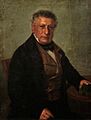
Pacheco Pass is named after Don Francisco Pérez Pacheco. He was a well-known ranch owner in California.
