Pacheco Creek (San Benito County) facts for kids
Quick facts for kids Pacheco Creek |
|
|---|---|

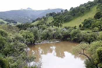
North Fork Pacheco Creek Dam just north of Highway 152, facing south, courtesy of Gary Reyes
|
|
| Other name(s) | Arroyo de San Felipe |
| Country | United States |
| State | California |
| Region | San Benito and Santa Clara Counties, |
| Physical characteristics | |
| Main source | Confluence of North Fork Pacheco Creek and South Fork Pacheco Creek Just south of Pacheco Reservoir, Santa Clara County 431 ft (131 m) 37°02′42″N 121°17′23″W / 37.04500°N 121.28972°W |
| River mouth | San Felipe Lake, the source of the Pajaro River 5 mi (8 km) east of Gilroy 144 ft (44 m) 36°58′38″N 121°27′37″W / 36.97722°N 121.46028°W |
| Basin features | |
| Tributaries |
|
Pacheco Creek is a stream about 28 miles (45 kilometers) long. It starts in the Diablo Range mountains in southeastern Santa Clara County, California. The creek flows west and southwest. It ends in San Felipe Lake, which is where the Pajaro River begins. This lake is in San Benito County, California.
History of Pacheco Creek
Pacheco Creek is named after Francisco Pacheco and Juan P. Pacheco. They received large land grants called Rancho Ausaymas y San Felipe in the 1830s and 1840s. An older name for the creek was Arroyo de San Felipe. Francisco Pacheco first came to California in 1819.
Near the dam on North Fork Pacheco Creek, there was once a safe place for the Amah-Mutsun band of the Ohlone people. This area is very important for history and archeology. Many ancient burial sites and tools have been found here. Some tools include large spear points that might have been used for hunting bears or elk.
In 1993, a researcher named Mark Hylkema found eight different Native American sites in this area. These sites show that people lived here between 1000 B.C. and 500 A.D.
Flooding Events
On January 11, 2017, a part of the creek's bank broke. This caused water to spread into about fifty local homes. Health officials later advised some people not to drink their tap water until it was checked for safety.
Pacheco Creek Watershed
A watershed is an area of land where all the water drains into a single river or lake. The main part of Pacheco Creek forms where two smaller streams meet: the North Fork Pacheco Creek and the South Fork Pacheco Creek. This meeting point is about 7 miles (11 kilometers) west of Pacheco Pass.
The creek generally follows Highway 152. It flows from Santa Clara County into San Benito County. It continues until it reaches San Felipe Lake, which is the start of the Pajaro River.
The North Fork Pacheco Creek is about 19 miles (31 kilometers) long. It begins in Henry W. Coe State Park at an elevation of about 2,360 feet (720 meters). It is joined by the East Fork Pacheco Creek before it reaches Pacheco Reservoir.
Another important stream, Mississippi Creek, flows into the North Fork Pacheco Creek. Mississippi Creek is about 9.5 miles (15.3 kilometers) long. It has a lake called Mississippi Lake high up in the mountains.
Just before Pacheco Creek joins San Felipe Lake, it is joined by Tequisquita Slough. This slough has three main branches: Santa Ana Creek, Arroyo de Los Viboras, and Arroyo Dos Pichachos. Santa Ana Creek might be named after an old land grant called Rancho Santa Ana y Quien Sabe.
The amount of water flowing in Pacheco Creek is controlled by releases from the North Fork Pacheco Reservoir. This reservoir is managed by the Pacheco Pass Water District.
Pacheco Creek Ecology
Pacheco Creek has important areas of riparian habitat. This means it has plants and trees that grow along the banks of the creek. One special tree found here is the California sycamore (Platanus racemosa). These areas are good examples of a specific type of woodland found along Central Coast rivers.
Pacheco Creek was historically home to steelhead trout (Oncorhynchus mykiss). Steelhead trout are a type of fish that can live in both fresh water and the ocean. A specimen of steelhead trout was collected from the creek in 1945.
The Pacheco Reservoir (North Fork Dam) acts as a barrier for these fish. It stops steelhead trout from swimming upstream to reach about 34.5 miles (55.5 kilometers) of other streams. These streams include North Fork Pacheco Creek, Mississippi Creek, and East Fork Pacheco Creek.
Even though the dam blocks some fish, rainbow trout (which are the same type of fish as steelhead but live only in fresh water) can still grow well in the fast-moving parts of the creek. However, in some years, during late spring, the water flow can become very low. This, along with high water temperatures, can make it hard for young steelhead and rainbow trout to survive.
Other native fish found in North Fork Pacheco Creek include the Monterey sucker (Catostomus occidentalis mniotiltus) and the Sacramento pikeminnow (Ptychocheilus grandis).
 | Jewel Prestage |
 | Ella Baker |
 | Fannie Lou Hamer |

