
North Fork Pacheco Creek facts for kids
Quick facts for kids Pacheco Creek |
|
|---|---|

Aerial Photo of North Fork Pacheco Creek Watershed in the Diablo Range of Northern California
|
|
| Country | United States |
| State | California |
| Region | Santa Clara County |
| Physical characteristics | |
| Main source | Henry Coe State Park 2,360 ft (720 m) 37°11′17″N 121°25′42″W / 37.18806°N 121.42833°W |
| River mouth | Confluence of North Fork Pacheco Creek and South Fork Pacheco Creek 16.5 mi (27 km) east of Gilroy 430 ft (130 m) 37°02′42″N 121°17′23″W / 37.04500°N 121.28972°W |
| Basin features | |
| Tributaries |
|
North Fork Pacheco Creek is a stream in Santa Clara County, California. It flows for about 19 miles (31 km). This creek is a "tributary," meaning it's a smaller stream that flows into a larger one. North Fork Pacheco Creek joins with South Fork Pacheco Creek to form Pacheco Creek. Its journey begins high up in Henry W. Coe State Park. This area is also where the Pajaro River watershed starts.
Contents
A Look Back: History of the Creek
Ancient Life Along the Creek
Long ago, people lived near North Fork Pacheco Creek. In 1993, an archeologist named Mark Hylkema found eight ancient Native American sites. These sites were on the Andresen Ranch, along the lower part of the creek. They showed that people lived there between 1000 B.C. and 500 A.D.
These sites included places where people were buried. This tells us that the area was used a lot by early communities. Another archeologist, E. Breck Parkman, studied sites further up the creek. He found that the main people living there were the Ohlone peoples. These groups included the Tomoi, Locobo, and Cobo Ohlone.
Changes for the Ohlone People
Between 1800 and 1808, the Ohlone people were moved from their homes. They were taken to Missions Santa Clara and Mission Santa Cruz. This was a big change in their way of life.
The Creek's Journey: Its Watershed
Understanding a Watershed
A "watershed" is an area of land where all the water drains into a single river or stream. The North Fork Pacheco Creek watershed collects water from many places.
Main Branches of the Creek
North Fork Pacheco Creek has two main branches, called tributaries.
- Mississippi Creek: This branch is about 9.5 miles (15 km) long. It has a lake called Mississippi Lake high up in the mountains. Mississippi Creek starts on Bear Mountain, in the northern part of Henry W. Coe State Park.
- East Fork Pacheco Creek: This branch is about 6 miles (10 km) long. It joins the North Fork Pacheco Creek near a place called Chimney Rock.
After these branches join, the creek flows towards Pacheco Reservoir and Dam. This dam is just north of Highway 152. The North Fork Pacheco Creek then meets the South Fork Pacheco Creek. This meeting point is where the main Pacheco Creek begins, west of Pacheco Pass.
Plans for the Dam
In 2019, there were plans to replace the Pacheco Creek dam. The idea was to build a much larger dam. This new dam would hold a lot more water. It would be bigger than Anderson Reservoir, which is currently the largest in Santa Clara County.
However, some groups who care about the environment had a different idea. They suggested building a smaller dam only on the East Fork Pacheco Creek. This would block only one stream instead of two. Their goal is to help fish like steelhead trout. By keeping the North Fork Pacheco Creek open, these fish could swim upstream to their natural spawning grounds in Henry Coe State Park.
Life in the Creek: Ecology
Fish and the Dam
The Pacheco Reservoir dam is a big problem for steelhead trout (Oncorhynchus mykiss). These fish need to swim upstream from the ocean to lay their eggs. The dam blocks their path. This means they can't reach about 34.5 miles (55 km) of stream habitat. This includes North Fork Pacheco Creek, Mississippi Creek, and East Fork Pacheco Creek.
However, there are "resident rainbow trout" living in the upper parts of the creek. These are like steelhead trout but they live their whole lives in fresh water. They can't swim to the ocean because of the dam. This can lead to problems like "inbreeding depression." This means the fish might become less healthy over time because they can't mix with other fish populations.
Helping the Fish Survive
Sometimes, in late spring, the water levels in the creek get very low. The water also gets too warm. This is bad for young steelhead trout. A professor named Jerry Smith from San Jose State University suggested a solution. He recommended that water should be released from the dam in April or May. This would help the young fish swim downstream safely.
Other native fish also live in North Fork Pacheco Creek. These include the Monterey sucker (Catostomus occidentalis mniotiltus) and the Sacramento pikeminnow (Ptychocheilus grandis).
Images for kids
-
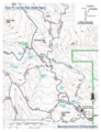
Map of southeastern Henry Coe State Park in the Diablo Range of California, showing North Fork Pacheco Creek and the "Hole in the Rock" barrier to upstream steelhead trout runs below the Brem Horse Camp

