
Pajaro River facts for kids
Quick facts for kids Pajaro River |
|
|---|---|

Aerial view of the Pajaro River at Watsonville, California. The river empties into the Pacific Ocean about 2.5 miles (4 km) west of this photograph. View is to the east.
|
|
| Other name(s) | Río de San Antonio, Río del Pájaro |
| Country | United States |
| State | California |
| Region | Santa Cruz, Monterey, Santa Clara, and San Benito counties |
| Physical characteristics | |
| Main source | San Felipe Lake 7 mi (11 km) east of Gilroy 146 ft (45 m) 36°58′55″N 121°29′18″W / 36.98194°N 121.48833°W |
| River mouth | Monterey Bay 5 mi (8 km) southwest of Watsonville 0 ft (0 m) 36°51′00″N 121°48′35″W / 36.85000°N 121.80972°W |
| Length | 30 mi (48 km) |
| Basin features | |
| Basin size | 1,300 sq mi (3,400 km2) |
| Tributaries |
|
The Pajaro River is a river in the Central Coast area of California, in the United States. Its name comes from the Spanish word pájaro, which means bird. This river forms part of the border between several counties: San Benito and Santa Clara, all of San Benito and Santa Cruz, and all of Santa Cruz and Monterey. The Pajaro River flows from east to west and eventually empties into Monterey Bay, near the city of Watsonville, California.
Contents
History of the Pajaro River
The first Europeans to explore this part of California were from Spain. The Portolá expedition camped near the river on October 8–9, 1769. This was close to where the town of Pajaro is today. The soldiers called the river "Pajaro" because they saw local people with a large stuffed bird. A missionary named Juan Crespi, who was with the group, wrote in his diary that some thought it looked like a royal eagle, possibly an osprey.
The Pajaro River has had many names over time. Early Spanish maps called it Rio de San Antonio or Rio del Pajaro. Other names included Pigeon River and San Antonio River.
In 1953, experts found that the Pajaro Valley area had a problem with its underground water. Too much water was being pumped out, causing saltwater intrusion. This means ocean water was seeping into the freshwater supply. By the 21st century, a large area of underground water was affected, making it risky for drinking and farming.
The Pajaro River is also known for its history of flooding. The towns of Pajaro and Watsonville were built on the river's natural floodplain. Before engineers built protective walls called levees, floods often caused great damage to homes, businesses, and farms.
Levees were built in 1949 to help control the floods. However, even after they were built, there have been many floods due to bad weather or problems with the levees themselves. After big floods in 1995, some people sued the local counties and the California Department of Transportation. They said these groups had not kept the levees in good condition, as they had promised in 1944.
Timeline of Major Floods
| Date | Flooding impacts |
|---|---|
| 1890 | A severe flood happened when a rail bridge blocked the river's flow to the ocean. This caused the biggest floods known for the next 50 years. |
| 1894 | Flooding occurred near the city of Watsonville, California. |
| 1907 | Major flooding happened across the whole region. |
| 1911 | The river overflowed near the city of Watsonville each year. |
| 1914 | |
| 1915 | |
| 1916 | |
| 1922 | |
| 1927 | |
| 1931 | |
| 1933 | |
| 1937 | |
| 1938 | Flooding occurred. |
| 1949 | (Army Corps of Engineers built levees) |
| 1955 | Flooding occurred. |
| 1963 | The river overflowed near the city of Watsonville. |
| 1982 | Farmland flooded near Llagas Creek. Water also flooded parts of Watsonville and nearby farms. |
| 1983 | Farmland flooded where the Pajaro River and Carnadero Creek meet. |
| 1986 | Significant flooding on the Pajaro River in February. |
| 1995 | Homes and businesses were damaged, and 2,500 people had to leave their homes. Damage to farms was about $67 million, and city damage was about $28 million. Two people drowned. |
| 1997 | Flooding occurred. |
| 1998 | The town of Pajaro was evacuated. The river's protective walls (levees) broke in several places. |
Geology of the Pajaro River Area
The San Andreas Fault line, a major crack in the Earth's crust, crosses the Pajaro River near Aromas, California. The land on one side of the fault, called the Salinian Block, is slowly moving north. This block is made of granite and old ocean sediments.
Because of the San Andreas Fault, the Pajaro River has changed its path many times. In the past, it flowed into the Elkhorn Slough before reaching the Pacific Ocean. Today, it joins Corralitos Creek and flows into the ocean a bit further north.
The 1989 Loma Prieta earthquake in the Santa Cruz Mountains also damaged the river's levee system. Other fault lines in the area include the Zayante, Sargent, and Calaveras faults.
Geography of the Pajaro River
The unique landscape of the Pajaro River area is shaped by its geology. The river starts in the Diablo Range to the east. From the south, another smaller river flows from the Gabilan Mountains. From the north, streams flow from the Santa Cruz Mountains to join the Pajaro River.
Climate Around the River
The region has a Mediterranean climate. This means it has warm, dry summers and mild, wet winters. In Watsonville, summer temperatures reach about 68°F (20°C), and winter lows are around 47°F (8°C). The area gets about 23.5 inches (60 cm) of rain each year, mostly in winter. Some smaller streams that feed the river often dry up in the summer due to lack of rain.
The Pajaro River Watershed
A watershed is an area of land where all the water drains into a single river or body of water. The Pajaro River watershed is very large, covering about 1,300 square miles (3,400 km2). It includes parts of Santa Cruz, Santa Clara, San Benito, and Monterey Counties.
The main part of the Pajaro River begins west of San Felipe Lake. This lake is a natural lake formed where Pacheco Creek and other streams meet. Pacheco Creek starts high up in the Diablo Range. The Pajaro River then flows west for about 30 miles (50 km), past Watsonville, and into Monterey Bay.
San Felipe Lake is a special type of lake called a sag pond. It was formed by the Calaveras Fault, which created a natural wall along its western side. The San Andreas Fault also runs through the watershed, changing how water has flowed over time.
The San Benito River is the largest stream that flows into the Pajaro River. It is even longer than the Pajaro itself! It flows for about 65 miles (105 km) from San Benito Mountain before joining the Pajaro River.
In the lower part of the watershed, near the ocean, the river mouth is often open to the tides. If too much sand builds up, it sometimes needs to be dug out to prevent nearby farms from flooding.
Most of the drinking water and water for farms in this area comes from underground water sources called aquifers. However, these aquifers are facing problems. Too much water is being pumped out, leading to seawater intrusion, where ocean water mixes with the freshwater. Also, some aquifers are polluted by runoff from farms.
Ecology and Wildlife
In 2006, the Pajaro River was named America's most endangered river by an organization called American Rivers. This was because of the levees built along its lower 22 miles (35 km) and the pollution from farms.
Many native California fish live in the lower Pajaro River. These include the three-spined stickleback, Sacramento perch, riffle sculpin, Russian River tule perch, steelhead trout, and thicktail chub.
Several animals living in or near the Pajaro River are considered threatened or endangered. These include:
- Steelhead trout
- California red-legged frog
- Northern tidewater goby
- Snowy plover, which nests at the river mouth.
Other important species that live near the river include:
- Western pond turtles
- Pallid bat
- Burrowing owls
- Dusky-footed woodrat
- Least Bell's vireo
- Yellow-breasted chat
San Felipe Lake is a very important place for birds. It's called a "California Important Bird Area" by the National Audubon Society. Many birds migrating between San Francisco Bay, Monterey Bay, and the Central Valley pass through here. It's also a place where rare birds, far from their usual homes, sometimes appear.
The Pajaro River is a pathway for adult steelhead trout to swim upstream to lay their eggs and for young fish to grow. However, the main river itself isn't great for this because of low water in summer and too much dirt in the water.
Historically, large fish like white sturgeon and Chinook salmon were found in the Pajaro River. There's also a record of North American river otters living in a stream that feeds into the Pajaro River.
Water Quality Concerns
The Pajaro River faces serious pollution problems. People sometimes dump trash illegally into the river. For example, in one cleanup in 2015, over 1,000 tires, five boats, two trucks, and tons of garbage were removed.
The river also has high levels of toxic chemicals from farming. Pesticides have been found in the water, especially after heavy rains. These chemicals can be harmful to the fish and other aquatic animals living in the river.
Improvements and Future Plans
There are many efforts underway to improve the Pajaro River and its surrounding areas.
- In 2010, the City of Watsonville received money to create a public access point for canoes and kayaks. This project included a parking lot, a trail, and public restrooms.
- The Pajaro River CARE project is working to help the river, funded by the California Natural Resources Agency.
- Several water agencies are working together on the Pajaro River Watershed Integrated Regional Water Management Plan. Their goal is to manage and improve the entire watershed.
- The Pajaro River Bench Excavation Project, approved in 2012, will remove extra dirt and plants from the riverbed. This will help the water flow better through the levees and improve flood protection.
- California has given $7.6 million to the Pajaro watershed for water projects. One project built large storage tanks for a water recycling plant, which provides water for local farms.
- In 2015, land in the upper Pajaro Watershed was bought to protect farms, increase flood protection, and help wildlife. This land will remain undeveloped, which helps reduce flooding downstream and creates safe pathways for animals.
Images for kids
-
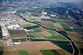
Aerial view of the Pajaro River at Watsonville, California.
-
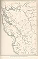
Monterey Bay is south of the San Francisco Bay.
-
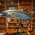
Last Chinook salmon caught in the Pajaro River watershed, at Uvas Creek near the intersection of Burchell and Watsonville Roads, west of Gilroy, California. The 40 lb. salmon was landed by Herman Garcia, Sr. in 1953.
-
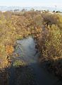
Pajaro riparian area


See also
 In Spanish: Río del Pájaro para niños
