Pajaro, California facts for kids
Quick facts for kids
Pajaro, California
|
|
|---|---|

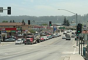
Pajaro, viewed from the bridge across the Pajaro River
|
|

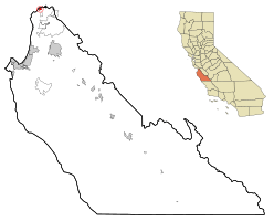
Location in Monterey County and the state of California
|
|
| Country | United States |
| State | California |
| County | Monterey |
| Area | |
| • Total | 0.929 sq mi (2.41 km2) |
| • Land | 0.929 sq mi (2.41 km2) |
| • Water | 0 sq mi (0 km2) |
| Elevation | 26 ft (8 m) |
| Population
(2020)
|
|
| • Total | 2,882 |
| • Density | 3,102.3/sq mi (1,197.8/km2) |
| Time zone | UTC-8 (Pacific) |
| • Summer (DST) | UTC-7 (PDT) |
| ZIP code |
95076
|
| Area code | 831 |
| FIPS code | 06-55044 |
| GNIS feature IDs | 1659773 |
Pajaro (pronounced PAH-hah-roh) is a small community in Monterey County, California. Its name comes from the Spanish word Pájaro, which means 'bird'. It is an unincorporated community, meaning it's not officially a city with its own local government. Instead, it's part of the wider county area. It is also a census-designated place (CDP), which is a special area the government uses for counting people.
Pajaro is located on the south bank of the Pajaro River, about 5 miles (8 km) northeast of where the river meets the ocean. It sits at an elevation of 26 feet (8 meters) above sea level. In 2020, the population was 2,882 people. This was a slight decrease from 3,070 people in 2010. Interestingly, even though Pajaro is in Monterey County, the local school district is in Santa Cruz County, which is right next door.
Contents
Exploring Pajaro's Geography
Pajaro is located in the beautiful Pajaro Valley. The Pajaro River forms the northern border of the community. This river also marks the boundary between Monterey County and Santa Cruz County. Just across the river to the northwest is the city of Watsonville, which is in Santa Cruz County.
The United States Census Bureau reports that the Pajaro CDP covers a total area of 0.9 square miles (2.3 square kilometers). All of this area is land, with no significant water bodies within its boundaries.
Pajaro's Past: A Look at Its History
The Pajaro community has a history that goes back many years. A post office operated here for short periods, first from 1872 to 1873, and then again from 1882 to 1888.
The oldest building in Pajaro is the Porter-Vallejo Mansion. It was built in the 1840s and has been changed and updated many times over the years. In 1991, this historic building was bought and turned into a public library and a center for senior citizens. It also has a day-care facility for the children of people who work as migrant farm workers in the area. In 1984, a local leader named Marc Del Piero helped get money to completely rebuild the public water system. This system was then given to the new Pajaro Community Services District.
A notable event in Pajaro's history happened on May 11, 1903. Theodore Roosevelt, who was the President of the United States at the time, made a brief stop in Pajaro. He gave a ten-minute speech from his special train as part of a "whistle-stop tour" on his way to Santa Cruz. He arrived at 8:50 AM and left at 9:00 AM.
Unfortunately, Pajaro has experienced severe flooding several times. Major floods occurred in 1995, 1998, and most recently in 2023.
Getting Around: Transportation in Pajaro
There are plans to build a new train station called Pajaro/Watsonville station at Watsonville Junction. This station would serve two important train lines: Caltrain and Amtrak's Capitol Corridor. This would make it easier for people in Pajaro to travel to other parts of California by train.
Understanding Pajaro's Population
The population of Pajaro has changed over the years. Here's a look at some details from past censuses:
Population in 2010
The 2010 United States Census counted 3,070 people living in Pajaro. This meant there were about 3,312 people per square mile.
Most of the people in Pajaro identified as Hispanic or Latino, making up 94.1% of the population. Other groups included White (47.3%), Native American (2.5%), and Asian (1.7%).
The census showed that 97% of the population lived in regular homes. There were 621 households in total. Many of these households (71.5%) had children under 18 living in them. The average household had about 4.80 people.
The population was quite young, with 34.8% of residents being under the age of 18. The median age was 25.6 years old. This means half the population was younger than 25.6, and half was older.
There were 655 housing units in Pajaro. About 22.7% of these homes were owned by the people living in them, while 77.3% were rented.
Population in 2000
In the census of 2000, Pajaro had 3,384 people. The population density was about 3,614 people per square mile.
Similar to 2010, a large majority of the population (94.24%) identified as Hispanic or Latino.
There were 634 households, and 66.9% of them had children under 18. The average household size was 5.28 people.
The population was also very young in 2000, with 39.6% of residents under the age of 18. The median age was 23 years.
Community Services and Infrastructure
Public services in Pajaro are partly managed by the Pajaro-Sunny Mesa Community Services District (PSMCSD). This organization was created in 1984. PSMCSD is a non-profit government agency that provides important services to the community. These include public water services, public sewer services, park services, and street lighting.
PSMCSD has also grown to provide water services to nearby communities like Prunedale, Elkhorn, and Moss Landing in North Monterey County. Between 1984 and 1990, federal money was secured to rebuild and expand parts of the sewer system. This helped solve public health issues and brought services to more neighborhoods, including Bay Farms, Fruitland, and Las Lomas.
See also
 In Spanish: Pájaro (California) para niños
 | Janet Taylor Pickett |
 | Synthia Saint James |
 | Howardena Pindell |
 | Faith Ringgold |


