
San Benito River facts for kids
Quick facts for kids San Benito River |
|
|---|---|

The San Benito River valley and Hernandez Reservoir
|
|

Mouth of San Benito River
|
|
| Other name(s) | San Juan River |
| Country | United States |
| State | California |
| Region | San Benito County |
| Physical characteristics | |
| Main source | southeast of Santa Rita Peak in the Diablo Range. 4,760 ft (1,450 m) 36°19′58″N 120°35′03″W / 36.33278°N 120.58417°W |
| River mouth | mouth at its confluence with the Pajaro River. 115 ft (35 m) 36°53′47″N 121°33′46″W / 36.89639°N 121.56278°W |
| Length | 109 mi (175 km) |
The San Benito River is a long river in California. It flows for about 109 miles (175 km). This river runs through the Central Coast of California. It flows between two mountain ranges: the Diablo Range and the Gabilan Range.
The San Benito River starts in the southeastern part of San Benito County, California. It then flows northwesterly. The river ends in the northwestern part of the same county. Here, it joins the Pajaro River. The San Benito River is actually longer than the Pajaro River. It also drains a larger area of land.
Contents
History of the San Benito River
How did the San Benito River get its name? In 1772, a priest named Father Juan Crespí explored this area. He named the river to honor San Benito. This is the Spanish name for Saint Benedict. Saint Benedict is known as the patron saint of monks.
Where Does the River Flow?
The San Benito River collects water from a large area. This area is called its watershed. The watershed covers about 530 square miles (1,373 square kilometers). Tres Pinos Creek is the main stream that flows into the San Benito River.
The river starts high up in the mountains. Its source is about 4,760 feet (1,451 meters) high. This is southeast of Santa Rita Peak in the Diablo Range. From there, the river flows to Hernandez Reservoir. This reservoir is a lake formed by a dam. The dam was built in the early 1960s. It helps store water for farms and controls floods. The lake can hold a lot of water, about 18,000 acre-feet.
Below the dam, the riverbed is often dry in summer. This is because the Central Coast gets most of its rain in winter. As the river continues its journey, it passes through small towns. These include San Benito, Paicines, and Tres Pinos. Eventually, it reaches Hollister, California. Here, the river turns west into the San Juan Valley. It then flows north to meet the Pajaro River. This meeting point is about 15 miles (24 km) upstream from where the Pajaro River flows into Monterey Bay.
River Rocks and Minerals
The soil around the San Benito River is special. It comes from a type of rock called serpentine. This rock naturally contains asbestos. People have mined materials like asbestos, sand, gravel, and gypsum here. This mining has changed the river's environment.
Did you know California has an official state gem? It's called Benitoite. This special gem was first found near where the San Benito River begins. The gem is named after its home, San Benito County. Sometimes, you can even find old fossils in parts of the river!
Wildlife in the River
For many years, certain fish were missing from the San Benito River. But thanks to a group called CHEER, led by Herman Garcia, things are changing! They worked to clean up the river near its mouth. After their efforts, young steelhead trout (Oncorhynchus mykiss) returned! This means the river now has good places for these fish to lay eggs and grow. It had been about 75 years since they were last seen there.
Back in 1940, the California Department of Fish and Wildlife (CDFW) said the San Benito Creek was a "good trout stream" near its source. They also noted that "sea-run steelhead" would swim up the river in some years. However, by 1962, the CDFW reported a change. They said the small number of steelhead in the San Benito River had mostly disappeared. This happened after the Hernandez Project dam was built.
Images for kids
-
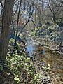
Looking upstream from the mouth of the 109-mile long San Benito River.
-
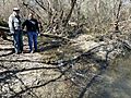
Two individuals stand at the mouth of the San Benito River, where it flows in the Pajaro River.

_%26_Herman_Garcia_(R)_at_the_San_Benito_River%27s_confluence_with_the_Pajaro_River_2022-03-07.jpg)
