
Tres Pinos, California facts for kids
Quick facts for kids
Tres Pinos
|
|
|---|---|

Tres Pinos Post Office
|
|

Location of Tres Pinos in San Benito County, California
|
|

Tres Pinos, California
Location in California
|
|
| Country | United States |
| State | California |
| County | San Benito |
| Area | |
| • Total | 3.597 sq mi (9.316 km2) |
| • Land | 3.597 sq mi (9.316 km2) |
| • Water | 0 sq mi (0 km2) 0% |
| Elevation | 531 ft (162 m) |
| Population
(2020)
|
|
| • Total | 443 |
| • Density | 123.16/sq mi (47.55/km2) |
| Time zone | UTC-8 (Pacific (PST)) |
| • Summer (DST) | UTC-7 (PDT) |
| ZIP Code |
95075
|
| Area code(s) | 831 |
| GNIS feature IDs | 1660025; 2583166 |
Tres Pinos is a small community in San Benito County, California. Its name means "Three Pines" in Spanish. This area is known as a census-designated place, which means it's a community that is counted in the census but isn't officially a city.
Tres Pinos is located along State Route 25. It's about 4 miles south of Hollister and 5 miles north of Paicines. The community sits at an elevation of about 531 feet (162 meters) above sea level. In 2020, about 443 people lived in Tres Pinos.
Contents
Life in Tres Pinos
Tres Pinos uses the (831) area code for phone numbers. The local phone numbers start with 628.
The Zip Code for Tres Pinos is 95075. People living here get their mail from post office boxes. There is no mail delivery directly to homes.
Education in Tres Pinos
Kids in Tres Pinos attend Tres Pinos Elementary School. This school teaches students from kindergarten all the way through 8th grade. The Tres Pinos Union Elementary School District manages the school. A group of five elected people called the Board of Trustees oversees the district.
Community Services
The Tres Pinos County Water District provides water and wastewater treatment services. This district is managed by an elected group of five people called the Board of Directors.
For medical care, the Hazel Hawkins Memorial Hospital is nearby. It is located in Hollister, which is less than five miles (about 8 kilometers) north of Tres Pinos.
History of Tres Pinos
The town of Tres Pinos has an interesting history. It wasn't always in the same spot!
Changing Locations
Originally, the town of Tres Pinos was located about 5 miles south of a town called Paicines. But that changed because of the railroad. The Southern Pacific Railroad was building a train line. By 1873, the railroad reached Paicines. Trains ran twice a day for passengers and twice a day for cargo.
To make it seem like the railroad went further, the names of the two towns were switched in 1874. So, the place that was once Paicines became Tres Pinos, and the original Tres Pinos became Paicines. This allowed the railroad to say they built a line all the way to "Tres Pinos."
A Busy Hub
In its busiest times, Tres Pinos was a very important place. It was the end of the railroad line, which meant goods and people arrived and departed from here. It was also a stop for stagecoaches, which were like old-fashioned buses.
The town had a Southern Pacific Hotel, where travelers could stay. There were also rodeo grounds for events, large barns for storing grain, and corrals for animals. Many saloons and restaurants were also part of the lively town.
The Tres Pinos Tragedy
In 1873, a famous event known as the "Tres Pinos Tragedy" happened. This was a robbery involving eight outlaws. Sadly, the robbery went wrong, and three people were killed during the event.
Geography of Tres Pinos
Tres Pinos covers an area of about 3.6 square miles (9.3 square kilometers). All of this area is land, meaning there are no large bodies of water like lakes or rivers within its boundaries.
Community Demographics
The 2010 United States Census showed that 476 people lived in Tres Pinos. This means there were about 132 people per square mile (51 people per square kilometer).
Most of the people in Tres Pinos were White (81.9%). There were also smaller numbers of African American, Native American, and Asian residents. About 23.5% of the population identified as Hispanic or Latino.
All 476 people lived in homes, not in group living situations. There were 166 households in total. About 37.3% of these households had children under 18 living in them. Most households (64.5%) were married couples.
The population included people of all ages. About 24.2% were under 18 years old. The median age was 44.5 years, meaning half the population was older than 44.5 and half was younger.
Most homes in Tres Pinos (76.5%) were owned by the people living in them. The rest (23.5%) were rented.
Bolado Park Fairgrounds
Bolado Park is a special place located in Tres Pinos. It is home to two big annual events: the San Benito County Fair and the San Benito County Saddle Horse Show & Rodeo. These events bring many people to the area.
Bolado Park also has a golf course, which is managed by a company that rents the space. The entire park and the fair are run by an organization called the 33rd District Agricultural Association. This association is overseen by a board of seven directors. The governor appoints these directors.
Images for kids
-
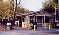
Tres Pinos Post Office
-
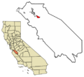
Location of Tres Pinos in San Benito County, California
See also
 In Spanish: Tres Pinos (California) para niños
