Llagas Creek facts for kids
Quick facts for kids Llagas Creek |
|
|---|---|

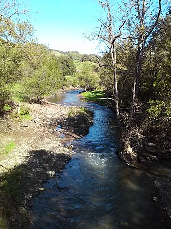
Llagas Creek near Oak Glen Avenue, March 2017
|
|
| Country | United States |
| State | California |
| Region | Santa Clara County |
| City | Gilroy, California |
| Physical characteristics | |
| Main source | On the eastern flank of Crystal Peak in the Santa Cruz Mountains 3,360 ft (1,020 m) 37°06′59″N 121°50′02″W / 37.11639°N 121.83389°W |
| River mouth | Confluence with Pajaro River just after passing through Lower Miller Slough 141 ft (43 m) 36°57′50″N 121°30′28″W / 36.96389°N 121.50778°W |
| Basin features | |
| Tributaries |
|
Llagas Creek is a stream in Santa Clara County, California, United States. It's known as a perennial stream, which means it flows all year round, even during dry seasons. This creek is an important natural feature in the area, providing water and supporting local wildlife.
Contents
About Llagas Creek
Llagas Creek starts high up on the eastern side of Crystal Peak. This mountain is part of the Santa Cruz Mountains. The creek begins near a place called Loma Prieta.
Where Llagas Creek Flows
From its starting point, Llagas Creek first flows towards the northeast. It follows along Casa Loma Road for a bit. Then, it turns south when it reaches Uvas Road.
As it continues its journey, the creek turns southeast near Oak Glen Avenue. It flows through Chesbro Reservoir, which is a lake that holds water. The creek then passes through several cities. These cities include Morgan Hill, San Martin, and Gilroy.
The Creek's Journey to the River
Llagas Creek keeps flowing south after passing through Gilroy. Eventually, it joins with the Pajaro River. This meeting point is close to the border of San Benito County.
How Llagas Creek Helps the Environment
The lower part of Llagas Creek, which is south of Gilroy, plays a special role. It flows through a system of ponds called percolation ponds. These ponds are part of a system known as Lower Miller Slough.
Cleaning Water with Nature
These percolation ponds are used to help clean wastewater. Wastewater is water that has been used and needs to be treated before it goes back into the environment. The ponds allow the water to slowly soak into the ground. This natural process helps to filter and clean the water. It's an important way to protect the environment in the area.
 | Mary Eliza Mahoney |
 | Susie King Taylor |
 | Ida Gray |
 | Eliza Ann Grier |

