
San Luis Reservoir facts for kids
Quick facts for kids San Luis Reservoir |
|
|---|---|
 |
|

San Luis Reservoir
Location in California

San Luis Reservoir
Location in the United States
|
|
| Location | Merced County, California |
| Coordinates | 37°04′04″N 121°04′52″W / 37.0679°N 121.081°W |
| Type | Reservoir |
| Primary inflows | San Luis Creek, Cottonwood Creek |
| Primary outflows | California Aqueduct |
| Catchment area | 84.6 sq mi (219 km2) |
| Basin countries | United States |
| Surface area | 12,700 acres (5,100 ha) |
| Water volume | 2,041,000 acre-feet (2,518,000 dam3) |
| Surface elevation | 544 ft (166 m) |
The San Luis Reservoir is a large artificial lake in Merced County, California. It sits on the eastern side of the Diablo Range mountains. You can find it about 12 mi (19 km) west of Los Banos. State Route 152 runs along its northern edge.
This reservoir is the fifth largest in all of California. It holds water that comes from the San Joaquin-Sacramento River Delta. Water is pumped uphill into the reservoir from a smaller area called the O'Neill Forebay. This forebay gets its water from the California Aqueduct. When needed, water is released back into the forebay. From there, it continues down the aqueduct for things like watering farms.
The reservoir is about nine miles long from north to south. It is also about five miles (8 km) wide. On the eastern side is the San Luis Dam, also known as the B.F. Sisk Dam. This dam is the fourth largest embankment dam in the United States. It helps the reservoir hold a huge amount of water. Pacheco State Park is located along the western shores of the reservoir.
Contents
Building the San Luis Reservoir
The San Luis Reservoir was finished in 1967. It was built on land that used to be part of Rancho San Luis Gonzaga. This 12,700 acres (5,100 ha) reservoir is used by two big water projects. It is part of both the California State Water Project and the federal Central Valley Project. These projects work together to move water across California. They use a huge network of reservoirs, dams, and canals.
The reservoir has a visitor center at the Romero Outlook. Here, you can learn more about the dam and the reservoir. The surface of the reservoir is about 544 ft (166 m) above sea level. The O'Neill Forebay, which is below the dam, is at 225 ft (69 m) above sea level. This height difference is important. It allows for a hydroelectric power plant to be built.
Gianelli Hydroelectric Plant
The Gianelli Hydroelectric Plant uses the water's movement to create electricity. This power is sent to a substation in Los Banos. Large power lines carry this electricity. These lines cross the O'Neill Forebay on man-made islands. They carry power from this plant and other places.
Water for Santa Clara Valley
The San Luis Reservoir also provides water to 63,500 acres (25,700 ha) of land. This land is in the Santa Clara Valley, west of the Coast Ranges. Water is sent from the San Luis Reservoir through tunnels and conduits. This water goes to the San Justo Dam. From there, it travels to the Coyote Pumping Station in the Santa Clara Valley.
Fun Activities at San Luis Reservoir
The San Luis Reservoir is part of the larger San Luis Reservoir State Recreation Area. This area is managed by California State Parks. It offers many fun things to do for visitors. You can go fishing, boating, and camping here. California State Park Peace Officers patrol the park. They use vehicles, boats, and off-highway vehicles.
Besides camping and boating, there are picnic areas at San Luis Creek. There is also a special area for off-highway vehicles (OHV). This area is east of the main park.
Camping Options
There are four different campgrounds where you can stay:
- The Basalt Campground is on the south-eastern side of the lake. It has 79 family campsites. Water is available, and some sites can fit RVs up to 40 feet (12 m) long.
- San Luis Creek Campground is on O'Neill Forebay. It has 53 sites with water and electric hook-ups.
- Medeiros Campground offers simpler campsites along the southern shore of O'Neill Forebay. It has drinking water in three spots and chemical toilets.
- Los Banos Creek Campground also has simpler campsites. It has limited space for turning around, so it's not good for trailers or motor homes. Drinking water and chemical toilets are available here too.
Boating and Fishing
You can launch your boat at Dinosaur Point and the Basalt area. The water in San Luis Reservoir comes from the Sacramento River Delta. Because of this, many of the same fish species live here. You can find largemouth bass, striped bass, crappie, bluegill, shad, and yellow perch. Sometimes, you might even catch a sturgeon or salmon.
The California Office of Environmental Health Hazard Assessment (OEHHA) gives advice on eating fish from the San Luis Reservoir. This is based on levels of mercury or PCBs found in the fish. The lake is also known for its strong winds. There are wind warning lights at Romero Outlook, Basalt Campground, and Quien Sabe Point to let people know when it's too windy.
Weather at the Reservoir
A weather station has been keeping records at San Luis Dam since 1963. These records help us understand the climate.
Temperatures
In January, the average high temperature is about 54.3 °F (12.4 °C). The average low is about 37.9 °F (3.3 °C). In July, the average high is around 92 °F (33 °C). The average low is about 64.0 °F. Each year, there are about 69 days when the temperature reaches 90 °F (32 °C) or higher. There are also about 14 days when it drops to 32 °F (0 °C) or lower.
The highest temperature ever recorded was 110 °F (43 °C) on July 24, 2006. The lowest temperature was 14 °F (−10 °C) on December 22, 1990.
Rain and Snow
On average, the area gets about 10.36 in (263 mm) of rain each year. There are about 57 days a year when it rains enough to measure. The wettest year was 1998, with 25.06 in (637 mm) of rain. The driest year was 1989, with only 4.88 in (124 mm). The most rain in one month was 9.03 in (229 mm) in February 1998. The most rain in 24 hours was 3.70 in (94 mm) on May 6, 1998. Snow does not fall often at the reservoir. However, 1.2 in (30 mm) of snow fell on January 9, 2001.
Images for kids
-
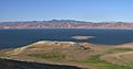
The reservoir in 2002
-
Humans at the reservoir's beaches in July 2021
-
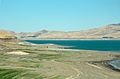
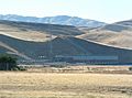
San Luis Dam
-
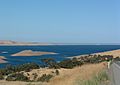
San Luis Reservoir from Romero Outlook
-
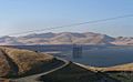
San Luis Dam and Gianelli Powerhouse
-
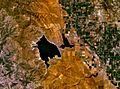
Satellite photo of San Luis Dam and the O'Neill Forebay
-
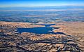
The San Luis Reservoir and O'Neill Forebay, aerial view from near Hollister, California, with late afternoon shadows outlining the hills of the oak woodlands around it.


