
Los Banos, California facts for kids
Quick facts for kids
Los Banos, California
Los Baños
|
|
|---|---|
| City of Los Banos | |
.jpg)
Aerial view of Los Banos
|
|

Location in Merced County and California
|
|

Los Banos, California
Location in California

Los Banos, California
Location in the United States
|
|
| Country | United States |
| State | California |
| County | Merced |
| Incorporated | May 8, 1907 |
| Area | |
| • Total | 10.12 sq mi (26.2 km2) |
| • Land | 10.00 sq mi (25.9 km2) |
| • Water | 0.12 sq mi (0.3 km2) 1.22% |
| Elevation | 118 ft (35 m) |
| Population
(2020)
|
|
| • Total | 45,532 |
| • Density | 4,499.2/sq mi (1,737.2/km2) |
| Time zone | UTC−8 (Pacific) |
| • Summer (DST) | UTC−7 (PDT) |
| ZIP Code |
93635
|
| Area code | 209 |
| FIPS code | 06-44028 |
| GNIS feature IDs | 277547, 2410878 |

Los Banos is a city located in Merced County, California, in the United States. It's found in the San Joaquin Valley in Central California. The city is close to where two major roads, State Route 152 and Interstate 5, meet.
In 2020, about 45,532 people lived in Los Banos. This was a jump from 35,972 people in 2010. The city also has its own airport, the Los Banos Municipal Airport, for air travel.
Contents
What's in a Name?
The name Los Baños comes from the Spanish words for "the baths." The city was named after a natural spring that feeds the wetlands in the western San Joaquín Valley.
Even though the Spanish name has a special mark called a tilde (ñ), the official spelling for the city's post office leaves it out. However, you might still see "Los Baños" on some signs around town.
Where is Los Banos?
Los Banos is on the west side of the San Joaquin Valley. It's about 26 miles (42 km) southwest of Merced. The city sits at an elevation of about 118 feet (35 meters) above sea level.
You can find Los Banos where California State Route 152 and California State Route 165 cross. Just 7 miles (11 km) to the west is Interstate 5, a big highway that runs all the way from Canada to Mexico. The San Luis Reservoir and the Diablo Range mountains are also nearby to the west.
The city covers a total area of about 10.1 square miles (26.2 square kilometers). A small part of this area, about 0.1 square miles (0.3 square kilometers), is covered by water.

Los Banos is located near many national and state wildlife refuges. These special areas are wetlands that provide homes for waterfowl (like ducks and geese) and other animals. The San Joaquin River flows through these areas, helping to keep the habitats healthy.
The San Luis National Wildlife Refuge Complex is one of these important places. It includes different units like the Kesterson Unit and East Bear Creek. Other nearby refuges are the Merced National Wildlife Refuge and the San Joaquin River National Wildlife Refuge. People who enjoy fishing, hunting, or watching birds often visit Los Banos throughout the year.
Los Banos Weather
Los Banos has a semiarid climate, which means it has cool winters and very hot summers. Most of the rain falls during the winter months. It can also get quite windy in the late afternoons, especially near Pacheco Pass.
On average, the temperature reaches 90°F (32°C) or higher for about 97 days each year. The temperature drops to 32°F (0°C) or lower about 15 days a year. The hottest temperature ever recorded was 116°F (47°C) in July 1931. The coldest was 14°F (-10°C) in January 1949 and December 1990.
The city gets about 9.48 inches (24.1 cm) of rain each year, with rain falling on about 47 days. While snow is very rare, it did snow 3 inches (7.6 cm) in January 1916 and 1.5 inches (3.8 cm) in January 1962.
| Climate data for Los Banos, California (1991–2020 normals, extremes 1929–present) | |||||||||||||
|---|---|---|---|---|---|---|---|---|---|---|---|---|---|
| Month | Jan | Feb | Mar | Apr | May | Jun | Jul | Aug | Sep | Oct | Nov | Dec | Year |
| Record high °F (°C) | 75 (24) |
80 (27) |
89 (32) |
98 (37) |
106 (41) |
114 (46) |
116 (47) |
114 (46) |
113 (45) |
104 (40) |
87 (31) |
75 (24) |
116 (47) |
| Mean maximum °F (°C) | 66.6 (19.2) |
72.4 (22.4) |
80.6 (27.0) |
89.5 (31.9) |
97.5 (36.4) |
103.6 (39.8) |
105.5 (40.8) |
104.6 (40.3) |
101.9 (38.8) |
93.1 (33.9) |
78.9 (26.1) |
66.4 (19.1) |
107.0 (41.7) |
| Mean daily maximum °F (°C) | 55.6 (13.1) |
61.7 (16.5) |
67.7 (19.8) |
73.3 (22.9) |
81.2 (27.3) |
88.9 (31.6) |
94.6 (34.8) |
93.9 (34.4) |
89.6 (32.0) |
79.2 (26.2) |
65.5 (18.6) |
55.8 (13.2) |
75.6 (24.2) |
| Daily mean °F (°C) | 47.0 (8.3) |
52.4 (11.3) |
57.1 (13.9) |
61.5 (16.4) |
68.6 (20.3) |
74.5 (23.6) |
79.3 (26.3) |
78.1 (25.6) |
74.4 (23.6) |
66.0 (18.9) |
54.8 (12.7) |
46.7 (8.2) |
63.4 (17.4) |
| Mean daily minimum °F (°C) | 39.3 (4.1) |
42.5 (5.8) |
46.1 (7.8) |
49.4 (9.7) |
55.2 (12.9) |
60.4 (15.8) |
63.8 (17.7) |
62.8 (17.1) |
60.1 (15.6) |
52.7 (11.5) |
44.3 (6.8) |
38.4 (3.6) |
51.3 (10.7) |
| Mean minimum °F (°C) | 29.1 (−1.6) |
32.6 (0.3) |
36.8 (2.7) |
38.9 (3.8) |
45.6 (7.6) |
50.4 (10.2) |
54.0 (12.2) |
54.0 (12.2) |
50.5 (10.3) |
42.6 (5.9) |
34.0 (1.1) |
28.1 (−2.2) |
26.7 (−2.9) |
| Record low °F (°C) | 14 (−10) |
20 (−7) |
24 (−4) |
30 (−1) |
35 (2) |
39 (4) |
45 (7) |
46 (8) |
38 (3) |
28 (−2) |
24 (−4) |
14 (−10) |
14 (−10) |
| Average precipitation inches (mm) | 2.07 (53) |
1.83 (46) |
1.34 (34) |
0.65 (17) |
0.46 (12) |
0.08 (2.0) |
0.02 (0.51) |
0.01 (0.25) |
0.05 (1.3) |
0.46 (12) |
0.85 (22) |
1.66 (42) |
9.48 (242.06) |
| Average precipitation days | 8.9 | 8.3 | 7.4 | 4.4 | 2.3 | 0.7 | 0.1 | 0.2 | 0.4 | 2.0 | 4.6 | 7.7 | 47.0 |
| Source 1: NOAA | |||||||||||||
| Source 2: National Weather Service | |||||||||||||
People of Los Banos
| Historical population | |||
|---|---|---|---|
| Census | Pop. | %± | |
| 1910 | 745 | — | |
| 1920 | 1,276 | 71.3% | |
| 1930 | 1,875 | 46.9% | |
| 1940 | 2,214 | 18.1% | |
| 1950 | 3,868 | 74.7% | |
| 1960 | 5,272 | 36.3% | |
| 1970 | 9,188 | 74.3% | |
| 1980 | 10,341 | 12.5% | |
| 1990 | 14,519 | 40.4% | |
| 2000 | 25,869 | 78.2% | |
| 2010 | 35,972 | 39.1% | |
| 2020 | 45,532 | 26.6% | |
| U.S. Decennial Census2020 | |||
In 2021, it was estimated that Los Banos had about 46,398 residents.
Population in 2010
According to the 2010 census, Los Banos had 35,972 people. The city was home to many different groups. About 58% of the people were White, 3.8% African American, and 3.2% Asian. A large part of the population, about 64.9%, identified as Hispanic or Latino.
Most people, about 99.5%, lived in regular homes. There were 10,259 households in total. Many households, 53.1%, had children under 18 living there. The average household had about 3.49 people.
The ages of people in Los Banos varied. About 33.6% were under 18 years old. About 26.7% were between 25 and 44 years old. The average age in the city was 29.8 years.
Population in 2000

In the 2000 census, Los Banos had 25,869 people. The racial makeup was similar to 2010, with 58.61% White and 50.44% Hispanic or Latino.
About 48.9% of households had children under 18. The average household size was 3.33 people. The median income for a household was $43,690.
History and Culture
Los Banos was first settled in the 1840s, according to old Mexican land records. The first known settler was Uriah Wood, who built a cabin in 1859. The original town was a trading post located a few miles from where it is today. It got its name, "Los Banos," from a nearby creek when the post office opened in 1873. When the railroad arrived, the town moved to its current spot.
Land and water rights were very important to the early settlers. These rights were only official when they were registered. Sometimes, people had to be very quick to register their claims! For example, Uriah Wood once raced against a famous rancher named Henry Miller to the land office to make sure his land claim was recognized. Wood won the race and secured his land.
The main public space in downtown Los Banos is called Henry Miller Plaza. It honors Henry Miller, who was a very important rancher in California's early days. At one point, in the late 1800s, Miller owned more land than anyone else in the United States. His company, Miller & Lux Corporation, was based in Los Banos. It played a huge role in shaping farming in the San Joaquin Valley.
Los Banos has a rich history with many Portuguese and Spanish immigrants. This heritage can be seen in the local restaurants and in the festivals and parades held throughout the year. There is also a notable community of Basques. Los Banos is well-known for its yearly May Day Fair, which takes place during the first week of May.
Los Banos is also home to The Randall Fawcett House, a special home designed by the famous architect Frank Lloyd Wright.
Since the 1980s, more people have moved to Los Banos. Many of them work in the San Jose and Silicon Valley areas. They choose Los Banos because housing is more affordable, and it offers a quieter, semi-rural lifestyle. This is a common trend for many small towns near big cities.

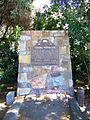
- The Canal Farm Inn is a California Historical Landmarks, number 548. It is located at 1460 E Pacheco Blvd, Los Banos.
The historical marker there says:
- NO. 548 CANAL FARM INN – This original San Joaquin Valley ranch headquarters of California pioneer and cattle baron Henry Miller (1827–1916) was established in 1873. His farsighted planning and development in the 1870s of a vast gravity irrigation system, and the founding of Los Banos in 1889, provided the basis for this area's present stability and wealth.
Notable People
- Mack Wheat (1893–1979) was a professional baseball catcher who played in Major League Baseball from 1915 to 1921.
Education
Students in Los Banos attend schools provided by the Los Banos Unified School District for their K–12 education. For those who want to continue their studies after high school, the Los Banos Campus of Merced College has been serving community college students since 2007.
Economy and Jobs
Los Banos has a variety of employers that provide jobs for its residents. Here are some of the top employers in the city, based on a 2018 report:
| # | Employer | # of Employees |
|---|---|---|
| 1 | Los Banos Unified School District | 1,082 |
| 2 | Walmart | 340 |
| 3 | Memorial Hospital Los Banos | 286 |
| 4 | Kagome | 206 |
| 5 | City of Los Banos | 178 |
| 6 | Target | 153 |
| 7 | APEX | 126 |
| 8 | The Home Depot | 125 |
| 9 | Save Mart | 90 |
| 10 | Central California Irrigation District | 75 |
Images for kids
-
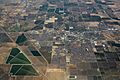
Aerial view of Los Banos
-
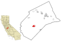
Location in Merced County and California
-
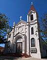
The Falasco Arts Center, housed in the historic St. Joseph's Church, Los Banos
-
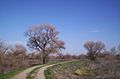
North levee, San Luis Refuge (March 2007)
-

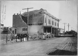
The Opera House in Los Banos following the 1906 San Francisco earthquake
-
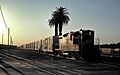
Switching in Los Banos, 1991
-
Canal Farm Inn, a California Historical Landmark
See also
 In Spanish: Los Baños (California) para niños
